Maizières, Pas-de-Calais
| Maizières | |
|---|---|
|
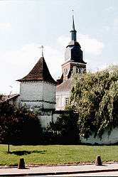
Dovecote and the church | |
 Maizières | |
|
Location within Hauts-de-France region  Maizières | |
| Coordinates: 50°19′28″N 2°26′55″E / 50.3244°N 2.4486°E / 50.3244; 2.4486Coordinates: 50°19′28″N 2°26′55″E / 50.3244°N 2.4486°E / 50.3244; 2.4486 | |
| Country | France |
| Region | Hauts-de-France |
| Department | Pas-de-Calais |
| Arrondissement | Arras |
| Canton | Aubigny-en-Artois |
| Intercommunality | Communauté de communes de l'Atrébatie |
| Government | |
| • Mayor (2008–2014) | Raymond Lavigne |
| Area1 | 6.86 km2 (2.65 sq mi) |
| Population (2006)2 | 167 |
| • Density | 24/km2 (63/sq mi) |
| Time zone | CET (UTC+1) |
| • Summer (DST) | CEST (UTC+2) |
| INSEE/Postal code | 62542 / 62127 |
| Elevation |
123–153 m (404–502 ft) (avg. 145 m or 476 ft) |
|
1 French Land Register data, which excludes lakes, ponds, glaciers > 1 km² (0.386 sq mi or 247 acres) and river estuaries. 2 Population without double counting: residents of multiple communes (e.g., students and military personnel) only counted once. | |
Maizières is a commune in the Pas-de-Calais department in the Hauts-de-France region of France.
Geography
Maizières is situated 16 miles (26 km) west of Arras, at the junction of the D8, D81 and the D82 roads.
Population
| Year | 1962 | 1968 | 1975 | 1982 | 1990 | 1999 | 2006 |
|---|---|---|---|---|---|---|---|
| Population | 216 | 223 | 175 | 173 | 177 | 177 | 167 |
| From the year 1962 on: No double counting—residents of multiple communes (e.g. students and military personnel) are counted only once. | |||||||
Places of interest
- The church of St.Leger, dating from the seventeenth century.
- An old dovecote.
See also
References
External links
| Wikimedia Commons has media related to Maizières (Pas-de-Calais). |
- Maizières on the Quid website (French)
| Authority control |
|---|
This article is issued from Wikipedia - version of the 11/6/2016. The text is available under the Creative Commons Attribution/Share Alike but additional terms may apply for the media files.