Habarcq
| Habarcq | ||
|---|---|---|
|
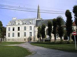
Church and chateau | ||
| ||
 Habarcq | ||
|
Location within Hauts-de-France region  Habarcq | ||
| Coordinates: 50°18′24″N 2°36′41″E / 50.3067°N 2.6114°ECoordinates: 50°18′24″N 2°36′41″E / 50.3067°N 2.6114°E | ||
| Country | France | |
| Region | Hauts-de-France | |
| Department | Pas-de-Calais | |
| Arrondissement | Arras | |
| Canton | Beaumetz-lès-Loges | |
| Intercommunality | Val de Gy | |
| Government | ||
| • Mayor (2008–2014) | Jean-Paul Accart | |
| Area1 | 7.03 km2 (2.71 sq mi) | |
| Population (1999)2 | 609 | |
| • Density | 87/km2 (220/sq mi) | |
| Time zone | CET (UTC+1) | |
| • Summer (DST) | CEST (UTC+2) | |
| INSEE/Postal code | 62399 / 62123 | |
| Elevation |
77–136 m (253–446 ft) (avg. 94 m or 308 ft) | |
|
1 French Land Register data, which excludes lakes, ponds, glaciers > 1 km² (0.386 sq mi or 247 acres) and river estuaries. 2 Population without double counting: residents of multiple communes (e.g., students and military personnel) only counted once. | ||

Habarcq is a commune in the Pas-de-Calais department in the Hauts-de-France region of France.
Geography
A small farming village situated 8 miles (13 km) west of Arras, at the junction of the D339 and the D7 roads.
Population
| Year | 1962 | 1968 | 1975 | 1982 | 1990 | 1999 |
|---|---|---|---|---|---|---|
| Population | 355 | 376 | 374 | 391 | 581 | 609 |
| From the year 1962 on: No double counting—residents of multiple communes (e.g. students and military personnel) are counted only once. | ||||||
Places of interest
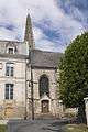
- The church of St.Martin, dating from the sixteenth century.
- The ruins of an old castle.
- The chateau, dating from the eighteenth century.
- The Commonwealth War Graves Commission cemetery.
See also
References
External links
| Wikimedia Commons has media related to Habarcq. |
 The church and chateau
 Detail on the church spire
This article is issued from Wikipedia - version of the 11/6/2016. The text is available under the Creative Commons Attribution/Share Alike but additional terms may apply for the media files.