Manin, Pas-de-Calais
| Manin | |
|---|---|
 | |
 Manin | |
|
Location within Hauts-de-France region  Manin | |
| Coordinates: 50°17′54″N 2°30′43″E / 50.2983°N 2.5119°E / 50.2983; 2.5119Coordinates: 50°17′54″N 2°30′43″E / 50.2983°N 2.5119°E / 50.2983; 2.5119 | |
| Country | France |
| Region | Hauts-de-France |
| Department | Pas-de-Calais |
| Arrondissement | Arras |
| Canton | Avesnes-le-Comte |
| Intercommunality | Communauté de communes de l'Atrébatie |
| Government | |
| • Mayor (2008–2014) | Gérard Mayeur |
| Area1 | 4.07 km2 (1.57 sq mi) |
| Population (2006)2 | 190 |
| • Density | 47/km2 (120/sq mi) |
| Time zone | CET (UTC+1) |
| • Summer (DST) | CEST (UTC+2) |
| INSEE/Postal code | 62544 / 62810 |
| Elevation |
113–152 m (371–499 ft) (avg. 125 m or 410 ft) |
|
1 French Land Register data, which excludes lakes, ponds, glaciers > 1 km² (0.386 sq mi or 247 acres) and river estuaries. 2 Population without double counting: residents of multiple communes (e.g., students and military personnel) only counted once. | |
Manin is a commune in the Pas-de-Calais department in the Hauts-de-France region of France.
Geography
Manin is situated 15 miles (24 km) west of Arras, at the junction of the D8 and the D78 roads.
Population
| Year | 1962 | 1968 | 1975 | 1982 | 1990 | 1999 | 2006 |
|---|---|---|---|---|---|---|---|
| Population | 143 | 149 | 146 | 151 | 158 | 178 | 190 |
| From the year 1962 on: No double counting—residents of multiple communes (e.g. students and military personnel) are counted only once. | |||||||
Places of interest
- The church of St.Maclou, dating from the eighteenth century.
- An eighteenth-century chateau.
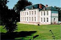
The château at Manin
See also
References
External links
| Wikimedia Commons has media related to Manin. |
- Manin on the Quid website (French)
| Authority control |
|---|
This article is issued from Wikipedia - version of the 11/6/2016. The text is available under the Creative Commons Attribution/Share Alike but additional terms may apply for the media files.