Couin
| Couin | ||
|---|---|---|
 | ||
| ||
 Couin | ||
|
Location within Hauts-de-France region  Couin | ||
| Coordinates: 50°07′50″N 2°33′09″E / 50.1306°N 2.5525°ECoordinates: 50°07′50″N 2°33′09″E / 50.1306°N 2.5525°E | ||
| Country | France | |
| Region | Hauts-de-France | |
| Department | Pas-de-Calais | |
| Arrondissement | Arras | |
| Canton | Pas-en-Artois | |
| Intercommunality | Deux Sources | |
| Government | ||
| • Mayor (2008–2014) | Francis Savoye | |
| Area1 | 5.82 km2 (2.25 sq mi) | |
| Population (1999)2 | 90 | |
| • Density | 15/km2 (40/sq mi) | |
| Time zone | CET (UTC+1) | |
| • Summer (DST) | CEST (UTC+2) | |
| INSEE/Postal code | 62242 / 62760 | |
| Elevation |
90–159 m (295–522 ft) (avg. 135 m or 443 ft) | |
|
1 French Land Register data, which excludes lakes, ponds, glaciers > 1 km² (0.386 sq mi or 247 acres) and river estuaries. 2 Population without double counting: residents of multiple communes (e.g., students and military personnel) only counted once. | ||

Couin is a commune in the Pas-de-Calais department in the Hauts-de-France region of France.
Geography
A small farming village located 16 miles (25 km) southwest of Arras at the junction of the D25 and D2 roads, by the banks of the Authie river.
Population
| Year | 1962 | 1968 | 1975 | 1982 | 1990 | 1999 |
|---|---|---|---|---|---|---|
| Population | 59 | 90 | 91 | 79 | 71 | 90 |
| From the year 1962 on: No double counting—residents of multiple communes (e.g. students and military personnel) are counted only once. | ||||||
Places of interest
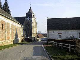
- The church of St.Pierre, dating from the seventeenth century.
- The eighteenth-century chateau.
- Three Commonwealth War Graves Commission cemeteries.

The chateau, built in 1748 by Philippe de Landas, Count of Louvignies
.
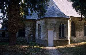
Part of the church
See also
References
External links
| Wikimedia Commons has media related to Couin. |
This article is issued from Wikipedia - version of the 8/20/2016. The text is available under the Creative Commons Attribution/Share Alike but additional terms may apply for the media files.