Vermelles
| Vermelles | |
|---|---|
 Vermelles | |
|
Location within Hauts-de-France region  Vermelles | |
| Coordinates: 50°29′20″N 2°44′48″E / 50.4889°N 2.7467°ECoordinates: 50°29′20″N 2°44′48″E / 50.4889°N 2.7467°E | |
| Country | France |
| Region | Hauts-de-France |
| Department | Pas-de-Calais |
| Arrondissement | Béthune |
| Canton | Cambrin |
| Intercommunality | Communauté d'agglomération de l'Artois |
| Government | |
| • Mayor (2008–2014) | Jean-Marc Déalet |
| Area1 | 10.39 km2 (4.01 sq mi) |
| Population (2006)2 | 4,496 |
| • Density | 430/km2 (1,100/sq mi) |
| Time zone | CET (UTC+1) |
| • Summer (DST) | CEST (UTC+2) |
| INSEE/Postal code | 62846 / 62980 |
| Elevation |
23–50 m (75–164 ft) (avg. 43 m or 141 ft) |
|
1 French Land Register data, which excludes lakes, ponds, glaciers > 1 km² (0.386 sq mi or 247 acres) and river estuaries. 2 Population without double counting: residents of multiple communes (e.g., students and military personnel) only counted once. | |
Vermelles is a commune in the Pas-de-Calais department in the Hauts-de-France region of France.
Geography
A ex-coalmining town, Vermelles is situated 6 miles (9.7 km) southeast of Béthune and 20 miles (32.2 km) southwest of Lille, at the junction of the D39, D75 and D943 roads and by the banks of the river Surgeon.
Population
| Year | 1962 | 1968 | 1975 | 1982 | 1990 | 1999 | 2006 |
|---|---|---|---|---|---|---|---|
| Population | 4208 | 4518 | 4299 | 4339 | 4584 | 4487 | 4496 |
| From the year 1962 on: No double counting—residents of multiple communes (e.g. students and military personnel) are counted only once. | |||||||
Places of interest
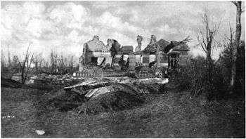
The Château de Vermelles, destroyed on 30 December 1914
- The church of St. Pierre, rebuilt, along with most of the village, after the First World War.
- The war memorials.
- The modern church of Notre-Dame.
- The Commonwealth War Graves Commission cemeteries.
Twin town
See also
References
External links
| Wikimedia Commons has media related to Vermelles. |
- The CWGC British cemetery
- The CWGC graves in the commune’s cemetery
- CWGC Quarry Cemetery at Vermelles
- Vermelles on the Quid website (French)
This article is issued from Wikipedia - version of the 11/8/2016. The text is available under the Creative Commons Attribution/Share Alike but additional terms may apply for the media files.