Cavron-Saint-Martin
| Cavron-Saint-Martin | ||
|---|---|---|
| ||
 Cavron-Saint-Martin | ||
|
Location within Hauts-de-France region  Cavron-Saint-Martin | ||
| Coordinates: 50°25′02″N 1°59′53″E / 50.4172°N 1.9981°ECoordinates: 50°25′02″N 1°59′53″E / 50.4172°N 1.9981°E | ||
| Country | France | |
| Region | Hauts-de-France | |
| Department | Pas-de-Calais | |
| Arrondissement | Montreuil | |
| Canton | Hesdin | |
| Intercommunality | Communauté de communes de l'Hesdinois | |
| Area1 | 11.86 km2 (4.58 sq mi) | |
| Population (2010)2 | 485 | |
| • Density | 41/km2 (110/sq mi) | |
| Time zone | CET (UTC+1) | |
| • Summer (DST) | CEST (UTC+2) | |
| INSEE/Postal code | 62220 / 62140 | |
| Elevation |
21–114 m (69–374 ft) (avg. 30 m or 98 ft) | |
|
1 French Land Register data, which excludes lakes, ponds, glaciers > 1 km² (0.386 sq mi or 247 acres) and river estuaries. 2 Population without double counting: residents of multiple communes (e.g., students and military personnel) only counted once. | ||

Cavron-Saint-Martin is a commune in the Pas-de-Calais département in the Hauts-de-France region of France.
Geography
Cavron St. Martin is in the valley of the Planquette, a tiny tributary of the Canche river.
Population
| Year | 1962 | 1968 | 1975 | 1982 | 1990 | 1999 | 2020 |
|---|---|---|---|---|---|---|---|
| Population | 363 | 406 | 409 | 429 | 382 | 402 | 485 |
| From the year 1962 on: No double counting—residents of multiple communes (e.g. students and military personnel) are counted only once. | |||||||
Places of interest
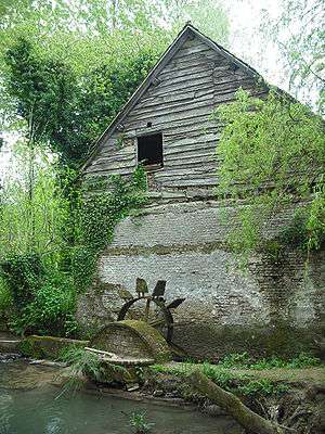
The watermill at Cavron-St.Martin
- The church of St.Walloy, dating from the fifteenth century.
- A disused watermill, behind the restaurant.
- A café-shop and 'La Planquette' restaurant.
- An estaminet, 'Chès Deux Agaches'. Here one can find reproductions (made by the owner) of traditional wooden pub games that can be played in the pub.
See also
References
External links
| Wikimedia Commons has media related to Cavron-Saint-Martin. |
This article is issued from Wikipedia - version of the 11/6/2016. The text is available under the Creative Commons Attribution/Share Alike but additional terms may apply for the media files.