Mingoval
| Mingoval | |
|---|---|
 | |
 Mingoval | |
|
Location within Hauts-de-France region  Mingoval | |
| Coordinates: 50°22′31″N 2°34′32″E / 50.3753°N 2.5756°E / 50.3753; 2.5756Coordinates: 50°22′31″N 2°34′32″E / 50.3753°N 2.5756°E / 50.3753; 2.5756 | |
| Country | France |
| Region | Hauts-de-France |
| Department | Pas-de-Calais |
| Arrondissement | Arras |
| Canton | Aubigny-en-Artois |
| Intercommunality | Communauté de communes de l'Atrébatie |
| Government | |
| • Mayor (2008–2014) | Jacques Deneux |
| Area1 | 3.79 km2 (1.46 sq mi) |
| Population (2006)2 | 206 |
| • Density | 54/km2 (140/sq mi) |
| Time zone | CET (UTC+1) |
| • Summer (DST) | CEST (UTC+2) |
| INSEE/Postal code | 62574 / 62690 |
| Elevation |
109–157 m (358–515 ft) (avg. 125 m or 410 ft) |
|
1 French Land Register data, which excludes lakes, ponds, glaciers > 1 km² (0.386 sq mi or 247 acres) and river estuaries. 2 Population without double counting: residents of multiple communes (e.g., students and military personnel) only counted once. | |
Mingoval is a commune in the Pas-de-Calais department in the Hauts-de-France region of France.
Geography
Mingoval is situated 12 miles (19 km) northwest of Arras, on the D73 road.
Population
| 1962 | 1968 | 1975 | 1982 | 1990 | 1999 | 2006 |
|---|---|---|---|---|---|---|
| 198 | 201 | 196 | 183 | 207 | 208 | 206 |
| Census count starting from 1962: Population without duplicates | ||||||
Places of interest
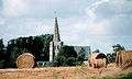
- The church of St.Liévin, dating from the eighteenth century.
- The seventeenth century cemetery entrance.
- An old farmhouse.
See also
References
External links
| Wikimedia Commons has media related to Mingoval. |
- Mingoval on the Quid website (French)
 Ancient entrance to the old farm
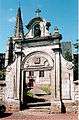 The churchyard entrance
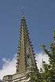 The church spire
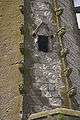 Architectural detail
 Typical regional houses
- The church
| Authority control |
|---|
This article is issued from Wikipedia - version of the 11/6/2016. The text is available under the Creative Commons Attribution/Share Alike but additional terms may apply for the media files.