Hénu
| Hénu | ||
|---|---|---|
|
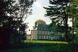
The chateau | ||
| ||
 Hénu | ||
|
Location within Hauts-de-France region  Hénu | ||
| Coordinates: 50°09′18″N 2°31′32″E / 50.155°N 2.5256°ECoordinates: 50°09′18″N 2°31′32″E / 50.155°N 2.5256°E | ||
| Country | France | |
| Region | Hauts-de-France | |
| Department | Pas-de-Calais | |
| Arrondissement | Arras | |
| Canton | Pas-en-Artois | |
| Intercommunality | Deux Sources | |
| Government | ||
| • Mayor (2008–2014) | Sebastien Desbureaux | |
| Area1 | 4.38 km2 (1.69 sq mi) | |
| Population (2006)2 | 161 | |
| • Density | 37/km2 (95/sq mi) | |
| Time zone | CET (UTC+1) | |
| • Summer (DST) | CEST (UTC+2) | |
| INSEE/Postal code | 62430 / 62760 | |
| Elevation |
104–162 m (341–531 ft) (avg. 152 m or 499 ft) | |
|
1 French Land Register data, which excludes lakes, ponds, glaciers > 1 km² (0.386 sq mi or 247 acres) and river estuaries. 2 Population without double counting: residents of multiple communes (e.g., students and military personnel) only counted once. | ||

Hénu is a commune in the Pas-de-Calais department in the Hauts-de-France region of France.
Geography
A small farming village situated 18 miles (29 km) southwest of Arras, on the D6 road.
Population
| Year | 1962 | 1968 | 1975 | 1982 | 1990 | 1999 | 2006 |
|---|---|---|---|---|---|---|---|
| Population | 154 | 178 | 147 | 127 | 143 | 152 | 161 |
| From the year 1962 on: No double counting—residents of multiple communes (e.g. students and military personnel) are counted only once. | |||||||
Places of interest
- The eighteenth-century chateau built by the de Coupigny family in 1745. It was seized during the French Revolution and used as a chicory factory.
- The church of St. Nicholas, dating from the eighteenth century.
- The Commonwealth War Graves Commission cemetery.
See also
References
External links
| Wikimedia Commons has media related to Hénu. |
This article is issued from Wikipedia - version of the 11/6/2016. The text is available under the Creative Commons Attribution/Share Alike but additional terms may apply for the media files.