HP postcode area

Postcode district boundaries: Bing / Google

KML is from Wikidata
Hemel Hempstead postcode area
HP
Postcode area HP
Postcode area name Hemel Hempstead
Post towns 11
Postcode districts 24
Postcode sectors 77
Postcodes (live) 13,743
Postcodes (total) 20,599
Statistics as at February 2012[1]

The HP postcode area, also known as the Hemel Hempstead postcode area,[2] is a group of twenty-four postcode districts in England which are subdivisions of eleven post towns. These postcode districts cover north-west Hertfordshire and much of Buckinghamshire.

The main sorting office is in Hemel Hempstead (Maylands Avenue HP2) and the area served includes most of the Dacorum district of Hertfordshire and most of the Chiltern, Wycombe and Aylesbury Vale districts of Buckinghamshire, as well as a small part of the South Bucks district.
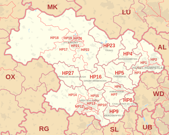
Coverage

The approximate coverage of the postcode districts:

Postcode district Post town Coverage Local authority area
HP1 HEMEL HEMPSTEAD Bourne End, Boxmoor, Chaulden, Fields End, Gadebridge, Great Gaddesden, Nettleden, Piccotts End, Water End, Warner's End Dacorum
HP2 HEMEL HEMPSTEAD Gaddesden Row, Piccotts End, Grovehill, Adeyfield, Hemel Hempstead Industrial Estate Dacorum
HP3 HEMEL HEMPSTEAD Apsley, Bovingdon, Felden, Flaunden, Hemel Hempstead, Leverstock Green Dacorum
HP4 BERKHAMSTED Berkhamsted, Dagnall, Dudswell, Little Gaddesden, Northchurch, Potten End, Ringshall Dacorum, Aylesbury Vale
HP5 CHESHAM Chesham, Ashley Green, Bellingdon, Botley, Chartridge, Hawridge, Latimer, Lye Green, Newtown, Waterside, Whelpley Hill Chiltern
HP6 AMERSHAM Amersham (north), Chesham Bois, Hyde Heath, Little Chalfont Chiltern
HP7 AMERSHAM Amersham (south), Coleshill, Little Chalfont, Little Missenden, Penn Street, Winchmore Hill Chiltern
HP8 CHALFONT ST. GILES Chalfont St Giles Chiltern
HP9 BEACONSFIELD Beaconsfield, Forty Green, Holtspur, Jordans, Knotty Green, Seer Green South Bucks, Chiltern
HP10 HIGH WYCOMBE High Wycombe, Flackwell Heath, Handy Cross, Hedsor, Loudwater, Penn, Tylers Green, Wooburn, Wooburn Green, Wooburn Moor Wycombe, Chiltern
HP11 HIGH WYCOMBE Wycombe Marsh Wycombe
HP12 HIGH WYCOMBE High Wycombe, Booker, Sands Wycombe
HP13 HIGH WYCOMBE High Wycombe, Downley, Totteridge Wycombe
HP14 HIGH WYCOMBE Beacon's Bottom, Bledlow Ridge, Bolter End, Bradenham, Cadmore End, Hughenden Valley, Ibstone, Lane End, Naphill, Northend, Stokenchurch, The City, Upper North Dean, West Wycombe Wycombe
HP15 HIGH WYCOMBE Cryers Hill, Great Kingshill, Hazlemere, Holmer Green, Hughenden Valley Wycombe, Chiltern
HP16 GREAT MISSENDEN Great Missenden, Ballinger, The Lee, Little Hampden, Little Kingshill, Prestwood, South Heath Chiltern, Wycombe
HP17 AYLESBURY Aston Sandford, Bishopstone, Butler's Cross, Dinton, Dorton, Ellesborough, Ford, The Kimbles, Kingsey, Haddenham, Meadle, Nash Lee, Stone, Upton, Westlington Aylesbury Vale
HP18 AYLESBURY Ashendon, Boarstall, Brill, Chearsley, Chilton, Cuddington, Dorton, Easington, Edgcott, Grendon Underwood, Ickford, Kingswood, Long Crendon, Lower Winchendon, Ludgershall, Oakley, Shabbington, Upper Winchendon, Waddesdon, Westcott, Worminghall, Wotton Underwood Aylesbury Vale
HP19 AYLESBURY Aylesbury, Berryfields, Buckingham Park, Fairford Leys, Prebendal Farm, Quarrendon, Watermead Aylesbury Vale
HP20 AYLESBURY Aylesbury, Aylesbury Town Centre, Broughton, Elmhurst Aylesbury Vale
HP21 AYLESBURY Aylesbury, Bedgrove, Elm Farm, Queens Park, Southcourt, Walton, Walton Court Aylesbury Vale
HP22 AYLESBURY Aston Abbotts, Aston Clinton, Bierton, Buckland, Drayton Beauchamp, Dunsmore, Halton, Hardwick, Hulcott, North Lee, Nup End, Oving, Pitchcott, Quainton, Rowsham, Stoke Mandeville, Weedon, Wendover, Weston Turville, Whitchurch, Wingrave Aylesbury Vale
HP22 PRINCES RISBOROUGH non-geographic[3][4]
HP23 TRING Aldbury, Buckland Common, Cholesbury, Hastoe, Long Marston, Marsworth, New Mill, Puttenham, St Leonards, Tring, Wigginton, Wilstone Dacorum, Chiltern
HP27 PRINCES RISBOROUGH Askett, Bledlow, Ilmer, Lacey Green, Longwick, Loosley Row, Monks Risborough, Owlswick, Pitch Green, Princes Risborough, Saunderton, Speen Wycombe

Map

KML is from Wikidata
HP postcode area map, showing postcode districts, post towns and neighbouring postcode areas. AL postcode area HA postcode area LU postcode area MK postcode area OX postcode area RG postcode area RG postcode area SL postcode area UB postcode area UB postcode area WD postcode area
HP postcode area map, showing postcode districts in red and post towns in grey text, with links to nearby AL, LU, MK, OX, RG, SL, UB and WD postcode areas.

See also

References

  1. "ONS Postcode Directory Version Notes" (ZIP). National Statistics Postcode Products. Office for National Statistics. February 2012. Table 2. Retrieved 21 April 2012. Coordinates from mean of unit postcode points, "Code-Point Open". OS OpenData. Ordnance Survey. February 2012. Retrieved 21 April 2012.
  2. Royal Mail, Address Management Guide, (2004)
  3. "Non Geographic Codes" (PDF). Royal Mail Address Management Unit. July 2012. Retrieved 20 December 2012.
  4. "New sectors and localities to 14 December 2012" (PDF). Royal Mail Address Management Unit. 20 December 2012. Retrieved 20 December 2012.

External links

This article is issued from Wikipedia - version of the 12/1/2016. The text is available under the Creative Commons Attribution/Share Alike but additional terms may apply for the media files.