NR postcode area

Wikimedia Commons has media related to Post boxes in NR postcode area.

Postcode district boundaries: Bing / Google

KML is from Wikidata
Norwich postcode area
NR
Postcode area NR
Postcode area name Norwich
Post towns 16
Postcode districts 36
Postcode sectors 114
Postcodes (live) 22,735
Postcodes (total) 26,980
Statistics as at February 2012[1]

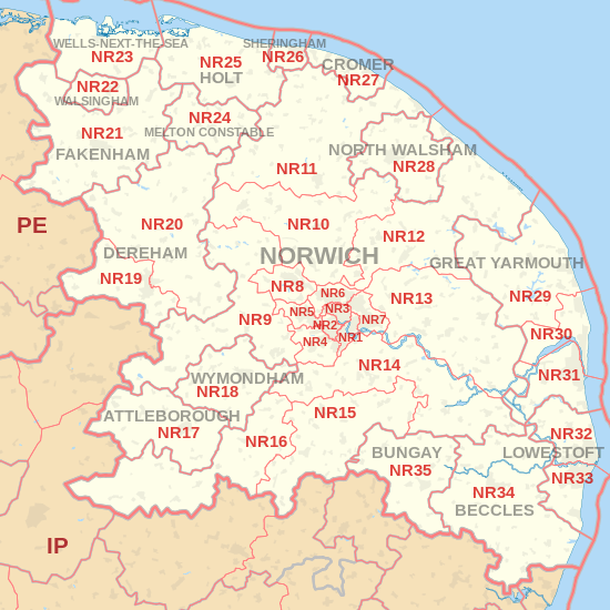
The NR postcode area, also known as the Norwich postcode area,[2] is a group of postcode districts covering much of Norfolk and parts of the adjacent county of Suffolk in the East Anglian area of England.

Coverage

The approximate coverage of the postcode districts:

Postcode district Post town Coverage Local authority area
NR1 NORWICH Thorpe Hamlet, (parts of) City Centre, areas close to Thorpe Road Mail Centre Norwich
NR2 NORWICH Eaton, western and south-western parts of Norwich and parts of the city centre Norwich
NR3 NORWICH N part of Norwich, within the ring-road: Upper Hellesdon, New Catton Norwich, Broadland
NR4 NORWICH Villages W and SW of Norwich: Cringleford, Colney, Keswick South Norfolk
NR5 NORWICH W and NW suburbs of Norwich: Bowthorpe, Costessey Norwich, South Norfolk
NR6 NORWICH N and NW suburbs of Norwich: Old Catton, Hellesdon Norwich, Broadland
NR7 NORWICH E and SE suburbs of Norwich: Sprowston, Thorpe St. Andrew, Heartsease Norwich, Broadland
NR8 NORWICH Suburbs and villages NW of Norwich: Drayton, Taverham, Ringland Broadland
NR9 NORWICH Villages W and NW of Norwich: Barford, Bawburgh, Hethersett, Honingham, Lenwade, Little Melton, Lyng, Marlingford and Colton, Weston Longville Broadland
NR10 NORWICH Villages and towns N and NW of Norwich: Pettywell, Reepham, Hevingham, Stratton Strawless, Horsham St Faith Broadland, South Norfolk
NR11 NORWICH Alby with Thwaite, Aldborough, Aylmerton, Aylsham, Banningham, Blickling, East Beckham, Little Barningham, Hanworth, North Barningham, Roughton, Felbrigg, Gimingham, Ingworth, Matlask, Mundesley, Southrepps, Wickmere North Norfolk
NR12 NORWICH Bacton, Brumstead, Coltishall, East Ruston, Hickling, Ingham, Lessingham, Sloley, Stalham, Tunstead, Wroxham North Norfolk
NR13 NORWICH Towns and villages E of Norwich: Acle, Brundall, Reedham, Rackheath, Salhouse Broadland
NR14 NORWICH Suburbs and villages SE of Norwich: Loddon, Poringland, Trowse, Haddiscoe South Norfolk
NR15 NORWICH Long Stratton South Norfolk
NR16 NORWICH Larling Breckland
NR17 ATTLEBOROUGH Little & Great Ellingham Breckland
NR18 NORWICH non-geographic[3]
NR18 WYMONDHAM Wymondham South Norfolk
NR19 NORWICH non-geographic[4][5]
NR19 DEREHAM Dereham Breckland
NR20 DEREHAM Villages N and E of Dereham: Bawdeswell, Bylaugh, Elsing, Foxley, Foulsham, Gressenhall, Guestwick, Hockering, Mattishall, Whissonsett, Nethergate, North Elmham, Swanton Morley, Themelthorpe Breckland
NR21 FAKENHAM Barsham, Binham, Fakenham, Fulmodeston, South Raynham, East Raynham, West Raynham, Hempton, Helhoughton, Hindringham, Gunthorpe, Tatterford, Toftrees North Norfolk
NR22 WALSINGHAM Walsingham, Houghton St Giles, North Barsham North Norfolk
NR23 WELLS-NEXT-THE-SEA Quarles, Warham, Wells-next-the-Sea, Wighton North Norfolk
NR24 MELTON CONSTABLE Stody, Briston, Briningham, Brinton, Edgefield, Sharrington, Melton Constable, Plumstead, Swanton Novers North Norfolk
NR25 HOLT Kelling, Baconsthorpe, Blakeney, Bodham, Cley next the Sea, Edgfield, Hempstead, High Kelling, HunworthLangham, Letheringsett, Glandford, Weybourne, West Beckham, Salthouse North Norfolk
NR26 NORWICH non-geographic[3]
NR26 SHERINGHAM Beeston Regis, West Runton, Upper Sheringham North Norfolk
NR27 CROMER Cromer, East Runton, Frogshall, Trimingham, Northrepps, Overstrand North Norfolk
NR28 NORTH WALSHAM Antingham, Crostwight, Honing, Knapton, Paston, Ridlington North Norfolk
NR28 NORWICH non-geographic[3]
NR29 GREAT YARMOUTH Hemsby, Rollesby
NR30 GREAT YARMOUTH Caister-on-Sea, West Caister Great Yarmouth
NR31 GREAT YARMOUTH Gorleston, Bradwell Great Yarmouth
NR32 LOWESTOFT North Lowestoft Waveney
NR33 LOWESTOFT South Lowestoft Waveney
NR34 BECCLES Beccles, Worlingham Waveney
NR35 BUNGAY Bungay, Topcroft, Flixton Waveney
NR99 non-geographic non-geographic[4]
non-geographic[4]

Map

KML is from Wikidata
NR postcode area map, showing postcode districts, post towns and neighbouring postcode areas. IP postcode area PE postcode area
NR postcode area map, showing postcode districts in red and post towns in grey text, with links to nearby IP and PE postcode areas.

See also

References

  1. "ONS Postcode Directory Version Notes" (ZIP). National Statistics Postcode Products. Office for National Statistics. February 2012. Table 2. Retrieved 21 April 2012. Coordinates from mean of unit postcode points, "Code-Point Open". OS OpenData. Ordnance Survey. February 2012. Retrieved 21 April 2012.
  2. Royal Mail, Address Management Guide, (2004)
  3. 1 2 3 "New sectors and localities to 16 November 2012" (PDF). Royal Mail Address Management Unit. 19 November 2012. Retrieved 29 November 2012.
  4. 1 2 3 "Non Geographic Codes" (PDF). Royal Mail Address Management Unit. July 2012. Archived from the original (PDF) on September 16, 2012. Retrieved 20 December 2012.
  5. "New sectors and localities to 14 December 2012" (PDF). Royal Mail Address Management Unit. 20 December 2012. Archived from the original (PDF) on February 2, 2015. Retrieved 20 December 2012.
This article is issued from Wikipedia - version of the 12/2/2016. The text is available under the Creative Commons Attribution/Share Alike but additional terms may apply for the media files.