CH postcode area

Postcode district boundaries: Bing / Google

KML is from Wikidata
Chester postcode area
CH
Postcode area CH
Postcode area name Chester
Post towns 13
Postcode districts 37
Postcode sectors 213
Postcodes (live) 18,595
Postcodes (total) 23,317
Statistics as at February 2012[1]

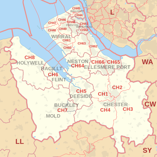
The CH postcode area, also known as the Chester postcode area,[2] is a group of postcode districts near the England/Wales border. Having previously roughly covered the former Chester district and present-day Flintshire county, postcodes for the Wirral Peninsula (CH41-49, 60-66) were transferred to it in 1999 from the L postcode area.[3] It includes Birkenhead, Chester, Ellesmere Port, Neston, Prenton and Wallasey in England and Bagillt, Buckley, Connah's Quay, Flint, Holywell and Mold in Wales.

Coverage

The approximate coverage of the postcode districts:

Postcode district Post town Coverage Local authority area
CH1 CHESTER Blacon, Chester, Higher Ferry, Capenhurst, Backford Cheshire West and Chester, Flintshire County Council
CH2 CHESTER Backford, Chester, Elton, Hoole, Ince, Mickle Trafford, Moston, Upton by Chester Cheshire West and Chester
CH3 CHESTER Boughton, Chester, Huntington, Mouldsworth, Tarvin, Tattenhall, Farndon, Waverton, Saighton, Upton by Chester Cheshire West and Chester
CH4 CHESTER Chester, Curzon Park, Handbridge, Lache, Pulford, Penyffordd, Broughton, Saltney Cheshire West and Chester, Flintshire County Council
CH5 DEESIDE Connah's Quay, Shotton, Queensferry, Sealand, Garden City, Sandycroft, Hawarden, Ewloe, Mancot. Flintshire
CH6 BAGILLT, FLINT Flint, Oakenholt, Flint Mountain, The Nant, Bagillt Flintshire
CH7 BUCKLEY, MOLD Buckley, Leeswood, Treuddyn, Llanarmon-yn-Ial, Caerwys, Mold, Northop Hall, Drury Flintshire, Denbighshire council
CH8 HOLYWELL Holywell, Milwr, Holway, Carmel, Lloc, Bryn Celyn, Greenfield, Halkyn, Lixwm, Talacre Flintshire
CH25 BIRKENHEAD PO Boxes Metropolitan Borough of Wirral
CH26 PRENTON PO Boxes Wirral
CH27 WALLASEY Wallasey[nb 1] Wirral
CH28 WIRRAL PO Boxes in Moreton Wirral
CH29 WIRRAL PO Boxes in Hoylake Wirral
CH30 WIRRAL PO Boxes in Upton Wirral
CH31 WIRRAL PO Boxes in Heswall Wirral
CH32 WIRRAL PO Boxes in New Ferry Wirral
CH33 NESTON PO Boxes Cheshire West and Chester
CH34 ELLESMERE PORT PO Boxes Cheshire West and Chester
CH41 BIRKENHEAD Birkenhead, Claughton, Seacombe, Tranmere, Woodside Wirral
CH42 BIRKENHEAD Birkenhead, Oxton, Prenton, Rock Ferry, Wirral
CH43 PRENTON Beechwood, Bidston, Noctorum, Oxton, Prenton Wirral
CH44 WALLASEY Egremont, Liscard, Poulton, Seacombe, Wallasey, Wirral
CH45 WALLASEY New Brighton, Wallasey, Wallasey Village Wirral
CH46 WIRRAL Leasowe, Moreton Wirral
CH47 WIRRAL Hoylake, Meols, Saughall Massie, West Kirby Wirral
CH48 WIRRAL Caldy, Frankby, Grange, Greasby, Hoylake, Meols, Newton, West Kirby Wirral
CH49 WIRRAL Greasby, Landican, Saughall Massie, Upton, Woodchurch Wirral
CH60 WIRRAL Gayton, Heswall Wirral
CH61 WIRRAL Barnston, Heswall, Irby, Pensby, Thingwall, Thurstaston Wirral
CH62 WIRRAL Bromborough, Eastham, New Ferry, Port Sunlight, Spital, Wirral
CH63 WIRRAL Bebington, Brimstage, Bromborough, Clatterbridge, Higher Bebington, Raby, Raby Mere, Spital, Storeton, Thornton Hough, Wirral
CH64 NESTON Little Neston, Ness, Neston, Parkgate, Puddington, Willaston, Cheshire West and Chester
CH65 ELLESMERE PORT Ellesmere Port, Great Sutton, Whitby, Wolverham Cheshire West and Chester
CH66 ELLESMERE PORT Childer Thornton, Ellesmere Port, Great Sutton, Hooton, Ledsham, Little Sutton, Overpool, Whitby Cheshire West and Chester
CH70 CHESTER Department for Work and Pensions[4]
CH88 CHESTER North West Securities Bank[4]
CH99 CHESTER Benefits Agency,[4] St. Michaels Financial Services & Chargecard[4]

Map

KML is from Wikidata
CH postcode area map, showing postcode districts, post towns and neighbouring postcode areas. CW postcode area L postcode area LL postcode area SY postcode area WA postcode area
CH postcode area map, showing postcode districts in red and post towns in grey text, with links to nearby CW, L, LL, SY and WA postcode areas.

See also

Notes

  1. This may only be used for PO Boxes now. There are live geographical postcodes, but (for example) Wallasey Town Hall is usually given the postcode CH44 8ED rather than CH27 9ZZ.

References

  1. "ONS Postcode Directory Version Notes" (ZIP). National Statistics Postcode Products. Office for National Statistics. February 2012. Table 2. Retrieved 21 April 2012. Coordinates from mean of unit postcode points, "Code-Point Open". OS OpenData. Ordnance Survey. February 2012. Retrieved 21 April 2012.
  2. Royal Mail, Address Management Guide, (2004)
  3. "Why we are changing postcodes – Royal Mail". Wirral Globe website. Newsquest Media Group. 18 March 1999. Retrieved 29 May 2009.
  4. 1 2 3 4 "RM non-geographical postcode list" (PDF).

External links

This article is issued from Wikipedia - version of the 10/20/2016. The text is available under the Creative Commons Attribution/Share Alike but additional terms may apply for the media files.