W postcode area
Postcode district boundaries: Bing / Google
| London W postcode area | |
|---|---|
 W | |
| Postcode area | W |
| Postcode area name | London W |
| Post towns | 1 |
| Postcode districts | 35 |
| Postcode sectors | 217 |
| Postcodes (live) | 20,005 |
| Postcodes (total) | 38,824 |
| Statistics as at February 2012[1] | |
The W (Western and Paddington) postcode area, also known as the London W postcode area[2] is a group of postcode districts covering part of central and part of west London, England. The area originates from the Western (W1) and Paddington (W2-14) districts[3] of the London postal district.
Postal administration
The Western district[3] consists of the single original W1 postal district.[4] The area it covers is of very high density development and it has been subdivided into a number of smaller postcode districts. Where districts are used for purposes other than the sorting of mail, such as use as a geographic reference and on street signs, the W1 subdivisions continue to be classed as one 'district'. In June 2000 there was a recoding of the area with the W1M, W1N, W1P, W1R, W1V, W1X and W1Y districts replaced.[5]
The mail centre for W1 is London Central and for W2-14 is Greenford.
Deliveries for W1 (and for WC1 and WC2) came from the Western District Office office on Rathbone Place, until it was decommissioned. This office was a stop on the former London Post Office Railway, which has been mothballed since 2003. The Western District Office was initially located on Wimpole Street, which was also a stop on the London Post Office Railway.
The Paddington district[3] consists of thirteen postcode districts (W2–14).[4] Apart from W2, the districts are arranged alphabetically, running from W3 (Acton) to W14 (West Kensington) and radiate westwards. The Paddington Head District Sorting Office was the western terminus of the London Post Office railway, which ran 6.5 miles (10.5 km) to the Eastern District Office at Whitechapel.
List of postcode districts
The approximate coverage of the postcode districts, with the historic postal district names shown in italics:[4][6]
| Postcode district | Post town | Coverage | Local authority area |
|---|---|---|---|
| W1A | LONDON | PO boxes & Admail codes in W1[7] | non-geographic |
| W1B | LONDON | Portland Place, Regent Street | Westminster |
| W1C | LONDON | Oxford Street (west) | Westminster |
| W1D | LONDON | Soho (south east); Chinatown, Soho Square | Westminster |
| W1F | LONDON | Soho (north west) | Westminster |
| W1G | LONDON | Harley Street | Westminster |
| W1H | LONDON | Marylebone | Westminster |
| W1J | LONDON | Mayfair (south), Piccadilly, Royal Academy | Westminster |
| W1K | LONDON | Mayfair (north), Grosvenor Square | Westminster |
| W1S | LONDON | Mayfair (east), Hanover Square, Savile Row | Westminster |
| W1T | LONDON | Fitzrovia, Tottenham Court Road | Camden |
| W1U | LONDON | Marylebone | Westminster |
| W1W | LONDON | Great Portland Street, Fitzrovia | Westminster |
| W2 | LONDON | Paddington head district: Paddington, Bayswater, Hyde Park, Westbourne Green, Little Venice (part), Notting Hill (part) | Westminster, Kensington and Chelsea |
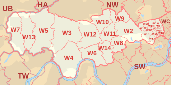
| W3 | LONDON | Acton district: Acton, West Acton, North Acton (part), South Acton, East Acton (west), Park Royal (south), Hanger Hill Garden Estate, Gunnersbury Park | Ealing, Hounslow, Hammersmith and Fulham |
| W4 | LONDON | Chiswick district: Chiswick, Gunnersbury, Turnham Green, Acton Green, South Acton (part), Bedford Park | Hounslow, Ealing, Hammersmith and Fulham |
| W5 | LONDON | Ealing district: Ealing, South Ealing, Ealing Common, North Ealing, Northfields, (south and east), Pitshanger, Hanger Lane | Ealing, Hounslow |
| W6 | LONDON | Hammersmith district: Hammersmith, Ravenscourt Park, Stamford Brook (part) | Hammersmith and Fulham, Hounslow |
| W7 | LONDON | Hanwell district: Hanwell, Boston Manor (part) | Ealing, Hounslow |
| W8 | LONDON | Kensington district: Kensington, Holland Park (part) | Kensington and Chelsea |
| W9 | LONDON | Maida Hill district: Maida Hill, Maida Vale, Little Venice (part) | Westminster, Brent, Camden |
| W10 | LONDON | North Kensington district: North Kensington, Kensal Town, Ladbroke Grove (north), Queen's Park (part) | Kensington and Chelsea, Westminster, Hammersmith and Fulham, Brent |
| W11 | LONDON | Notting Hill district: Notting Hill, Ladbroke Grove (south), Holland Park (part) | Kensington and Chelsea, Westminster, Hammersmith and Fulham |
| W12 | LONDON | Shepherds Bush district: Shepherds Bush, White City, Wormwood Scrubs, East Acton (east) | Hammersmith and Fulham |
| W13 | LONDON | West Ealing district: West Ealing, Northfields (north and west) | Ealing |
| W14 | LONDON | West Kensington district: West Kensington, Kensington Olympia, Holland Park | Hammersmith and Fulham, Kensington and Chelsea |
Boundaries
Postcode districts W1 and W2 are central to London, while W3 to W14 radiate outwards to the west. The boundaries of the area and its numbered districts have changed over time and are the result of the working requirements of the Royal Mail. They are not tied to those of the local authority areas served; consequently a locality name might describe varying areas. W1 is almost entirely in the City of Westminster, with a small part in the London Borough of Camden. W2 to W14 cover the northwestern part of the City of Westminster, the northern parts of the Royal Borough of Kensington and Chelsea and the London Borough of Hammersmith and Fulham, and the eastern parts of the London Boroughs of Ealing and Hounslow, plus very small parts of the London Boroughs of Brent and Camden.
Map
See also
References
- ↑ "ONS Postcode Directory Version Notes" (ZIP). National Statistics Postcode Products. Office for National Statistics. February 2012. Table 2. Retrieved 21 April 2012. Coordinates from mean of unit postcode points, "Code-Point Open". OS OpenData. Ordnance Survey. February 2012. Retrieved 21 April 2012.
- ↑ Royal Mail (2004). Address Management Guide (4 ed.). Royal Mail Group.
- 1 2 3 Monopolies and Mergers Commission (1980). The Inner London Letter Post. HMSO.
- 1 2 3 "Names of Streets and Places in the London Postal area". HMSO. 1930.
- ↑ Royal Mail (18 April 2007). "Royal Mail major recode historical information – 2000 to March 2007" (PDF). Royal Mail Group. Retrieved 1 April 2010.
- ↑ Map of London district names and numbers, from the 1963 edition of Bartholomew's Reference Atlas of Greater London
- ↑ "Non Geographic Codes" (PDF). Royal Mail Address Management Unit. July 2012. Retrieved 25 September 2012.
External links
- "W1". The Postcodes Project. Museum of London. Archived from the original on 3 November 2012.
- "W2". The Postcodes Project. Museum of London. Archived from the original on 23 September 2012.
- "W3". The Postcodes Project. Museum of London. Archived from the original on 23 September 2012.
- "W4". The Postcodes Project. Museum of London. Archived from the original on 23 September 2012.
- "W5". The Postcodes Project. Museum of London. Archived from the original on 23 September 2012.
- "W6". The Postcodes Project. Museum of London. Archived from the original on 23 September 2012.
- "W7". The Postcodes Project. Museum of London. Archived from the original on 23 September 2012.
- "W8". The Postcodes Project. Museum of London. Archived from the original on 23 September 2012.
- "W9". The Postcodes Project. Museum of London. Archived from the original on 16 December 2012.
- "W10". The Postcodes Project. Museum of London. Archived from the original on 24 September 2012.
- "W11". The Postcodes Project. Museum of London. Archived from the original on 24 September 2012.
- "W12". The Postcodes Project. Museum of London. Archived from the original on 24 September 2012.
- "W13". The Postcodes Project. Museum of London. Archived from the original on 17 November 2012.
- "W14". The Postcodes Project. Museum of London. Archived from the original on 24 September 2012.