HU postcode area
Postcode district boundaries: Bing / Google
| Hull postcode area | |
|---|---|
 HU | |
| Postcode area | HU |
| Postcode area name | Hull |
| Post towns | 8 |
| Postcode districts | 21 |
| Postcode sectors | 69 |
| Postcodes (live) | 10,770 |
| Postcodes (total) | 14,608 |
| Statistics as at February 2012[1] | |
The HU postcode area, also known as the Hull postcode area,[2] is a group of postcode districts around Beverley, Brough, Cottingham, Hessle, Hornsea, Hull, North Ferriby and Withernsea in England.
Coverage
The approximate coverage of the postcode districts:
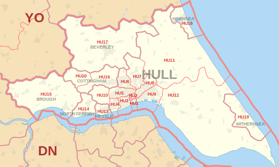
| Postcode district | Post town | Coverage | Local authority area |
|---|---|---|---|
| HU1 | HULL | Hull | Kingston upon Hull |
| HU2 | HULL | Hull | Kingston upon Hull |
| HU3 | HULL | Hull, Spring Bank | Kingston upon Hull |
| HU4 | HULL | Hull, Anlaby Common, Anlaby Park, Gipsyville | Kingston upon Hull |
| HU5 | HULL | Hull, The Avenues | Kingston upon Hull |
| HU6 | HULL | Hull, Dunswell, Orchard Park, Greenwood | Kingston upon Hull |
| HU7 | HULL | Hull, Bransholme, Kingswood, Sutton-on-Hull, Wawne | Kingston upon Hull |
| HU8 | HULL | Hull, Garden Village, Ings, Longhill, Sutton-on-Hull | Kingston upon Hull |
| HU9 | HULL | Hull, Drypool, Victoria Dock, Marfleet, Preston Road, Greatfield, Bilton Grange | Kingston upon Hull |
| HU10 | HULL | Anlaby, Kirk Ella, West Ella, Willerby | East Riding of Yorkshire |
| HU11 | HULL | Bilton | East Riding of Yorkshire |
| HU12 | HULL | Hedon, Patrington, Preston | East Riding of Yorkshire |
| HU13 | HESSLE | Hessle | East Riding of Yorkshire |
| HU14 | NORTH FERRIBY | North Ferriby, Melton, Swanland | East Riding of Yorkshire |
| HU15 | BROUGH | Elloughton-cum-Brough, South Cave, Welton | East Riding of Yorkshire |
| HU16 | COTTINGHAM | Cottingham, Eppleworth, Raywell, Skidby | East Riding of Yorkshire |
| HU17 | BEVERLEY | Beverley, Bishop Burton, Walkington | East Riding of Yorkshire |
| HU18 | HORNSEA | Hornsea, Mappleton, Rolston | East Riding of Yorkshire |
| HU19 | WITHERNSEA | Withernsea, Hollym, Holmpton, Out Newton, Rimswell, Waxholme | East Riding of Yorkshire |
| HU20 | COTTINGHAM | High Hunsley, Little Weighton, Low Hunsley, Riplingham | East Riding of Yorkshire |
Map
See also
References
- ↑ "ONS Postcode Directory Version Notes" (ZIP). National Statistics Postcode Products. Office for National Statistics. February 2012. Table 2. Retrieved 21 April 2012. Coordinates from mean of unit postcode points, "Code-Point Open". OS OpenData. Ordnance Survey. February 2012. Retrieved 21 April 2012.
- ↑ Royal Mail, Address Management Guide, (2004)
External links
This article is issued from Wikipedia - version of the 4/12/2016. The text is available under the Creative Commons Attribution/Share Alike but additional terms may apply for the media files.