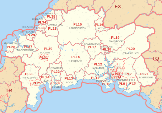
| Postcode district |
Post town |
Coverage |
Local authority area |
| PL1 |
PLYMOUTH |
Plymouth, Devonport, The Hoe, Millbridge, Stoke, Stonehouse |
Plymouth City Council |
| PL2 |
PLYMOUTH |
Beacon Park, Ford, Keyham, North Prospect, Pennycross, Home Park |
Plymouth City Council |
| PL3 |
PLYMOUTH |
Efford, Hartley, Laira, Mannamead, Milehouse, Peverell, Higher Compton |
Plymouth City Council |
| PL4 |
PLYMOUTH |
Barbican, Lipson, Mount Gould, Mutley, Prince Rock, St. Judes |
Plymouth City Council |
| PL5 |
PLYMOUTH |
Crownhill, Ernesettle, Honicknowle, Whitleigh, St. Budeaux, Tamerton Foliot |
Plymouth City Council |
| PL6 |
PLYMOUTH |
Derriford, Eggbuckland, Estover, Leigham, Roborough, Southway |
Plymouth City Council |
| PL7 |
PLYMOUTH |
Plympton, Sparkwell |
Plymouth City Council |
| PL8 |
PLYMOUTH |
Brixton, Newton Ferrers, Noss Mayo, Yealmpton |
South Hams |
| PL9 |
PLYMOUTH |
Plymstock, Heybrook Bay, Mount Batten, Wembury |
Plymouth City Council |
| PL10 |
TORPOINT |
Cawsand, Cremyll, Fort Picklecombe, Freathy, Kingsand, Millbrook |
Cornwall Council |
| PL11 |
TORPOINT |
Torpoint, Antony, Crafthole, Downderry, Seaton, Sheviock, St John |
Cornwall Council |
| PL12 |
SALTASH |
Saltash, Hatt, Landrake, St Germans, Tideford, Trerulefoot |
Cornwall Council |
| PL13 |
LOOE |
Looe, Lansallos, Polperro |
Cornwall Council |
| PL14 |
LISKEARD |
Liskeard, Dobwalls, Doublebois, Minions, St Cleer, St Ive, St Neot |
Cornwall Council |
| PL15 |
LAUNCESTON |
Launceston, Bolventor, Lezant, South Petherwin, Treneglos |
Cornwall Council |
| PL16 |
LIFTON |
Lifton, Broadwoodwidger, Marystow |
West Devon |
| PL17 |
CALLINGTON |
Callington, Ashton, Bray Shop, Kelly Bray, South Hill |
Cornwall Council |
| PL18 |
CALSTOCK, GUNNISLAKE |
Calstock, Gunnislake, Albaston |
Cornwall Council |
| PL19 |
TAVISTOCK |
Tavistock, Bradstone, Mary Tavy, Morwellham, Peter Tavy, Whitchurch |
West Devon |
| PL20 |
YELVERTON |
Yelverton, Bellever, Crapstone, Horrabridge, Postbridge, Princetown, Two Bridges |
West Devon |
| PL21 |
IVYBRIDGE |
Ivybridge, Brownston, Cornwood, Ermington, Modbury, Ugborough |
South Hams |
| PL22 |
LOSTWITHIEL |
Lostwithiel, Boconnoc, Lanlivery, Lerryn, St Veep |
Cornwall Council |
| PL23 |
FOWEY |
Fowey, Bodinnick, Golant, Polruan |
Cornwall Council |
| PL24 |
PAR |
Par, Polkerris, St Blazey, Tywardreath |
Cornwall Council |
| PL25 |
ST. AUSTELL |
St Austell, Carlyon Bay, Charlestown, Trewoon |
Cornwall Council |
| PL26 |
ST. AUSTELL |
Gorran Haven, Foxhole, Mevagissey, St Dennis, St Ewe, Sticker |
Cornwall Council |
| PL27 |
WADEBRIDGE |
Wadebridge, Little Petherick, Polzeath, Rock, St Eval, St Minver, Trebetherick |
Cornwall Council |
| PL28 |
PADSTOW |
Padstow, Crugmeer, Porthcothan, St Merryn, Trevone, Treyarnon |
Cornwall Council |
| PL29 |
PORT ISAAC |
Port Isaac, Port Gaverne, Port Quin, St Endellion, Trelights |
Cornwall Council |
| PL30 |
BODMIN |
Blisland, Lanivet, Luxulyan, Nanstallon, St Kew, St Mabyn, Temple, Withiel |
Cornwall Council |
| PL31 |
BODMIN |
Bodmin, Dunmere |
Cornwall Council |
| PL32 |
CAMELFORD |
Camelford, Davidstow, Lanteglos-by-Camelford, Otterham, Tresinney |
Cornwall Council |
| PL33 |
DELABOLE |
Delabole, Trebarwith, Westdowns |
Cornwall Council |
| PL34 |
TINTAGEL |
Tintagel, Bossiney, Trewarmett |
Cornwall Council |
| PL35 |
BOSCASTLE |
Boscastle, Lesnewth, Trevalga |
Cornwall Council |
| PL95 |
PLYMOUTH |
non-geographic |
|