WN postcode area
Postcode district boundaries: Bing / Google
| Wigan postcode area | |
|---|---|
 WN | |
| Postcode area | WN |
| Postcode area name | Wigan |
| Post towns | 3 |
| Postcode districts | 8 |
| Postcode sectors | 35 |
| Postcodes (live) | 7,039 |
| Postcodes (total) | 8,778 |
| Statistics as at February 2012[1] | |
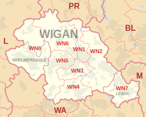
The WN postcode area, also known as the Wigan postcode area,[2] is a group of postcode districts in North West England that are sub-divisions of three post towns. It covers parts of the Greater Manchester, Merseyside and Lancashire administrative areas.
Coverage
The approximate coverage of the postcode districts:
| Postcode district | Post town | Coverage | Local authority area |
|---|---|---|---|
| WN1 | WIGAN | Haigh, Ince, Swinley, Wigan | Wigan |
| WN2 | WIGAN | Abram, Aspull, Bamfurlong, Bickershaw, Haigh, Hindley, Hindley Green, Ince, Platt Bridge | Wigan |
| WN3 | WIGAN | Goose Green, Ince, Winstanley, Worsley Mesnes, Hawkley Hall | Wigan |
| WN4 | WIGAN | Ashton-in-Makerfield, Garswood | Wigan, St Helens |
| WN5 | WIGAN | Billinge, Newtown, Higher End, Orrell, Pemberton, Winstanley, Worsley Hall, Marsh Green. | Wigan, St Helens |
| WN6 | WIGAN | Appley Bridge, Shevington, Standish, Standish Lower Ground, Wrightington | Wigan, West Lancashire |
| WN7 | LEIGH | Hope Carr, Landside, Leigh, Low Common, Bedford, Westleigh, Pennington, Higher Folds | Wigan |
| WN8 | SKELMERSDALE, WIGAN | Chapel House, Dalton, Holland Moor, Newburgh, Parbold, Roby Mill, Skelmersdale, Southway, Upholland | West Lancashire |
Map
See also
References
- ↑ "ONS Postcode Directory Version Notes" (ZIP). National Statistics Postcode Products. Office for National Statistics. February 2012. Table 2. Retrieved 21 April 2012. Coordinates from mean of unit postcode points, "Code-Point Open". OS OpenData. Ordnance Survey. February 2012. Retrieved 21 April 2012.
- ↑ Royal Mail, Address Management Guide, (2004)
External links
This article is issued from Wikipedia - version of the 8/1/2016. The text is available under the Creative Commons Attribution/Share Alike but additional terms may apply for the media files.