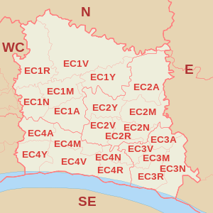
EC postcode area
Postcode district boundaries: Bing / Google
| London EC postcode area | |
|---|---|
 EC | |
| Postcode area | EC |
| Postcode area name | London EC |
| Post towns | 1 |
| Postcode districts | 30 |
| Postcode sectors | 140 |
| Postcodes (live) | 4,417 |
| Postcodes (total) | 12,243 |
| Statistics as at February 2012[1] | |
The EC (Eastern Central) postcode area, also known as the London EC postal area,[2] is a group of postcode districts in central London, England. It includes almost all of the City of London and parts of the London Boroughs of Islington, Camden, Hackney, Tower Hamlets and Westminster. The area covered is of very high density development. Deliveries for the EC postcode area are made from Mount Pleasant Mail Centre.
Postal administration
The current postcode districts are relatively recent divisions of the EC1, EC2, EC3 and EC4 districts established in 1917. Where the districts are used for purposes other than the sorting of mail, such as use as a geographic reference and on street signs, they continue to be commonly grouped into these four 'districts'.
List of postcode districts
| Postcode district | Post town | Coverage | Local authority area |
|---|---|---|---|
| EC1A | LONDON | St Bartholomew's Hospital | City of London, Islington |
| EC1M | LONDON | Clerkenwell, Farringdon | Islington, Camden, City of London |
| EC1N | LONDON | Hatton Garden | Camden, City of London |
| EC1P | LONDON | Non-geographic postcode district | |
| EC1R | LONDON | Finsbury, Finsbury Estate (west) | Islington, Camden |
| EC1V | LONDON | Finsbury (east), Moorfields Eye Hospital | Islington, Hackney |
| EC1Y | LONDON | St Luke's, Bunhill Fields | Islington, City of London |
| EC2A | LONDON | Shoreditch | Islington, Hackney, City of London |
| EC2M | LONDON | Broadgate, Liverpool Street | Tower Hamlets, City of London |
| EC2N | LONDON | Old Broad Street, Tower 42 | City of London |
| EC2P | LONDON | Non-geographic postcode district | |
| EC2R | LONDON | Bank of England | City of London |
| EC2V | LONDON | Guildhall | City of London |
| EC2Y | LONDON | Barbican | City of London |
| EC3A | LONDON | St Mary Axe, Aldgate | City of London |
| EC3M | LONDON | Lloyd's of London, Fenchurch Street | City of London |
| EC3N | LONDON | Tower Hill, Tower of London | Tower Hamlets, City of London |
| EC3P | LONDON | Non-geographic postcode district | |
| EC3R | LONDON | Monument, Billingsgate | City of London |
| EC3V | LONDON | Cornhill, Gracechurch Street, Lombard Street | City of London |
| EC4A | LONDON | Fetter Lane | City of London, Westminster |
| EC4M | LONDON | St Paul's | City of London |
| EC4N | LONDON | Mansion House | City of London |
| EC4P | LONDON | Non-geographic postcode district | |
| EC4R | LONDON | Cannon Street | City of London |
| EC4V | LONDON | Blackfriars | City of London |
| EC4Y | LONDON | Temple | City of London, Westminster |
| EC50 | LONDON | Non-geographic postcode district |
Boundaries
EC1
The EC1 postcode district (51°31′23″N 0°05′31″W / 51.523°N 0.092°W) is roughly bounded by City Road to the north, Aldersgate Street to the east, Chiswell Street and Newgate Street to the south, and Rosebery Avenue to the west. A long thin protrusion to the north east takes in all of Old Street. Taking in the districts of Clerkenwell, Finsbury and the northwestern corner of the City of London from St Paul's Cathedral.[3]
EC2
The EC2 postcode district (51°31′05″N 0°05′02″W / 51.518°N 0.084°W) is roughly bounded by Old Street to the north, Bishopsgate to the east, Cheapside, Poultry and Threadneedle Street to the south, and Aldersgate to the west. The postcode district includes Moorgate, Finsbury Circus and Liverpool Street and roughly covers the northeastern corner of the City of London from St Paul's Cathedral. To the north there are small sections in the London Borough of Islington and the London Borough of Hackney. Numbers 250-288 Bishopsgate (EC2M) fall within the London Borough of Tower Hamlets[4]
EC3
The EC3 postcode district (51°30′29″N 0°04′34″W / 51.508°N 0.076°W) is roughly bounded by Minories and the Tower of London to the east, the River Thames to the south, London Bridge and Threadneedle Street to the west and Houndsditch to the north. It includes the Monument, Aldgate, Cornhill, Fenchurch Street, Gracechurch Street, Leadenhall Street, Lombard Street, Mincing Lane, Pudding Lane and Tower Hill and roughly covers the southeastern corner of the City of London. A small part is in the London Borough of Tower Hamlets, including the Tower of London.[5]
EC4
The EC4 postcode district (51°30′40″N 0°05′53″W / 51.511°N 0.098°W) is roughly bounded by Cheapside to the north, London Bridge to the east, the River Thames to the south and Chancery Lane to the west. It roughly covers the southwestern corner of the City of London, including Fleet Street, Temple, Blackfriars, and St Paul's Cathedral. 6 postcodes in EC4 (2 in EC4A and 4 in EC4Y) fall within St. James's ward in Westminster.[6]
Map
See also
References
- ↑ "ONS Postcode Directory Version Notes" (ZIP). National Statistics Postcode Products. Office for National Statistics. February 2012. Table 2. Retrieved 21 April 2012. Coordinates from mean of unit postcode points, "Code-Point Open". OS OpenData. Ordnance Survey. February 2012. Retrieved 21 April 2012.
- ↑ Royal Mail (2004). Address Management Guide (4 ed.). Royal Mail Group.
- ↑ "EC1". The Postcodes Project. Museum of London. Archived from the original on 26 September 2012. Retrieved 23 March 2010.
- ↑ "EC2". The Postcodes Project. Museum of London. Archived from the original on 26 September 2012. Retrieved 23 March 2010.
- ↑ "EC3". The Postcodes Project. Museum of London. Archived from the original on 2 January 2013. Retrieved 23 March 2010.
- ↑ "EC4". The Postcodes Project. Museum of London. Archived from the original on 27 September 2012. Retrieved 23 March 2010.