LE postcode area

Postcode district boundaries: Bing / Google

KML is from Wikidata
Leicester postcode area
LE
Postcode area LE
Postcode area name Leicester
Post towns 12
Postcode districts 28
Postcode sectors 152
Postcodes (live) 21,602
Postcodes (total) 32,702
Statistics as at February 2012[1]

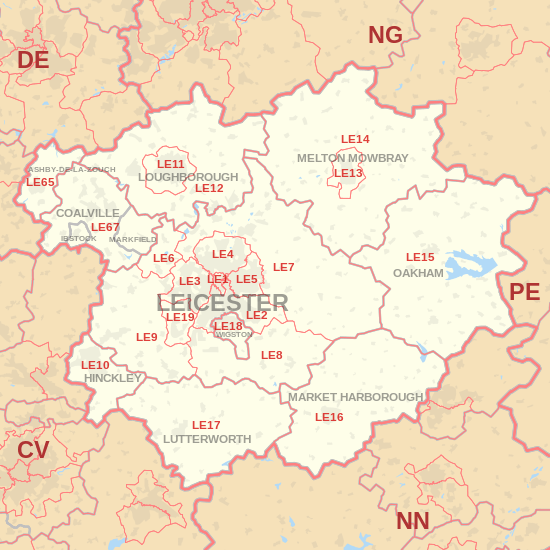
The LE postcode area, also known as the Leicester postcode area,[2] is a group of postcode districts around Coalville, Hinckley, Leicester, Loughborough, Lutterworth, Market Harborough, Oakham, Melton Mowbray and Wigston in Leicestershire, Rutland and Nottinghamshire in central England.

Coverage

The approximate coverage of the postcode districts:

Postcode district Post town Coverage Local authority area
LE1 LEICESTER Leicester Leicester
LE2 LEICESTER Oadby, Knighton, Highfields, Aylestone, Glen Parva, Stoughton, Little Stretton Leicester, Oadby and Wigston, Harborough, Blaby
LE3 LEICESTER Braunstone, Glenfield, New Parks, Groby Road (A50), Leicester Forest East, Westcotes Leicester, Blaby
LE4 LEICESTER Beaumont Leys, Belgrave, Birstall, Thurmaston Leicester, Charnwood
LE5 LEICESTER Hamilton, Thurnby Lodge, Evington Leicester
LE6 LEICESTER Ratby, Groby, Newtown Linford Hinckley and Bosworth, Charnwood
LE7 LEICESTER Scraptoft, Anstey, Billesdon, Gaddesby, Hungarton, Rearsby, Tilton on the Hill, Tugby, Cropston, Thurcaston, Rothley, Barkby, Syston, Wanlip Charnwood, Harborough, Melton
LE8 LEICESTER Blaby, Great Glen, Fleckney, Kibworth, Peatling Magna, Countesthorpe, Whetstone
LE9 LEICESTER Kirby Muxloe, Stoney Stanton, Cosby, Huncote, Croft, Desford, Newbold Verdon, Kirkby Mallory, Earl Shilton, Barwell, Sapcote, Sutton in the Elms, Broughton Astley, Thurlaston
LE10 HINCKLEY Hinckley, Burbage, Wolvey, Sharnford, Aston Flamville, Copston Magna Hinckley and Bosworth, Blaby, Rugby
LE11 LOUGHBOROUGH Loughborough, Nanpantan Charnwood
LE12 LOUGHBOROUGH East Leake, West Leake, Sutton Bonington, Long Whatton, Mountsorrel, Shepshed, Belton, Quorn, Barrow Upon Soar, Sileby, Wymeswold Charnwood, North West Leicestershire, Rushcliffe
LE13 MELTON MOWBRAY Melton Mowbray Melton
LE14 MELTON MOWBRAY Ashby Folville, Brooksby, Harby, Hickling, Hoby, Ragdale, Rotherby, Scalford, Somerby, Stonesby, Waltham on the Wolds, Wymondham Melton, Rushcliffe
LE15 OAKHAM Oakham, Cold Overton, Empingham, Knossington, Langham, Manton, Owston and Newbold, Thistleton, Uppingham, Whissendine Rutland, Melton, Harborough
LE16 MARKET HARBOROUGH Market Harborough, Arthingworth, Braybrooke, Caldecott, Clipston, East Carlton, East Farndon, East Langton, Great Oxendon, Hallaton, Marston Trussell, Medbourne, Sibbertoft Harborough, Daventry, Kettering, Corby, Rutland
LE17 LUTTERWORTH Leire, Lutterworth, Swinford, Bitteswell, Ullesthorpe, Theddingworth, Gilmorton
LE18 WIGSTON Wigston, South Wigston, Kilby Oadby and Wigston, Blaby
LE19 LEICESTER Narborough, Enderby, Littlethorpe Blaby
LE21 LEICESTER
LE41 LEICESTER Large user (otherwise in LE4) Leicester
LE55 LEICESTER
LE65 ASHBY-DE-LA-ZOUCH Ashby-de-la-Zouch, Boundary, Calke, Smisby, Willesley, Worthington North West Leicestershire, South Derbyshire
LE67 COALVILLE, IBSTOCK (LE67 6), MARKFIELD (LE67 9) North West Leicestershire, Hinckley and Bosworth, Charnwood
LE87 LEICESTER
LE94 LEICESTER
LE95 LEICESTER

The LE19 district was formed in 2002 from parts of the LE3 and LE9 districts.[3]

Map

KML is from Wikidata
LE postcode area map, showing postcode districts, post towns and neighbouring postcode areas. CV postcode area DE postcode area NG postcode area NN postcode area PE postcode area
LE postcode area map, showing postcode districts in red and post towns in grey text, with links to nearby CV, DE, NG, NN and PE postcode areas.

See also

References

  1. "ONS Postcode Directory Version Notes" (ZIP). National Statistics Postcode Products. Office for National Statistics. February 2012. Table 2. Retrieved 21 April 2012. Coordinates from mean of unit postcode points, "Code-Point Open". OS OpenData. Ordnance Survey. February 2012. Retrieved 21 April 2012.
  2. Royal Mail, Address Management Guide, (2004)
  3. "Royal Mail Update 34". Beacon Dodsworth. Retrieved 22 October 2016.

External links

This article is issued from Wikipedia - version of the 10/22/2016. The text is available under the Creative Commons Attribution/Share Alike but additional terms may apply for the media files.