M postcode area
Postcode district boundaries: Bing / Google
| Manchester postcode area | |
|---|---|
 M | |
| Postcode area | M |
| Postcode area name | Manchester |
| Post towns | 3 |
| Postcode districts | 48 |
| Postcode sectors | 302 |
| Postcodes (live) | 31,670 |
| Postcodes (total) | 56,617 |
| Statistics as at February 2012[1] | |
The M postcode area, also known as the Manchester postcode area,[2] is a group of several postcode districts in Greater Manchester, England.
The Manchester Post Town includes parts of all boroughs in Greater Manchester. The area is divided into ten post towns: Manchester, Salford, Sale, Oldham, Tameside, Stockport, Rochdale, Bury, Wigan and Bolton. The Manchester and Salford post towns form most of the area, and the other eight post towns are enclaves within it.
The entirety of the metropolitan district of the City of Manchester itself is included within the area, except for Ringway, which is in WA15. The postcode area includes nearly all of the City of Salford, most of the borough of Trafford, and small parts of the wider Greater Manchester area historically closest to the city of Manchester.
Coverage
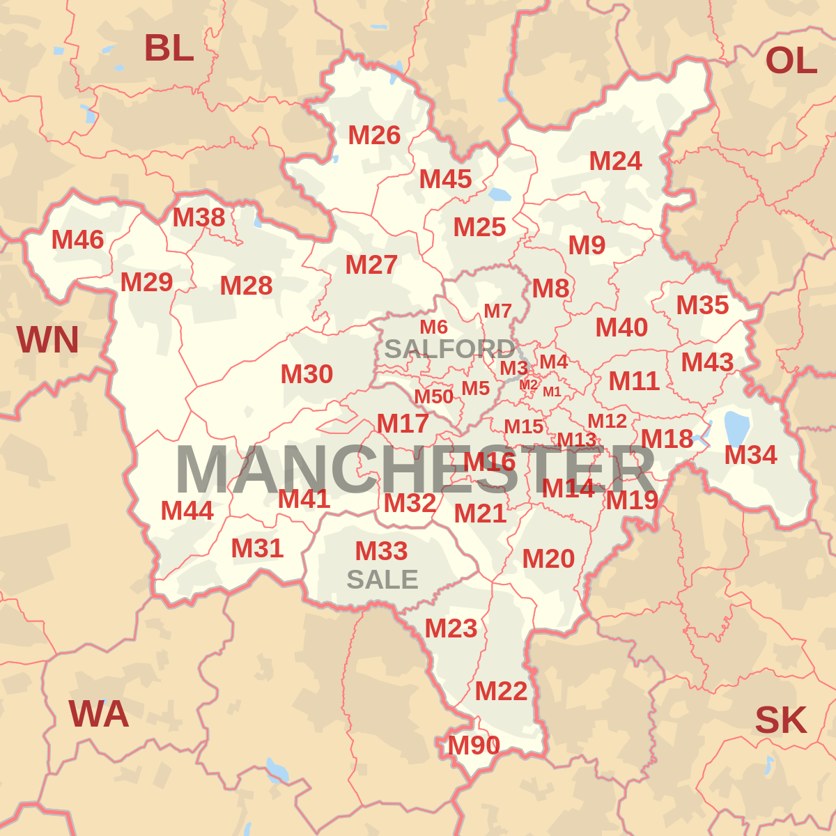
The approximate coverage of the postcode districts:
| Postcode district | Post town | Coverage | Local authority area |
|---|---|---|---|
| M1 | MANCHESTER | Piccadilly, City Centre, Market Street | Manchester |
| M2 | MANCHESTER | Deansgate, City Centre | Manchester |
| M3 (Sectors 1, 2, 3, 4 and 9) |
MANCHESTER | City Centre, Deansgate, Castlefield | Manchester |
| M3 (Sectors 5, 6 and 7) |
SALFORD | Blackfriars, Greengate, Trinity | Salford |
| M4 | MANCHESTER | Ancoats, Northern Quarter, Strangeways | Manchester |
| M5 | SALFORD | Ordsall, Seedley, Weaste, University, | Salford |
| M6 | SALFORD | Pendleton, Irlams o' th' Height, Langworthy, Seedley, Charlestown | Salford |
| M7 | SALFORD | Higher Broughton, Cheetwood, Lower Broughton, Kersal | Salford |
| M8 | MANCHESTER | Crumpsall, Cheetham Hill | Manchester |
| M9 | MANCHESTER | Harpurhey, Blackley | Manchester |
| M11 | MANCHESTER | Clayton, Openshaw, Beswick | Manchester |
| M12 | MANCHESTER | Ardwick, Longsight, Chorlton-on-Medlock | Manchester |
| M13 | MANCHESTER | Ardwick, Longsight, Chorlton-on-Medlock | Manchester |
| M14 | MANCHESTER | Fallowfield, Moss Side, Ladybarn, Rusholme, Victoria Park | Manchester |
| M15 | MANCHESTER | Hulme, Manchester Science Park | Manchester |
| M16 | MANCHESTER | Firswood, Old Trafford, Whalley Range, Moss Side | Manchester, Trafford |
| M17 | MANCHESTER | Trafford Park, The Trafford Centre | Trafford |
| M18 | MANCHESTER | Abbey Hey, Gorton | Manchester |
| M19 | MANCHESTER | Levenshulme, Burnage, Heaton Mersey, Heaton Chapel, Reddish | Manchester, Stockport |
| M20 | MANCHESTER | Didsbury, Withington | Manchester |
| M21 | MANCHESTER | Chorlton-cum-Hardy, Barlow Moor | Manchester |
| M22 | MANCHESTER | Wythenshawe, Northenden, Sharston Industrial Area | Manchester |
| M23 | MANCHESTER | Baguley, Brooklands, Roundthorn Industrial Estate | Manchester |
| M24 | MANCHESTER | Middleton, Alkrington, Chadderton | Rochdale, Oldham |
| M25 | MANCHESTER | Prestwich, Sedgeley Park, Simister | Bury |
| M26 | MANCHESTER | Radcliffe, Stoneclough | Bury, Bolton |
| M27 | MANCHESTER | Swinton, Clifton, Pendlebury, Wardley, Agecroft | Salford |
| M28 | MANCHESTER | Worsley, Walkden, Boothstown, Mosley Common, Wardley Industrial Estate | Salford, Wigan |
| M29 | MANCHESTER | Tyldesley, Astley | Wigan |
| M30 | MANCHESTER | Eccles, Monton, Peel Green, Winton, Patricroft, Barton-upon-Irwell, Ellesmere Park | Salford |
| M31 | MANCHESTER | Carrington, Partington | Trafford |
| M32 | MANCHESTER | Stretford | Trafford |
| M33 | SALE | Sale, Brooklands | Trafford |
| M34 | MANCHESTER | Denton, Audenshaw | Tameside |
| M35 | MANCHESTER | Failsworth | Oldham |
| M38 | MANCHESTER | Little Hulton | Salford |
| M40 | MANCHESTER | Collyhurst, Miles Platting, Moston, New Moston, Newton Heath | Manchester |
| M41 | MANCHESTER | Urmston, Davyhulme, Flixton, Barton Dock Road | Trafford |
| M43 | MANCHESTER | Droylsden | Tameside |
| M44 | MANCHESTER | Irlam, Cadishead | Salford |
| M45 | MANCHESTER | Whitefield | Bury |
| M46 | MANCHESTER | Atherton | Wigan |
| M50 | SALFORD | Salford Quays, MediaCityUK | Salford |
| M60 (Sectors 1 and 7) |
MANCHESTER | Large user and PO Box (located geographically in M1) | Manchester |
| M60 (Sectors 2 and 8) |
MANCHESTER | Large user and PO Box (located geographically in M2) | Manchester |
| M60 (Sectors 3 and 9) |
MANCHESTER | Large user and PO Box (located geographically in M3) | Manchester |
| M60 (Sectors 4 and 0) |
MANCHESTER | Large user and PO Box (located geographically in M4) | Manchester |
| M60 (Sectors 5 and 6) |
MANCHESTER | Manchester X | Manchester |
| M60 (Sector 9) |
SALFORD | Large user and PO Box | Salford |
| M61 | MANCHESTER | Manchester X | Manchester |
| M90 | MANCHESTER | Manchester Airport | Manchester |
| M99 | MANCHESTER | Manchester X; JD Williams (located geographically in M1 and M3) | Manchester |
Note: The original M10 postcode is obsolete, having been re-coded as M40 in 1993. The ITV soap opera Coronation Street is set in the fictional town of Weatherfield, and use M10 as their supposed postcode - for example the garage owned by Kevin Webster and Tyrone Dobbs shows an M10 postcode as their address on the sign.
Map
Former scheme
Before the introduction of postcodes in the 1960s, Manchester along with other major cities like Birmingham, Liverpool and Sheffield was divided into numbered postcode districts. With a few exceptions these were directly incorporated into the outcode (the first part of the postcode). The districts were based on Manchester and Salford together and districts outside the city boundaries were also included.
For example, the City Centre had postcode districts 1 - 4 (north-east, south, west and north-west respectively: Manchester 1 was around Piccadilly and 4 was around Victoria). 5, 6, 7 and 8 were in Salford and then the sequence continued across north Manchester and so round to M17 (Trafford Park). M18 onwards were further out still.
See also
References
- ↑ "ONS Postcode Directory Version Notes" (ZIP). National Statistics Postcode Products. Office for National Statistics. February 2012. Table 2. Retrieved 21 April 2012. Coordinates from mean of unit postcode points, "Code-Point Open". OS OpenData. Ordnance Survey. February 2012. Retrieved 21 April 2012.
- ↑ Royal Mail Address Management Guide Edition 4, (2004)
External links
- Royal Mail's Postcode Address File
- A quick introduction to Royal Mail's Postcode Address File (PAF)
- Map of postcodes of Greater Manchester