ME postcode area
Postcode district boundaries: Bing / Google
| Rochester postcode area | |
|---|---|
 ME | |
| Postcode area | ME |
| Postcode area name | Rochester |
| Post towns | 11 |
| Postcode districts | 21 |
| Postcode sectors | 83 |
| Postcodes (live) | 16,005 |
| Postcodes (total) | 20,834 |
| Statistics as at February 2012[1] | |
The ME postcode area, also known as the Rochester postcode area,[2] is a group of twenty postcode districts around Medway in Kent, England, which is where the letters in the postcode are derived from. The area is divided into eleven post towns and extends into the districts of Tonbridge and Malling, Swale, Gravesham and Maidstone, as well as the entire Unitary authority of Medway.
Coverage
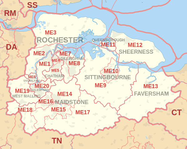
The approximate coverage of the postcode districts:
| Postcode district | Post town | Coverage | Local authority area |
|---|---|---|---|
| ME1 | ROCHESTER | Rochester, Burham, Wouldham | Medway |
| ME2 | ROCHESTER | Strood, Halling, Cuxton, Frindsbury | Medway |
| ME3 | ROCHESTER | Rural, Hoo St Werburgh | Medway, Gravesham |
| ME4 | CHATHAM | Chatham | Medway |
| ME5 | CHATHAM | Walderslade, Blue Bell Hill, Lordswood, Luton | Medway (and smaller areas within Maidstone & Tonbridge and Malling) |
| ME6 | SNODLAND | Snodland | Tonbridge and Malling |
| ME7 | GILLINGHAM | Gillingham, Rainham, Hempstead | Medway |
| ME8 | GILLINGHAM | Rainham, Parkwood, Twydall | Medway |
| ME9 | SITTINGBOURNE | Sittingbourne, Teynham, Iwade and Rural | Swale |
| ME10 | SITTINGBOURNE | Kemsley, Milton Regis | Swale |
| ME11 | QUEENBOROUGH | Queenborough, Rushenden | Swale |
| ME12 | SHEERNESS | Isle of Sheppey, Minster, Sheerness, Eastchurch | Swale |
| ME13 | FAVERSHAM | Faversham, Boughton under Blean, Selling and rural area | Swale |
| ME14 | MAIDSTONE | Maidstone, Bearsted, Grove Green | Maidstone |
| ME15 | MAIDSTONE | Bearsted (Madginford), Downswood, Shepway, Senacre, Maidstone Town Centre, Loose, Mangravet, Park Wood, Tovil, East Farleigh, West Farleigh | Maidstone |
| ME16 | MAIDSTONE | Barming, Allington and west Maidstone | Maidstone |
| ME17 | MAIDSTONE | Hollingbourne, Hucking, Harrietsham, Lenham, Boughton Monchelsea, Linton, Coxheath, Chart Sutton, East Sutton, Langley, Kingswood, Sutton Valence | Maidstone |
| ME18 | MAIDSTONE | Wateringbury, Mereworth, Teston, Nettlestead, West Peckham, Yalding, Laddingford | Maidstone, Tonbridge and Malling |
| ME19 | WEST MALLING | West Malling, Kings Hill, Leybourne | Tonbridge and Malling |
| ME20 | AYLESFORD | Aylesford, Ditton | Tonbridge and Malling |
| ME99 | ROCHESTER | Jobcentre Plus | non-geographic |
Map
See also
References
- ↑ "ONS Postcode Directory Version Notes" (ZIP). National Statistics Postcode Products. Office for National Statistics. February 2012. Table 2. Retrieved 21 April 2012. Coordinates from mean of unit postcode points, "Code-Point Open". OS OpenData. Ordnance Survey. February 2012. Retrieved 21 April 2012.
- ↑ Royal Mail, Address Management Guide, (2004)
External links
This article is issued from Wikipedia - version of the 9/29/2016. The text is available under the Creative Commons Attribution/Share Alike but additional terms may apply for the media files.