PO postcode area
Postcode district boundaries: Bing / Google
| Portsmouth postcode area | |
|---|---|
 PO | |
| Postcode area | PO |
| Postcode area name | Portsmouth |
| Post towns | 24 |
| Postcode districts | 34 |
| Postcode sectors | 130 |
| Postcodes (live) | 23,806 |
| Postcodes (total) | 31,316 |
| Statistics as at February 2012[1] | |
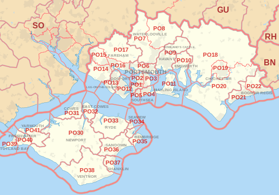
The PO postcode area, also known as the Portsmouth postcode area,[2] is a group of postcode districts around Bembridge, Bognor Regis, Chichester, Cowes, East Cowes, Emsworth, Fareham, Freshwater, Gosport, Havant, Hayling Island, Lee-on-the-Solent, Newport, Portsmouth, Rowland's Castle, Ryde, Sandown, Seaview, Shanklin, Southsea, Totland Bay, Ventnor, Waterlooville and Yarmouth in England.
Coverage
The approximate coverage of the postcode districts:
| Postcode district | Post town | Coverage | Local authority area |
|---|---|---|---|
| PO1 | PORTSMOUTH | Portsmouth, Fratton, Old Portsmouth, Portsea, Landport | Portsmouth |
| PO2 | PORTSMOUTH | Portsmouth, Hilsea, North End | Portsmouth |
| PO3 | PORTSMOUTH | Portsmouth, Hilsea, Copnor, Anchorage Park | Portsmouth |
| PO4 | SOUTHSEA | Southsea | Portsmouth |
| PO5 | SOUTHSEA | Southsea | Portsmouth |
| PO6 | PORTSMOUTH | Cosham, Drayton, Farlington | Portsmouth |
| PO7 | WATERLOOVILLE | Waterlooville, Denmead, Purbrook | Havant, Winchester |
| PO8 | WATERLOOVILLE | Clanfield, Cowplain, Horndean | Havant, East Hampshire |
| PO9 | HAVANT | Havant | Havant |
| PO9 | ROWLAND'S CASTLE | Rowland's Castle | East Hampshire, Havant |
| PO10 | EMSWORTH | Emsworth, Southbourne, Westbourne | Havant |
| PO11 | HAYLING ISLAND | Hayling Island | Havant |
| PO12 | GOSPORT | Gosport, Alverstoke, Hardway | Gosport |
| PO12 | LEE-ON-THE-SOLENT | Gosport | non-geographic[3][4] |
| PO13 | GOSPORT | Gosport | Gosport |
| PO13 | LEE-ON-THE-SOLENT | Lee-on-the-Solent | Gosport |
| PO14 | FAREHAM | Fareham, Hill Head, Stubbington, Titchfield | Fareham |
| PO15 | FAREHAM | Fareham, Titchfield, Whiteley | Fareham |
| PO16 | FAREHAM | Portchester | Fareham |
| PO17 | FAREHAM | Wickham | Fareham |
| PO18 | CHICHESTER | Bosham, Boxgrove, Eartham, East Dean, Goodwood, Funtington, Nutbourne | Chichester |
| PO19 | CHICHESTER | Chichester, Fishbourne | Chichester |
| PO20 | CHICHESTER | Selsey, West Wittering, East Wittering, Tangmere, Oving, Westergate, Eastergate | Chichester |
| PO21 | BOGNOR REGIS | Bognor Regis, Aldwick, Pagham | Arun |
| PO22 | BOGNOR REGIS | Bognor Regis, Barnham, Elmer, Felpham, Middleton-on-Sea | Arun |
| PO30 | NEWPORT | Isle of Wight | |
| PO30 | YARMOUTH | non-geographic[3][4] | |
| PO31 | COWES | Cowes, Gurnard | Isle of Wight |
| PO32 | EAST COWES | East Cowes, Whippingham | Isle of Wight |
| PO33 | RYDE | Isle of Wight | |
| PO34 | SEAVIEW | Seaview | Isle of Wight |
| PO35 | BEMBRIDGE | Bembridge, Whitecliff Bay | Isle of Wight |
| PO36 | SANDOWN | Isle of Wight | |
| PO36 | SHANKLIN | non-geographic[3][4] | |
| PO37 | SHANKLIN | Isle of Wight | |
| PO38 | VENTNOR | Isle of Wight | |
| PO39 | TOTLAND BAY | Totland Bay, Alum Bay | Isle of Wight |
| PO40 | FRESHWATER | Freshwater | Isle of Wight |
| PO41 | YARMOUTH | Isle of Wight |
Map
See also
References
- ↑ "ONS Postcode Directory Version Notes" (ZIP). National Statistics Postcode Products. Office for National Statistics. February 2012. Table 2. Retrieved 21 April 2012. Coordinates from mean of unit postcode points, "Code-Point Open". OS OpenData. Ordnance Survey. February 2012. Retrieved 21 April 2012.
- ↑ Royal Mail, Address Management Guide, (2004)
- 1 2 3 "Non Geographic Codes" (PDF). Royal Mail Address Management Unit. July 2012. Retrieved 25 October 2012.
- 1 2 3 "New sectors and localities to 19 October 2012" (PDF). Royal Mail Address Management Unit. 19 October 2012. Retrieved 25 October 2012.
External links
This article is issued from Wikipedia - version of the 11/3/2016. The text is available under the Creative Commons Attribution/Share Alike but additional terms may apply for the media files.