CV postcode area
Postcode district boundaries: Bing / Google
| Coventry postcode area | |
|---|---|
 CV | |
| Postcode area | CV |
| Postcode area name | Coventry |
| Post towns | 11 |
| Postcode districts | 24 |
| Postcode sectors | 104 |
| Postcodes (live) | 19,547 |
| Postcodes (total) | 26,648 |
| Statistics as at February 2012[1] | |
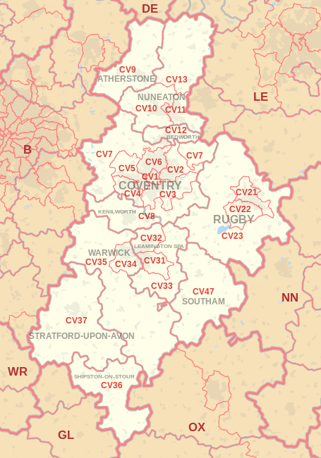
The CV postcode area, also known as the Coventry postcode area,[2] is a group of postcode districts around Atherstone, Bedworth, Coventry, Kenilworth, Leamington Spa, Nuneaton, Rugby, Shipston-on-Stour, Southam, Stratford-upon-Avon and Warwick in England.
Postal districts CV1 to CV6 covers the city of Coventry and its immediate suburban areas, while districts CV7 to CV47 covers all towns, villages and rural areas beyond the city itself. A number of suburban villages in the CV6 area lie within neighbouring Warwickshire, including Hawkesbury Village and Neals Green. Coventry remains the post town for the CV7 district, even though large villages such as Balsall Common and Meriden lie within the Solihull Metropolitan district and are several miles west of the city, very close to the Birmingham postcode area.
The CV postcode area is relatively extensive (especially north to south) and borders the postcode areas of Birmingham (B) to the west/northwest/southwest, Leicester (LE) to the northeast, Derby (DE) to the north, Northampton (NN) to the southeast, Gloucester (GL) and Worcester (WR) to the southwest, and Oxford (OX) to the south.
Coverage
The approximate coverage of the postcode districts:
| Postcode district | Post town | Coverage | Local authority area |
|---|---|---|---|
| CV1 | COVENTRY | Coventry C (Coventry City Centre, Gosford Green, Hillfields, Spon End, Coventry University) | Coventry |
| CV2 | COVENTRY | Coventry NE (Walsgrave, Wyken, Stoke, Bell Green, Wood End, Potters Green, Aldermans Green, Clifford Park, Woodway Park) | Coventry |
| CV3 | COVENTRY | Coventry SE (Binley, Whitley, Willenhall, Cheylesmore, Styvechale, Finham, Fenside, Stoke Aldermoor, Green Lane, Ernesford Grange, Binley Woods) | Coventry, Rugby |
| CV4 | COVENTRY | Coventry SW (Tile Hill, Canley, Cannon Park, Lime Tree Park, Gibbet Hill, Westwood Heath, University of Warwick) | Coventry |
| CV5 | COVENTRY | Coventry NW (Allesley, Allesley Park, Allesley Green, Earlsdon, Eastern Green, Whoberley, Chapelfields, Mount Nod, Brownshill Green) | Coventry |
| CV6 | COVENTRY | Coventry N (Holbrooks, Coundon, Radford, Longford, Rowley's Green, Courthouse Green, Whitmore Park), Hawkesbury | Coventry, Nuneaton and Bedworth |
| CV7 | COVENTRY | Exhall, Ash Green, Keresley, Meriden, Balsall Common, Berkswell, Corley, Arley, Ansty, Shilton, Fillongley | Nuneaton and Bedworth, North Warwickshire, Coventry, Rugby, Solihull |
| CV8 | COVENTRY, KENILWORTH | Kenilworth, Baginton, Bubbenhall, Brandon, Stoneleigh, Wolston, Ryton-On-Dunsmore, Ashow | Warwick, Rugby |
| CV9 | ATHERSTONE | Atherstone, Mancetter, Grendon, Baddesley Ensor, Baxterley, Hurley, Witherley, Wood End, Twycross, Orton On The Hill | North Warwickshire, Hinckley and Bosworth |
| CV10 | NUNEATON | Nuneaton N & W (Weddington, Stockingford, Camp Hill, Galley Common, Grove Farm, Whittleford, Chapel End, Bermuda Village), Caldecote, Fenny Drayton, Hartshill, Ansley, Astley, Oldbury, Ridge Lane | Nuneaton and Bedworth, North Warwickshire |
| CV11 | NUNEATON | Nuneaton C & E (town centre, Abbey Green, St Nicolas Park, Horeston Grange, Attleborough, Whitestone, Hill Top, Chilvers Coton, Caldwell), Burton Hastings, Bramcote | Nuneaton and Bedworth, Rugby |
| CV12 | BEDWORTH | Bedworth (except Exhall and Ash Green), Bulkington | Nuneaton and Bedworth |
| CV13 | NUNEATON | Barlestone, Barton in the Beans, Bilstone, Cadeby, Carlton, Congerstone, Dadlington, Fenny Drayton, Higham on the Hill, Market Bosworth, Nailstone, Odstone, Osbaston, Shackerstone, Shenton, Stoke Golding, Sutton Cheney, Upton, Wellsborough | Hinckley and Bosworth |
| CV21 | RUGBY | Rugby E, Brownsover | Rugby |
| CV22 | RUGBY | Rugby SW, Hillmorton, Bilton | Rugby |
| CV23 | RUGBY | Dunchurch, Thurlaston, Princethorpe, Stretton-on-Dunsmore, Birdingbury, Brinklow, Long Lawford, Clifton upon Dunsmore, Stretton-under-Fosse, Monks Kirby, Kilsby | Rugby, Daventry |
| CV31 | LEAMINGTON SPA | Leamington Spa S, Whitnash, Radford Semele | Warwick |
| CV32 | LEAMINGTON SPA | Leamington Spa N, Cubbington, Lillington | Warwick |
| CV33 | LEAMINGTON SPA | Harbury and surrounding villages | Warwick, Stratford-on-Avon |
| CV34 | WARWICK | Warwick | Warwick |
| CV35 | WARWICK | Wellesbourne, Kineton and surrounding villages | Warwick, Stratford-on-Avon |
| CV36 | SHIPSTON-ON-STOUR | Shipston-on-Stour and surrounding villages | Stratford-on-Avon |
| CV37 | STRATFORD-UPON-AVON | Stratford-upon-Avon and surrounding villages | Stratford-on-Avon |
| CV47 | SOUTHAM | Southam and surrounding villages | Stratford-on-Avon |
Map
See also
- List of postcode areas in the United Kingdom
- Centre points of the United Kingdom
- Postcode Address File
References
- ↑ "ONS Postcode Directory Version Notes" (ZIP). National Statistics Postcode Products. Office for National Statistics. February 2012. Table 2. Retrieved 21 April 2012. Coordinates from mean of unit postcode points, "Code-Point Open". OS OpenData. Ordnance Survey. February 2012. Retrieved 21 April 2012.
- ↑ Royal Mail, Address Management Guide, (2004)