WR postcode area
Postcode district boundaries: Bing / Google
| Worcester postcode area | |
|---|---|
 WR | |
| Postcode area | WR |
| Postcode area name | Worcester |
| Post towns | 7 |
| Postcode districts | 17 |
| Postcode sectors | 50 |
| Postcodes (live) | 8,390 |
| Postcodes (total) | 11,781 |
| Statistics as at February 2012[1] | |
The WR postcode area, also known as the Worcester postcode area,[2] is a group of fifteen postcode districts in England, which are subdivisions of seven post towns. These postcode districts cover much of Worcestershire, including Worcester, Broadway, Droitwich, Evesham, Malvern, Pershore and Tenbury Wells, plus very small parts of Herefordshire, Shropshire, Warwickshire and Gloucestershire.
Coverage
The approximate coverage of the postcode districts:
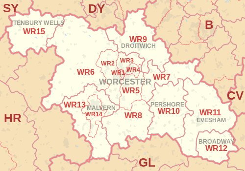
| Postcode district | Post town | Coverage | Local authority area |
|---|---|---|---|
| WR1 | WORCESTER | Worcester | Worcester |
| WR2 | WORCESTER | Powick, Hallow | Worcester, Malvern Hills |
| WR3 | WORCESTER | Fernhill Heath, Claines | Worcester, Wychavon |
| WR4 | WORCESTER | Warndon, Long Meadow | Worcester, Wychavon |
| WR5 | WORCESTER | Kempsey, Broomhall | Worcester, Wychavon, Malvern Hills |
| WR6 | WORCESTER | Martley, Clifton on Teme, Abberley | Malvern Hills, Herefordshire |
| WR7 | WORCESTER | Inkberrow, Crowle, Upton Snodsbury | Wychavon |
| WR8 | WORCESTER | Upton upon Severn, Hanley Castle, Hanley Swan | Malvern Hills, Wychavon |
| WR9 | DROITWICH | Droitwich, Ombersley, Wychbold | Wychavon, Wyre Forest |
| WR10 | PERSHORE | Pershore, Eckington, Drakes Broughton | Wychavon |
| WR11 | BROADWAY | non-geographic[3] | |
| WR11 | EVESHAM | Evesham, Harvington, Badsey | Wychavon, Stratford-on-Avon, Tewkesbury, Cotswold |
| WR12 | BROADWAY | Broadway, Willersey, Childswickham | Wychavon, Tewkesbury, Cotswold |
| WR13 | MALVERN | Colwall, Cradley, Welland | Malvern Hills, Herefordshire, Forest of Dean |
| WR14 | MALVERN | Malvern, Upper Welland | Malvern Hills, Herefordshire |
| WR15 | TENBURY WELLS | Tenbury Wells, Burford, Newnham Bridge | Malvern Hills, Shropshire, Herefordshire |
| WR78 | WORCESTER | Kays Ltd | non-geographic[4] |
| WR99 | WORCESTER | Kays Ltd | non-geographic[4] |
Map
See also
References
- ↑ "ONS Postcode Directory Version Notes" (ZIP). National Statistics Postcode Products. Office for National Statistics. February 2012. Table 2. Retrieved 21 April 2012. Coordinates from mean of unit postcode points, "Code-Point Open". OS OpenData. Ordnance Survey. February 2012. Retrieved 21 April 2012.
- ↑ Royal Mail, Address Management Guide, (2004)
- ↑ "New sectors and localities to 16 November 2012" (PDF). Royal Mail Address Management Unit. 19 November 2012. Retrieved 29 November 2012.
- 1 2 "Non Geographic Codes" (PDF). Royal Mail Address Management Unit. July 2012. Archived from the original (PDF) on September 16, 2012. Retrieved 29 November 2012.
External links
This article is issued from Wikipedia - version of the 9/9/2016. The text is available under the Creative Commons Attribution/Share Alike but additional terms may apply for the media files.