EX postcode area

Postcode district boundaries: Bing / Google

KML is from Wikidata
Exeter postcode area
EX
Postcode area EX
Postcode area name Exeter
Post towns 30
Postcode districts 33
Postcode sectors 128
Postcodes (live) 21,654
Postcodes (total) 27,084
Statistics as at February 2012[1]

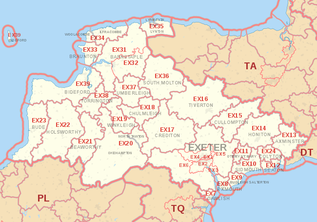
The EX postcode area, also known as the Exeter postcode area,[2] is a group of 33 postcode districts in England, which are subdivisions of 30 post towns. These postcode districts cover north and east Devon, including Exeter, Barnstaple, Axminster, Beaworthy, Bideford, Braunton, Budleigh Salterton, Chulmleigh, Colyton, Crediton, Cullompton, Dawlish, Exmouth, Holsworthy, Honiton, Ilfracombe, Lynmouth, Lynton, North Tawton, Okehampton, Ottery St Mary, Seaton, Sidmouth, Sidford, Sidbury, South Molton, Tiverton, Torrington, Umberleigh, Winkleigh and Woolacombe, plus the northernmost part of Cornwall, including Bude.

Coverage

The approximate coverage of the postcode districts:

Postcode district Post town Coverage Local authority area
EX1 EXETER Exeter (east), Heavitree (north), Monkerton, Newtown, Pinhoe, West Clyst Exeter City Council
EX2 EXETER Exeter (south), Heavitree (south), St. Thomas (south), Countess Wear, Wonford Exeter City Council
EX3 EXETER Clyst St. George, Ebford, Exton, Topsham Exeter City Council
EX4 EXETER Exeter (north), Exwick, St. Thomas (north), Beacon Heath, Redhills, Pennsylvania, St. James, Whitestone Exeter City Council
EX5 EXETER Bradninch, Broadclyst, Cadbury, Clyst Honiton, Clyst St. Mary, Cranbrook, Newton St. Cyres, Silverton, Talaton, Whimple, Woodbury East Devon & Mid Devon
EX6 EXETER Christow, Cockwood, Dunsford, Kennford, Kenton, Mamhead, Exminster Teignbridge
EX7 DAWLISH Dawlish Teignbridge
EX8 EXMOUTH Exmouth, Lympstone East Devon
EX9 BUDLEIGH SALTERTON Budleigh Salterton, East Budleigh, Otterton East Devon
EX10 SIDMOUTH Sidmouth East Devon
EX11 OTTERY ST. MARY Ottery St. Mary East Devon
EX12 SEATON Seaton, Beer, Axmouth, Branscombe East Devon
EX13 AXMINSTER Axminster East Devon
EX14 HONITON Honiton East Devon
EX15 CULLOMPTON Cullompton, Plymtree Mid Devon
EX16 TIVERTON Tiverton Mid Devon
EX17 CREDITON Crediton Mid Devon
EX18 CHULMLEIGH Chulmleigh North Devon
EX19 WINKLEIGH Winkleigh Torridge
EX20 NORTH TAWTON, OKEHAMPTON Okehampton West Devon
EX21 BEAWORTHY Beaworthy West Devon
EX22 HOLSWORTHY Holsworthy West Devon
EX23 BUDE Bude, Coombe, Crackington Haven, Launcells, Poundstock, Stratton Cornwall
EX24 COLYTON Colyton East Devon
EX31 BARNSTAPLE Barnstaple, Fremington North Devon
EX32 BARNSTAPLE North Devon
EX33 BRAUNTON Braunton North Devon
EX34 ILFRACOMBE, WOOLACOMBE Ilfracombe, Woolacombe North Devon
EX35 LYNMOUTH, LYNTON Lynmouth, Lynton North Devon
EX36 SOUTH MOLTON South Molton North Devon
EX37 UMBERLEIGH Umberleigh North Devon
EX38 TORRINGTON Great Torrington Torridge
EX39 BIDEFORD Bideford, Lundy Island Torridge

Map

KML is from Wikidata
EX postcode area map, showing postcode districts, post towns and neighbouring postcode areas. BA postcode area BS postcode area DT postcode area DT postcode area PL postcode area TA postcode area TQ postcode area
EX postcode area map, showing postcode districts in red and post towns in grey text, with links to nearby DT, PL, TA and TQ postcode areas.

See also

References

  1. "ONS Postcode Directory Version Notes" (ZIP). National Statistics Postcode Products. Office for National Statistics. February 2012. Table 2. Retrieved 21 April 2012. Coordinates from mean of unit postcode points, "Code-Point Open". OS OpenData. Ordnance Survey. February 2012. Retrieved 21 April 2012.
  2. Royal Mail, Address Management Guide, (2004)

External links

This article is issued from Wikipedia - version of the 10/12/2016. The text is available under the Creative Commons Attribution/Share Alike but additional terms may apply for the media files.