BH postcode area
Postcode district boundaries: Bing / Google
| Bournemouth postcode area | |
|---|---|
 BH | |
| Postcode area | BH |
| Postcode area name | Bournemouth |
| Post towns | 11 |
| Postcode districts | 26 |
| Postcode sectors | 103 |
| Postcodes (live) | 15,319 |
| Postcodes (total) | 21,366 |
| Statistics as at February 2012[1] | |
The BH postcode area, also known as the Bournemouth postcode area,[2] is a group of 26 postcode districts in England, which are subdivisions of eleven post towns. These postcode districts cover east Dorset and a part of west Hampshire, including Bournemouth, Poole, Broadstone, Christchurch, Ferndown, New Milton, Ringwood, Swanage, Verwood, Wareham and Wimborne.
Coverage
The approximate coverage of the postcode districts:
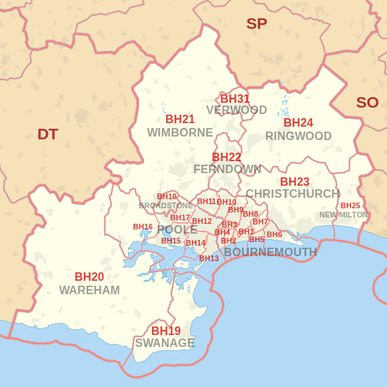
| Postcode district | Post town | Coverage | Local authority area |
|---|---|---|---|
| BH1 | BOURNEMOUTH | Town Centre, Springbourne, East Cliff, Boscombe | Bournemouth |
| BH2 | BOURNEMOUTH | Bournemouth Central, West Cliff | Bournemouth |
| BH3 | BOURNEMOUTH | Talbot Woods, Winton | Bournemouth |
| BH4 | BOURNEMOUTH | Westbourne, Branksome Woods | Bournemouth |
| BH5 | BOURNEMOUTH | Boscombe, Pokesdown | Bournemouth |
| BH6 | BOURNEMOUTH | Southbourne, Tuckton, Wick | Bournemouth |
| BH7 | BOURNEMOUTH | Littledown, Iford | Bournemouth |
| BH8 | BOURNEMOUTH | Malmesbury Park, Queens Park, Strouden Park, Townsend, Holdenhurst, Throop | Bournemouth |
| BH9 | BOURNEMOUTH | Winton, Moordown, Throop, Muscliff | Bournemouth |
| BH10 | BOURNEMOUTH | Kinson, Northbourne, Redhill, Ensbury Park, Wallisdown | Bournemouth |
| BH11 | BOURNEMOUTH | Kinson, Bear Cross, West Howe, Wallisdown | Bournemouth |
| BH12 | POOLE | Branksome, Alderney, Upper Parkstone, Wallisdown, Newtown | Poole |
| BH13 | POOLE | Canford Cliffs, Sandbanks, Branksome Park | Poole |
| BH14 | POOLE | Lower Parkstone, Lilliput, Penn Hill | Poole |
| BH15 | POOLE | Town Centre, Hamworthy, Oakdale | Poole |
| BH16 | POOLE | Upton, Turlin Moor, Lytchett Minster, Lytchett Matravers | Purbeck, Poole, East Dorset |
| BH17 | POOLE | Canford Heath, Creekmoor | Poole |
| BH18 | BROADSTONE | Broadstone | Poole |
| BH19 | SWANAGE | Swanage, Studland, Langton Matravers | Purbeck |
| BH20 | WAREHAM | Wareham, Wool, Bere Regis | Purbeck |
| BH21 | WIMBORNE | Wimborne, Corfe Mullen | East Dorset |
| BH22 | FERNDOWN | Ferndown, West Moors, West Parley | East Dorset |
| BH23 | CHRISTCHURCH | Christchurch, Mudeford, Highcliffe | Christchurch |
| BH24 | RINGWOOD | Ringwood, St Leonards, Ashley Heath | New Forest |
| BH25 | NEW MILTON | New Milton, Barton on Sea, Bashley, Wootton, Ossemsley | New Forest |
| BH31 | VERWOOD | Verwood, Three Legged Cross | East Dorset |
Map
See also
References
- ↑ "ONS Postcode Directory Version Notes" (ZIP). National Statistics Postcode Products. Office for National Statistics. February 2012. Table 2. Retrieved 21 April 2012. Coordinates from mean of unit postcode points, "Code-Point Open". OS OpenData. Ordnance Survey. February 2012. Retrieved 21 April 2012.
- ↑ Royal Mail, Address Management Guide, (2004)
External links
This article is issued from Wikipedia - version of the 7/30/2016. The text is available under the Creative Commons Attribution/Share Alike but additional terms may apply for the media files.