PR postcode area

Postcode district boundaries: Bing / Google

KML is from Wikidata
Preston postcode area
PR
Postcode area PR
Postcode area name Preston
Post towns 4
Postcode districts 13
Postcode sectors 83
Postcodes (live) 12,740
Postcodes (total) 18,862
Statistics as at February 2012[1]

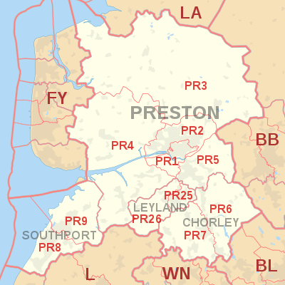
The PR postcode area, also known as the Preston postcode area,[2] is a group of eleven postcode districts in England, which are subdivisions of four post towns. These postcode districts cover the city of Preston and the towns of Leyland and Chorley in south-west Lancashire, plus the town of Southport in Merseyside.

Coverage

The approximate coverage of the postcode districts:

Postcode district Post town Coverage Local authority area
PR0 PRESTON Non-geographic postcode - Express Gifts, PR1[3] City of Preston
PR1 PRESTON City Centre, Avenham, Broadgate, Deepdale, Fishwick, St. Matthew's, Penwortham City of Preston, South Ribble
PR2 PRESTON Ashton On Ribble, Brookfield, Cadley, Fulwood, Grimsargh, Haighton, Ingol, Larches, Lea, Ribbleton, Riversway, Sharoe Green, Tanterton City of Preston
PR3 PRESTON Barnacre-with-Bonds, Barton, Bilsborrow, Bonds, Bowgreave, Broughton, Cabus, Calder Vale, Chipping, Forton, Garstang, Goosnargh, Great Eccleston, Little Eccleston, Longridge, Myerscough, Oakenclough, Pilling, Ribchester, St Michael's On Wyre, Scorton, Whittingham, Winmarleigh Fylde, City of Preston, Ribble Valley, Wyre
PR4 PRESTON Becconsall, Catforth, Clifton, Cottam, Eaves, Elswick, Freckleton, Hesketh Bank, Hutton, Inskip, Kirkham, Longton, Much Hoole, New Longton, Newton, Tarleton, Thistleton, Treales, Roseacre and Wharles, Walmer Bridge, Warton, Wesham, Woodplumpton, Wrea Green Fylde, City of Preston, South Ribble, West Lancashire
PR5 PRESTON Bamber Bridge, Coupe Green, Cuerdale, Cuerden, Gregson Lane, Higher Walton, Hoghton, Lostock Hall, Riley Green, Samlesbury, Walton-le-Dale, Walton Park, Walton Summit South Ribble, Chorley, City of Preston
PR6 CHORLEY Abbey Village, Adlington, Anderton, Anglezarke, Astley Village, Brindle, Brinscall, Clayton-le-Woods, Heapey, Heath Charnock, Wheelton, White Coppice, Whittle-le-Woods, Withnell Chorley
PR7 CHORLEY Adlington, Buckshaw Village, Charnock Richard, Coppull, Eccleston, Euxton, Heath Charnock, Heskin Chorley
PR8 SOUTHPORT Ainsdale, Birkdale, Blowick, Scarisbrick Sefton, West Lancashire
PR9 SOUTHPORT Banks, Churchtown, Crossens, Marshside Sefton, West Lancashire
PR11 PRESTON Non-geographic postcode - Great Universal Stores/Department for Work and Pensions, PR1[3] City of Preston
PR25 LEYLAND Leyland, Clayton-le-Woods, Cuerden, Farington South Ribble, Chorley
PR26 LEYLAND Leyland, Bretherton, Croston, Farington Moss, Moss Side, Ulnes Walton South Ribble, Chorley

The PR25 and PR26 districts were formed out of the PR5 district in January 2001; Leyland became a new post town at the same time (the area having previously been part of the Preston post town).[4]

Map

KML is from Wikidata
PR postcode area map, showing postcode districts, post towns and neighbouring postcode areas. BB postcode area BL postcode area FY postcode area L postcode area LA postcode area WN postcode area
PR postcode area map, showing postcode districts in red and post towns in grey text, with links to nearby BB, BL, FY, L, LA and WN postcode areas.

See also

References

  1. "ONS Postcode Directory Version Notes" (ZIP). National Statistics Postcode Products. Office for National Statistics. February 2012. Table 2. Retrieved 21 April 2012. Coordinates from mean of unit postcode points, "Code-Point Open". OS OpenData. Ordnance Survey. February 2012. Retrieved 21 April 2012.
  2. Royal Mail, Address Management Guide, (2004)
  3. 1 2 "Royal Mail non-geographic postcodes" (PDF). Royal Mail. 2007-03-07. Retrieved 2008-03-10.
  4. "Which districts have been recoded by the Royal Mail?". Experian QAS. Retrieved 22 October 2016.

External links

This article is issued from Wikipedia - version of the 10/22/2016. The text is available under the Creative Commons Attribution/Share Alike but additional terms may apply for the media files.