CA postcode area
Postcode district boundaries: Bing / Google
| Carlisle postcode area | |
|---|---|
 CA | |
| Postcode area | CA |
| Postcode area name | Carlisle |
| Post towns | 22 |
| Postcode districts | 30 |
| Postcode sectors | 83 |
| Postcodes (live) | 12,342 |
| Postcodes (total) | 15,612 |
| Statistics as at February 2012[1] | |
The CA postcode area, also known as the Carlisle postcode area,[2] is a group of postcode districts around Alston, Appleby-in-Westmorland, Beckermet, Brampton, Carlisle, Cleator, Cleator Moor, Cockermouth, Egremont, Frizington, Holmrook, Keswick, Kirkby Stephen, Maryport, Moor Row, Penrith, Ravenglass, Seascale, St Bees, Whitehaven, Wigton and Workington in England.
Coverage
The approximate coverage of the postcode districts:
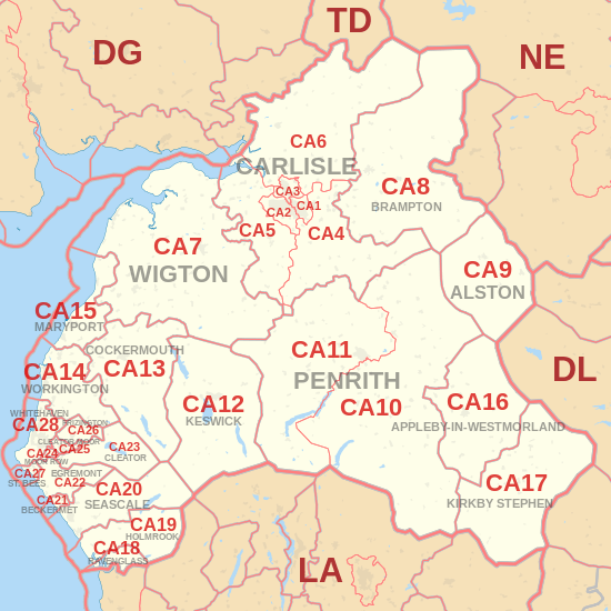
| Postcode district | Post town | Coverage | Local authority area |
|---|---|---|---|
| CA1 | CARLISLE | Carlisle East | City of Carlisle |
| CA2 | CARLISLE | Carlisle South West | City of Carlisle |
| CA3 | CARLISLE | Carlisle North | City of Carlisle |
| CA4 | CARLISLE | Warwick Bridge, Wetheral, Cumwhinton & Armathwaite | City of Carlisle, Eden |
| CA5 | CARLISLE | Dalston and Burgh by Sands | City of Carlisle, Allerdale |
| CA6 | CARLISLE | Longtown, Bewcastle | City of Carlisle |
| CA7 | WIGTON; CARLISLE | Wigton, Silloth, Aspatria, Caldbeck & Hesket Newmarket | Allerdale, Eden |
| CA8 | BRAMPTON; CARLISLE | Brampton, Gilsland, Greenhead & Slaggyford | City of Carlisle, Northumberland (unitary) |
| CA9 | ALSTON | Alston, Garrigill & Nenthead | Eden, Northumberland |
| CA10 | PENRITH | Penrith Carleton Hall area, Shap, Tebay, Kirkby Thore, Langwathby, Lazonby & Pooley Bridge | Eden, South Lakeland |
| CA11 | PENRITH | Penrith (most), Stainton, Mungrisdale, Glenridding & Patterdale | Eden |
| CA12 | KESWICK | Keswick, Seatoller, Braithwaite, Bassenthwaite & Threlkeld | Allerdale, Eden |
| CA13 | COCKERMOUTH | Cockermouth, Lorton & Buttermere | Allerdale |
| CA14 | WORKINGTON | Workington, Distington, Stainburn & Seaton | Allerdale, Copeland |
| CA15 | MARYPORT | Maryport, Dearham, Flimby & Allonby | Allerdale |
| CA16 | APPLEBY-IN-WESTMORLAND | Appleby-in-Westmorland | Eden |
| CA17 | KIRKBY STEPHEN | Kirkby Stephen, Brough & Ravenstonedale | Eden, South Lakeland |
| CA18 | RAVENGLASS | Ravenglass | Copeland |
| CA19 | HOLMROOK | Holmrook, Santon Bridge & Eskdale | Copeland |
| CA20 | SEASCALE | Seascale, Sellafield, Gosforth & Wasdale Head | Copeland |
| CA21 | BECKERMET | Beckermet | Copeland |
| CA22 | EGREMONT | Egremont & Thornhill | Copeland |
| CA23 | CLEATOR | Ennerdale Bridge | Copeland |
| CA24 | MOOR ROW | Moor Row | Copeland |
| CA25 | CLEATOR MOOR | Cleator Moor | Copeland |
| CA26 | FRIZINGTON | Frizington & Croasdale | Copeland |
| CA27 | ST. BEES | St. Bees | Copeland |
| CA28 | WHITEHAVEN | Whitehaven, Sandwith & Hensingham | Copeland |
| CA95 | WORKINGTON | non-geographic | Allerdale |
| CA99 | CARLISLE | Jobcentre Plus | non-geographic |
Map
See also
References
- ↑ "ONS Postcode Directory Version Notes" (ZIP). National Statistics Postcode Products. Office for National Statistics. February 2012. Table 2. Retrieved 21 April 2012. Coordinates from mean of unit postcode points, "Code-Point Open". OS OpenData. Ordnance Survey. February 2012. Retrieved 21 April 2012.
- ↑ Royal Mail, Address Management Guide, (2004)
External links
This article is issued from Wikipedia - version of the 11/20/2016. The text is available under the Creative Commons Attribution/Share Alike but additional terms may apply for the media files.