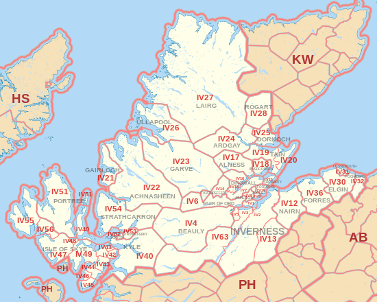
IV postcode area
Postcode district boundaries: Bing / Google
| Inverness postcode area | |
|---|---|
 IV | |
| Postcode area | IV |
| Postcode area name | Inverness |
| Post towns | 31 |
| Postcode districts | 53 |
| Postcode sectors | 84 |
| Postcodes (live) | 7,099 |
| Postcodes (total) | 10,256 |
| Statistics as at February 2012[1] | |
The IV postcode area, also known as the Inverness postcode area,[2] is a group of postcode districts around Achnasheen, Alness, Avoch, Beauly, Bonar Bridge, Cromarty, Dingwall, Dornoch, Elgin, Fochabers, Forres, Fortrose, Gairloch, Garve, Glen Shiel, Invergordon, Inverness, Isle of Skye, Kyle, Lairg, Lossiemouth, Muir of Ord, Munlochy, Nairn, Plockton, Portree, Rogart, Strathcarron, Strathpeffer, Strome Ferry, Tain and Ullapool in Scotland.
Coverage
The approximate coverage of the postcode districts:
| Postcode district | Post town | Coverage | Local authority area |
|---|---|---|---|
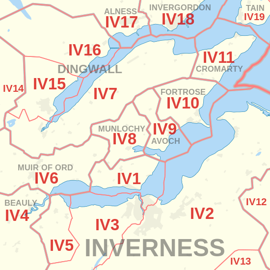
| IV1 | INVERNESS | Inverness centre and north, including the Longman, plus North Kessock and Kilmuir | Highland |
| IV2 | INVERNESS | Inverness east, plus Culloden, Balloch and Ardersier | Highland |
| IV3 | INVERNESS | Inverness west, plus Dochgarroch, Abriachan and Bunchrew | Highland |
| IV4 | BEAULY | Beauly, Kiltarlity, Struy, Cannich, Tomich | Highland |
| IV5 | INVERNESS | Kirkhill, Inchmore, Moniack and Cabrich | Highland |
| IV6 | MUIR OF ORD | Muir of Ord, Marybank, Strathconon | Highland |
| IV7 | DINGWALL | Conon Bridge, Culbokie, Maryburgh | Highland |
| IV8 | MUNLOCHY | Munlochy | Highland |
| IV9 | AVOCH | Avoch | Highland |
| IV10 | FORTROSE | Fortrose | Highland |
| IV11 | CROMARTY | Cromarty | Highland |
| IV12 | NAIRN | Auldearn | Highland |
| IV13 | INVERNESS | Tomatin | Highland |
| IV14 | STRATHPEFFER | Strathpeffer | Highland |
| IV15 | DINGWALL | Dingwall | Highland |
| IV16 | DINGWALL | Evanton | Highland |
| IV17 | ALNESS | Alness | Highland |
| IV18 | INVERGORDON | Invergordon | Highland |
| IV19 | TAIN | Tain, Nigg, Edderton | Highland |
| IV20 | TAIN | Hill of Fearn, Portmahomack, Balintore | Highland |
| IV21 | GAIRLOCH | Gairloch | Highland |
| IV22 | ACHNASHEEN | Achnasheen | Highland |
| IV23 | GARVE | Garve | Highland |
| IV24 | ARDGAY | Bonar Bridge, Ardgay, Spinningdale, Culrain | Highland |
| IV25 | DORNOCH | Dornoch | Highland |
| IV26 | ULLAPOOL | Ullapool | Highland |
| IV27 | LAIRG | Lairg, Durness, Tongue, Scourie | Highland |
| IV28 | ROGART | Rogart | Highland |
| IV30 | ELGIN | Elgin | Moray |
| IV31 | LOSSIEMOUTH | Lossiemouth | Moray |
| IV32 | FOCHABERS | Fochabers | Moray |
| IV36 | FORRES | Forres | Moray |
| IV40 | KYLE | Kyle of Lochalsh | Highland |
| IV41 | ISLE OF SKYE | Kyleakin | Highland |
| IV42 | ISLE OF SKYE | Breakish | Highland |
| IV43 | ISLE OF SKYE | Isle Ornsay | Highland |
| IV44 | ISLE OF SKYE | Teangue | Highland |
| IV45 | ISLE OF SKYE | Armadale, Upper Breakish | Highland |
| IV46 | ISLE OF SKYE | Tarskavaig | Highland |
| IV47 | ISLE OF SKYE | Carbost | Highland |
| IV48 | ISLE OF SKYE | Sconser | Highland |
| IV49 | ISLE OF SKYE | Broadford | Highland |
| IV51 | PORTREE | Portree | Highland |
| IV52 | PLOCKTON | Plockton | Highland |
| IV53 | STROME FERRY | Strome Ferry | Highland |
| IV54 | STRATHCARRON | Applecross | Highland |
| IV55 | ISLE OF SKYE | Dunvegan | Highland |
| IV56 | ISLE OF SKYE | Struan | Highland |
| IV63 | INVERNESS | Drumnadrochit, Glenurquhart and Invermoriston | Highland |
| IV99 | INVERNESS | Jobcentre Plus | non-geographic |
Originally, the IV postcode area included IV33, IV34 and IV35, covering the areas of the post towns of Carron, Knockando and Rothes. These areas were transferred to the post town of Aberlour, and in August 1994 they were recoded as parts of postcode district AB38.
Map
See also
References
- ↑ "ONS Postcode Directory Version Notes" (ZIP). National Statistics Postcode Products. Office for National Statistics. February 2012. Table 2. Retrieved 21 April 2012. Coordinates from mean of unit postcode points, "Code-Point Open". OS OpenData. Ordnance Survey. February 2012. Retrieved 21 April 2012.
- ↑ Royal Mail, Address Management Guide, (2004)