DH postcode area
Postcode district boundaries: Bing / Google
| Durham postcode area | |
|---|---|
 DH | |
| Postcode area | DH |
| Postcode area name | Durham |
| Post towns | 5 |
| Postcode districts | 12 |
| Postcode sectors | 47 |
| Postcodes (live) | 8,880 |
| Postcodes (total) | 10,996 |
| Statistics as at February 2012[1] | |
The DH postcode area, also known as the Durham postcode area,[2] is a group of postcode districts around Chester le Street, Consett, Durham, Houghton le Spring and Stanley in England.
Coverage
The approximate coverage of the postcode districts:
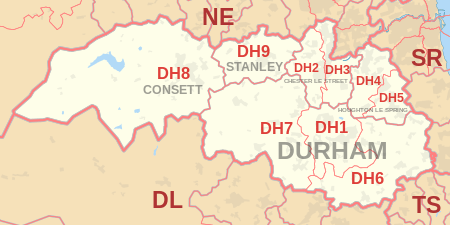
| Postcode district | Post town | Coverage | Local authority area |
|---|---|---|---|
| DH1 | DURHAM | Durham | County Durham |
| DH2 | CHESTER LE STREET | Chester-Le-Street (west of East Coast Main Line), Ouston, Pelton, Birtley (west of East Coast Main Line) | County Durham, Gateshead |
| DH3 | CHESTER LE STREET | Chester-le-Street (east of East Coast Main Line), Great Lumley, Birtley (east of East Coast Main Line) | County Durham, Gateshead |
| DH4 | HOUGHTON LE SPRING | Houghton le Spring (West of A690), Penshaw, Shiney Row | Sunderland |
| DH5 | HOUGHTON LE SPRING | Houghton le Spring (East of A690), Hetton-le-Hole | Sunderland |
| DH6 | DURHAM | South Hetton, Haswell, Shotton Colliery, Ludworth, Shadforth, Sherburn, Littletown, Kelloe, Coxhoe , Bowburn, Cassop, Pittington, Thornley, Wheatly Hill | County Durham |
| DH7 | DURHAM | Brandon, Lanchester, Esh Winning, Burnhope, Langley Park, Sacriston, Ushaw Moor, Brancepeth | County Durham |
| DH8 | CONSETT, DURHAM, STANLEY[3] | Consett, Blackhill, Bridgehill, Shotley Bridge, Leadgate, Delves Lane | County Durham, Northumberland County Council |
| DH9 | STANLEY | Dipton, Stanley, Annfield Plain | County Durham |
| DH97 | DURHAM | HM Passport Office[3] | non-geographic |
| DH98 | DURHAM | BT[3] | non-geographic |
| DH99 | DURHAM | National Savings and Investments[3] | non-geographic |
Map
See also
References
- ↑ "ONS Postcode Directory Version Notes" (ZIP). National Statistics Postcode Products. Office for National Statistics. February 2012. Table 2. Retrieved 21 April 2012. Coordinates from mean of unit postcode points, "Code-Point Open". OS OpenData. Ordnance Survey. February 2012. Retrieved 21 April 2012.
- ↑ Royal Mail, Address Management Guide, (2004)
- 1 2 3 4 "Non Geographic Codes" (PDF). Royal Mail Address Management Unit. July 2012. Archived from the original (PDF) on September 16, 2012. Retrieved 7 October 2012.
External links
This article is issued from Wikipedia - version of the 9/9/2016. The text is available under the Creative Commons Attribution/Share Alike but additional terms may apply for the media files.