DG postcode area
Postcode district boundaries: Bing / Google
| Dumfries postcode area | |
|---|---|
 DG | |
| Postcode area | DG |
| Postcode area name | Dumfries |
| Post towns | 14 |
| Postcode districts | 15 |
| Postcode sectors | 41 |
| Postcodes (live) | 6,784 |
| Postcodes (total) | 7,563 |
| Statistics as at February 2012[1] | |
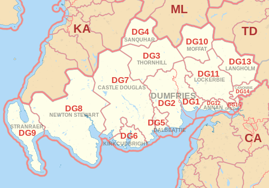
The DG postcode area, also known as the Dumfries and Galloway postcode area,[2] is a group of fifteen postcode districts in Scotland, which are subdivisions of fourteen post towns. These postcode districts cover most of Dumfries and Galloway, including Dumfries, Annan, Canonbie, Castle Douglas, Dalbeattie, Gretna, Kirkcudbright, Langholm, Lockerbie, Moffat, Newton Stewart, Sanquhar, Stranraer and Thornhill. The DG16 district also extends across the border into Cumbria, England.
Coverage
The approximate coverage of the postcode districts:
| Postcode district | Post town | Coverage | Local authority area |
|---|---|---|---|
| DG1 | DUMFRIES | Dumfries and Galloway | |
| DG2 | DUMFRIES | New Abbey | Dumfries and Galloway |
| DG3 | THORNHILL | Wanlockhead | Dumfries and Galloway |
| DG4 | SANQUHAR | Kirkconnel | Dumfries and Galloway |
| DG5 | DALBEATTIE | Dumfries and Galloway | |
| DG6 | KIRKCUDBRIGHT | Twynholm, Gatehouse of Fleet | Dumfries and Galloway |
| DG7 | CASTLE DOUGLAS | Dumfries and Galloway | |
| DG8 | NEWTON STEWART | Wigtown, Port William, Glenluce | Dumfries and Galloway, South Ayrshire |
| DG9 | STRANRAER | Castle Kennedy, Portpatrick, Sandhead | Dumfries and Galloway |
| DG10 | MOFFAT | Dumfries and Galloway | |
| DG11 | LOCKERBIE | Ecclefechan and Kirkpatrick Fleming | Dumfries and Galloway |
| DG12 | ANNAN | Dumfries and Galloway | |
| DG13 | LANGHOLM | Dumfries and Galloway | |
| DG14 | CANONBIE | Dumfries and Galloway | |
| DG16 | GRETNA | Dumfries and Galloway, Carlisle |
Map
See also
References
- ↑ "ONS Postcode Directory Version Notes" (ZIP). National Statistics Postcode Products. Office for National Statistics. February 2012. Table 2. Retrieved 21 April 2012. Coordinates from mean of unit postcode points, "Code-Point Open". OS OpenData. Ordnance Survey. February 2012. Retrieved 21 April 2012.
- ↑ Royal Mail, Address Management Guide, (2004)
External links
This article is issued from Wikipedia - version of the 8/24/2016. The text is available under the Creative Commons Attribution/Share Alike but additional terms may apply for the media files.