HA postcode area
Postcode district boundaries: Bing / Google
| Harrow postcode area | |
|---|---|
 HA | |
| Postcode area | HA |
| Postcode area name | Harrow |
| Post towns | 7 |
| Postcode districts | 10 |
| Postcode sectors | 58 |
| Postcodes (live) | 10,490 |
| Postcodes (total) | 16,747 |
| Statistics as at February 2012[1] | |
The HA postcode area, also known as the Harrow postcode area,[2] is a group of ten postcode districts in England which are subdivisions of seven post towns. These postcode districts cover part of the north-west of Greater London, as well as a very small part of south Hertfordshire.
The main sorting office is in Greenford (Green Park Way) and the area served includes virtually all of the London Borough of Harrow, the northeastern part of the London Borough of Hillingdon, the western part of the London Borough of Brent and a small part of the London Borough of Barnet, while the northern part of HA6 covers a small part of the Three Rivers district of Hertfordshire.
Coverage
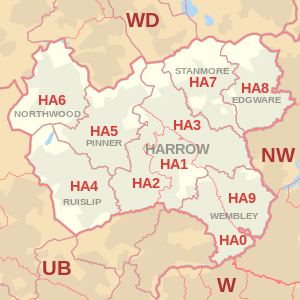
The approximate coverage of the postcode districts:
| Postcode district | Post town | Coverage | Local authority area |
|---|---|---|---|
| HA0 | WEMBLEY | Alperton, Sudbury, Sudbury Hill, Wembley Central and North Wembley | Brent, Harrow, Ealing |
| HA1 | HARROW | Harrow, Harrow on the Hill, North Harrow, Northwick Park, Sudbury, Sudbury Hill | Harrow, Brent |
| HA2 | HARROW | North Harrow, South Harrow, West Harrow, Rayners Lane (part) | Harrow |
| HA3 | HARROW | Harrow Weald, Kenton, Wealdstone, Queensbury, Belmont (part) | Harrow, Brent |
| HA4 | RUISLIP | Ruislip, Eastcote (part), South Ruislip, Ruislip Manor, Ruislip Gardens | Hillingdon |
| HA5 | PINNER | Pinner, Eastcote (part), Hatch End, Rayners Lane (part), Carpenders Park (part) | Harrow, Hillingdon, Three Rivers |
| HA6 | NORTHWOOD | Northwood, Northwood Hills, Moor Park | Hillingdon, Three Rivers |
| HA7 | STANMORE | Stanmore, Queensbury, Belmont (part) | Harrow, Brent |
| HA8 | EDGWARE | Edgware, Burnt Oak, Canons Park, Queensbury | Barnet, Brent, Harrow |
| HA9 | WEMBLEY | Wembley, Wembley Park, Wembley Central (East), Preston, Tokyngton | Brent |
Map
See also
References
- ↑ "ONS Postcode Directory Version Notes" (ZIP). National Statistics Postcode Products. Office for National Statistics. February 2012. Table 2. Retrieved 21 April 2012. Coordinates from mean of unit postcode points, "Code-Point Open". OS OpenData. Ordnance Survey. February 2012. Retrieved 21 April 2012.
- ↑ Royal Mail, Address Management Guide, (2004)