Berkhamsted
| Berkhamsted | |
| — Town — | |
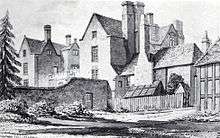
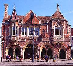 Berkhamsted Old Town Hall |
|
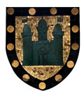 Coat of Arms |
|
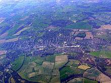
 Berkhamsted |
|
| Population | 18,100 (2013 est.)[1] |
|---|---|
| OS grid reference | SP993077 |
| District | Dacorum |
| Shire county | Hertfordshire |
| Region | East |
| Country | England |
| Sovereign state | United Kingdom |
| Post town | BERKHAMSTED |
| Postcode district | HP4 |
| Dialling code | 01442 |
| Police | Hertfordshire |
| Fire | Hertfordshire |
| Ambulance | East of England |
| EU Parliament | East of England |
| UK Parliament | South West Hertfordshire |
|
|
Coordinates: 51°46′N 0°34′W / 51.76°N 0.56°W
Berkhamsted /ˈbɜːrkəmstɛd/ is a medium-sized historic market town on the western edge of Hertfordshire, England. The affluent commuter town is located in the small Bulbourne valley in the Chiltern Hills, 26 miles (42 km) northwest of London.[2][3] Berkhamsted is a civil parish, with a town council within the larger borough of Dacorum.[4]
People have been living in the Berkhamsted area for over 5,000 years. There is evidence of flint working in the Neolithic period and metal working in the late Iron Age and Roman periods. The high street is on a pre-Roman route known by its Saxon name Akeman Street. The earliest written reference to Berkhamsted is in 970AD. Berkhamsted was recorded as a 'burbium' (an ancient borough) in the Domesday Book in 1086. The oldest known extant jettied timber-framed building in Great Britain, built 1277 - 1297, survives as a shop on the town's high street.[5][6] In the 13th and 14th century the town was a wool trading town, with thriving local market.
The most important event in the town's history was in December 1066. After William the Conqueror defeated King Harold's Anglo-Saxon army at the Battle of Hastings, the Anglo-Saxon leadership surrendered to the Norman encampment at Berkhamsted. The event was recorded in the Anglo-Saxon Chronicle. From 1066 to 1495, Berkhamsted Castle was a favoured residence held by many English royals, including Henry II and Edward, the Black Prince; and historical figures such as Thomas Becket and Geoffrey Chaucer.[7] After the castle was abandoned in 1495 the town went into decline, losing its borough status in the second half of the 17th century. Modern Berkhamsted began to expand following the construction of the canal and the railway in the 19th century.
Among those born in Berkhamsted was Colonel Daniel Axtell, who was the captain of the Parliamentary Guard at the trial and execution of Charles I in 1649. The towns literary connections include the 17th century hymnist and poet, William Cowper, the 18th century writer Maria Edgeworth, and the 20th century novelist Graham Greene. The town is the location of Berkhamsted School, a co-educational boarding independent school, founded in 1541 by John Incent, Dean of St Paul's Cathedral; and Ashlyns School a state school whose history began as the Foundling Hospital established in London by Thomas Coram, in 1742. The town is home to the Rex Cinema (a highly regarded independent cinema) and the British Film Institute's BFI National Archive at King's Hill, one of the largest film and television archives in the world, which was endowed by J. Paul Getty, Jr.[8]
History
Origin of the town's name
The earliest recorded spelling of the town's name is the 10th century Anglo-Saxon Beorhðanstædæ. The first part originates from the Old Celtic word Bearroc, meaning "hilly place"; alternatively it may originate from the Old English words beorg, meaning "hill", or berc or beorc, meaning "birch". The latter part, "hamsted", derives from the Old English word for homestead, and thus the town can be understood as either the "homestead amongst the hills" or the "homestead among the birches".[9][10]
Local historian Percy Birtchnell identified over 50 different spellings and epithets for the town's name since the writing of the Domesday Book; the present spelling was adopted in 1937.[11][12] Other spellings included: "Berkstead", "Berkampsted", "Berkhampstead", "Muche Barkhamstede", "Berkhamsted Magna", "Great Berkhamsteed" and "Berkhamstead".[13][14] The town's local nickname is "Berko".[15]
Prehistoric and Roman
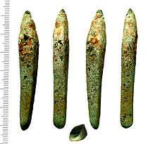
Neolithic, Bronze Age, Iron Age and Roman artefacts show that the Berkhamsted area of the Bulbourne Valley has been settled for over 5,000 years.[17][18][19] The discovery of a large number of worked flint chips provides Neolithic evidence of on-site flint knapping in the centre of Berkhamsted.[20] Several settlements dating from the Neolithic to the Iron Age (about 4500–100 BC) have been discovered south of Berkhamsted. Three sections of a late Bronze Age to Iron Age (1200–100 BC) bank and ditch, sixteen feet (five metres) wide by seven to thirteen feet (two to four metres) high and known as Grim's Ditch, are found on the south side of the Bulbourne Valley.[21][22] Another Iron Age dyke with the same name is on Berkhamsted Common, on the north side of the valley.[23][24]
In the late Iron Age, prior to the Roman occupation, the valley would have been within Catuvellauni territory.[21] The Bulbourne Valley was rich in timber and iron ore. In the late Iron Age, a four-square-mile (ten-square-kilometre) area around Northchurch became a major iron production centre, now considered to be one of the most important late Iron Age and Roman industrial areas in England.[25][23] Iron production led to the settlement of a Roman town at Cow Roast,[26] about two miles (three kilometres) northwest of Berkhamsted. Four first century iron smelting bloomeries at Dellfield (one mile (two kilometres) northwest of the town centre) provide evidence of industrial activity in Berkhamsted.[27][28] Production ceased at the end of the Roman period. Other evidence of Roman-British occupation and activity in the Berkhamsted area, includes a pottery kiln on Bridgewater Road.[29][24][30] The town's high street still follows the line of the Roman-engineered Akeman Street, which had been a pre-existing route from St Albans (Verulamium) to Cirencester (Corinium).
During Roman occupation the countryside close to Verulamium was subdivided into a series of farming estates.[31] The Berkhamsted area appears to have been divided into two or three farming estates, each including one or more masonry villa buildings, with tiled roofs and underfloor heating.
- The remains of a villa were found close to the river in 1973 in the adjacent village of Northchurch. The oldest building, made of timber, was built in AD 60, rebuilt using stone in the early 2nd century, and enlarged to a ten-room building around AD 150. The house may have been empty for a period, reoccupied in the 4th century, and abandoned in the late 4th or early 5th century.[32][33]
- A Roman-British villa, dyke, and temple were found 1.25 miles (2.01 km) NNW of the castle, near Frithesden, at the edge of the Berkhamsted Golf Course. Excavations in 1954 revealed masonry foundations and tesserae floors. Together, the villa, dyke and temple form a unique complex, suggesting occupation in the late Iron Age and Roman period.[34]
- Two flint and tile walls from a Roman building were found north of Berkhamsted Castle in 1970. The construction of the castle's earthworks in the Middle Ages may have damaged this building.[29][35]
Anglo-Saxon settlement
The earliest written reference to Berkhamsted is in the will of Ælfgifu (d. AD 970), queen consort of King Eadwig of England (r. 955–959), who bequeathed large estates in five counties, including Berkhamsted.[22][Notes 1] The location and extent of early Saxon settlement of Berkhamsted is not clear. Rare Anglo-Saxon pottery dating from the 7th century onwards has been found between Chesham Road and St John's Well Lane, with water mills near Mill Street in use from the late 9th century, show that an Anglo-Saxon settlement existed in the centre of modern-day Berkhamsted.[37] The nearest known structural evidence of the Anglo-Saxon period are in the south and west walls of St Mary's Northchurch, one mile (two kilometres) to the north west of modern Berkhamsted. The church may have been an important minster, attached to a high status Anglo-Saxon estate, which became part of the medieval manor of Berkhamsted after the Norman conquest.[22][38]
The parish of Berkhamsted St Mary's (in Northchurch) once stretched five miles from the hamlet of Dudswell, through Northchurch and Berkhamsted to the former hamlet of Bourne End. Within Berkhamsted, the Chapel of St James, was a small church situated near St John's Well (a 'holy well' that was the town's principal source of drinking water in the Middle Ages).[39] The parish of this church (and later that of St Peter's) was an enclave of about 4,000 acres (1,600 ha) that was carved out of the middle of Berkhamsted St Mary's.[Notes 2][40][13][41] By the 14th century the adjoining village of "Berkhamsted St Mary" or "Berkhamsted Minor" name had changed to "North Church", later "Northchurch", to distinguish the village from the town of Berkhamsted.[40][13][32][38][42]
1066 and the Domesday Record
The Anglo-Saxons surrendered the crown of England to William the Conqueror at Berkhamsted in early December 1066.[43][44] After William defeated and killed Harold II at the Battle of Hastings in October, he failed in an attempt to capture London from the south. William led his army around London, crossing the River Thames at Wallingford, "laying waste" while travelling through southeast England. At Berkhamsted, he received the surrender of Edgar the Ætheling (heir to the English throne), Archbishop Ealdred, Earl Edwin, Earl Morcar and the leaders of London.[44][45] It is not known why Berkhamsted was chosen as the meeting place, except Berkhamsted was in a defensive position north west of London. [Notes 3] William was crowned in Westminster Abbey on Christmas Day, 1066.[45] After his coronation, William granted the "Honour of Berkhamsted" to his half-brother, Robert, Count of Mortain,[47] who after William became the largest landholder in the country. Robert built a wooden fortification that later became a royal retreat for the monarchs of the Norman to Plantagenet dynasties.[48][49]
The lord of Berkhamsted prior to the Norman conquest was Edmer Ator (also referred to as Eadmer Atule), thegn of Edward the Confessor and King Harold.[Notes 4] The Domesday survey records that there was enough land for 26 plough teams, but only 15 working teams. There were two flour mills (Upper and Lower Mill), woodland for 1,000 pigs, and a vineyard.[51] The total population was calculated to be either 37 or 88 households; the families included 14 villagers, 15 smallholders, 6 slaves, a priest, a dyke builder (possibly working on the earthworks of the castle) and 52 burgesses.[52] Some historians have argued that the number 52 burgesses in Berkhamsted was a clerical error, as it is a high number for a small town.[53][54] Berkhamsted was described in the Domesday Book as a burbium (ancient borough) in the Tring Hundred.[52][55]([Notes 5]) Marjorie Chibnall argued that Robert, Count of Mortain intended Berkhamsted to be both a commercial and defensive centre;[57] while John Hatcher and Edward Miller believed that the 52 burgesses were involved in trade, but it is unknown if the burgesses existed prior to the conquest.[58]
Royal medieval castle (11th to 15th centuries)
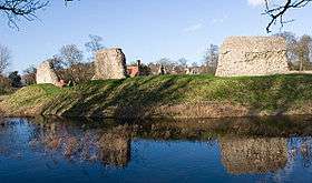
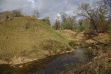
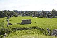
Berkhamsted Castle is a well-documented example of an 11th-century motte-and-bailey Norman castle, with historical records dating from the 12th to 15th centuries.[59] The castle was a high-status residence and an administrative centre for large estates.[60] The royal castle's presence clearly affected the town. It created jobs for the local population, both in the castle itself and also, for example, in the large deer park[61][62][63] and in the vineyard, which were maintained alongside the castle.[60] Moreover, for nearly 400 years, patronage from the royal court connected to the castle helped fuel the town's growth, prosperity and sense of importance.[64]
Robert, Count of Mortain's heir William rebelled against and lost the castle to Henry I. In 1155–65, Henry II's favourite, Thomas Becket, was given Berkhamsted. Becket was later alleged to have spent over £300 on improvements to the castle, a claim that led Henry to accuse him of corruption and may have contributed to Becket's downfall.[65] Henry II extensively used the castle, making it one of his favourite residences. Both King Richard I and King John gave the castle to their queens, Berengaria of Navarre and Isabella of Angoulême, respectively. In King John's reign, Geoffrey Fitz Peter (c. 1162–1213),[Notes 6] Earl of Essex and the Chief Justiciar of England (effectively the king's principal minister) held the Honour and Manor of Berkhamsted from 1199 to 1212. During his time in the castle he was responsible for the foundation of the new parish church of St Peter (the size of which reflects the growing prosperity of the town), two hospitals, St John the Baptist and St John the Evangelist (one of which was a leper hospital), which survived until 1516, and the lay out of the town.[66][67][68] In December 1216, the castle was besieged during the civil war, known as the First Barons' War, between King John and barons supported by Prince Louis (the future Louis VIII of France), who captured the castle on 20 December 1216 after twenty days using siege engines and counterweight trebuchets.[49][69][70]
In 1227, Henry III's younger brother, Richard, 1st Earl of Cornwall, was given the manor and castle, beginning the long association of the castle with the Earls and later the Dukes of Cornwall.[71][72] [Notes 7] Richard redeveloped the castle as a palatial residence and the centre for the administration of the Earldom of Cornwall. Richard's coat of arms as Earl of Cornwall, along with bezants, is included in Berkhamsted's coat of arms. Henry III's wife, Sanchia of Provence, died in the castle in 1260. Richard was succeeded by his son, Edmund, 2nd Earl of Cornwall, who founded Ashridge Priory, a college of the monastic order of Bonhommes, in 1283. In 1300, after Edmund died, Edward I - aka 'Longshanks' took the castle and subsequently granted it to his second queen, Margaret of France. In 1309, Edward I and Margaret's son, Edward II, granted Berkhamsted to his favourite, Piers Gaveston; afterwards In 1317, the castle was given to Edward II's queen, Isabella of France.[49][70]
Edward III further developed the castle and gave it to his son, Edward, the Black Prince, who expanded the hunting grounds. By tradition, Berkhamsted Castle still belongs to the eldest son of the reigning English monarch, via the Duchy of Cornwall.[73] The castle was used to hold royal prisoners, including John II of France. In 1361, the "Hero of Berkhamsted", Edward, the Black Prince, and Joan, the Maid of Kent, spent their honeymoon in Berkhamsted. The Black Prince was supported at the Battle of Crecy by local bowmen - Everard Halsey, John Wood, Stephen of Champneys, Robert Whittingham, Edward le Bourne, Richard of Gaddesden and Henry of Berkhamsted (who was rewarded with 2d a day and appointed porter of Berkhamsted Castle after he saved the prince's baggage at the Battle of Poitiers). Richard II inherited Berkhamsted Castle in 1377 and gave it to his favourites, Robert de Vere and John Holland. In 1400, Henry IV lived in the castle after he deposed Richard, and he used the castle to imprison others attempting to obtain the throne. During this time, Geoffrey Chaucer, later famous for writing The Canterbury Tales, oversaw renovation work on the castle in his role as Clerk of the Works at Berkhamsted Castle and other royal properties. It is unknown how much time he spent at Berkhamsted, but he knew John of Gaddesden, who lived in nearby Little Gaddesden and who was the model for the Doctor of Phisick in The Canterbury Tales. Henry V and Henry VI owned the castle, the latter making use of it until he was overthrown in 1461. In 1469, Edward IV gave the castle to his mother, Cecily Neville, Duchess of York, who was the last person to live in the castle.[49][70]
In 1833, the castle was the first building to receive statutory protection in the United Kingdom. In 1834, construction of the railway embankment demolished the castle's gatehouse and adjacent earthworks.[74] Since the 1930s, the castle ruins have been managed by English Heritage, under the guardianship of the Secretary of State for National Heritage, and are freely open to the public.[49][70]
Medieval market town (12th to 15th centuries)
Though close to the castle, the town continued to develop on the old Akeman Street .4 miles (1 km) to the south of the castle and to the west of St Peter's Church; with a triangle formed by Mill Street, Castle Street and Back Lane pointing towards the castle.[75][76] In 1156, Henry II officially recognised Berkhamsted as a town in a royal charter, which confirmed the laws and customs enjoyed under Edward the Confessor, William I and Henry I, and freed the town's merchants from all tolls and dues. The charter also stated that no market could be set up within 7 miles (11 km) of the town.[62]
The town became a trading centre on an important trade route in the 12th and 13th centuries, and Berkhamsted received more royal charters. In 1216, Henry III relieved the men and merchants of the town from all tolls and taxes everywhere in England, and the English Plantagenet possessions in France, Normandy, Aquitaine and Anjou[77] The growing wool trade brought prosperity to Berkhamsted from the 12th century until the early Tudor period.[78][79] Four wealthy Berkhamsted wool merchants were amongst a group in Bruges to whom Edward III wrote in 1332,[79][58] and Berkhamsted merchants sold cloth to the royal court.[58]
Henry III in 1217 recognised by royal charter the town's oldest institution, Berkhamsted's pre-existing market.[77][80][Notes 8] Trades within medieval Berkhamsted were extensive: early in the 13th century the town had a merchant, two painters, a goldsmith, a forester, two farriers, two tailors, a brewer of mead, a blacksmith, carpenters, wood turners, tool makers, a manufacturer of roofing tiles and wine producers.[81][13] In the mid–13th century, a banker, the wealthy Abraham of Berkhamsted, financier to the Earl of Cornwall, lived in the town; this was unusual for a small town in a time of heightened persecution of Jews.[82] In 1290, a taxation list mentions a brewer, a lead burner, a carpenter, leather workers, a fuller, a turner, a butcher, a fishmonger, a barber, an archer, a tailor, a cloth-napper, a miller, a cook, a seller of salt and a huntsman.[81] At this time, larger houses of merchants and castle officials appeared on the south side of the high street (including 173 High Street, the oldest known extant jettied building in England). In 1307 Berkhamsted was a large town with an estimated population of 2,000 to 2,500.[83] In 1355, there were five butchers, two bakers, nine brewers, two cobblers, a pelter, a tanner, five cloth dyers, six wheelwrights, three smiths, six grain merchants, a skinner and a baker/butcher.[81] In the 14th century, Berkhamsted (recorded as "Berchamstede") was considered to be one of the "best" market towns in the country.[84] In a survey of 1357, Richard Clay was found to own a butcher's shop twelve feet (four metres) wide, William Herewood had two shops, and there were four other shops eight feet (two metres) in length. In 1440, there is a reference to lime kilns.[13]
The town benefited when Edmund, 2nd Earl of Cornwall founded Ashridge Priory in 1283, two miles (three kilometres) from the town and within the castle's park. At the foundation of the abbey, the Earl donated a phial claimed to contain Christ's blood. Pilgrims from all over Europe passed through the town to see the holy relic. The abbey grew quite wealthy as a result.[85] Edward I held parliament at the abbey in 1290 while he spent Christmas in Pitstone.[85] Berkhamsted burgesses sent two members to parliament in 1320, 1338 and 1341, but the town was not represented again.[53] In the mid-14th century, the Black Prince took advantage of the Black Death to extend the castle's park by 65 acres (26 ha), eventually producing a park covering 991 acres (401 ha).[86] In the 15th century, the town is reaffirmed as a borough, by a royal charter granted by Edward IV (1442–1483), that decreed that no other market town was to be set up within 11 miles (18 km).
Castle abandoned, the town in decline (16th to late 18th century)
In the 16th century, the town fell into decline after abandonment of the castle following the death of Cicely Neville, Duchess of York in 1495, and the rise of the nearby town of Hemel Hempstead (which was granted a Charter of Incorporation by Henry VIII on 29 December 1539). Berkhamsted Castle passed through the hands of three of Henry VIII's wives: Catherine of Aragon, Anne Boleyn and Jane Seymour. After the Dissolution of the Monasteries, Henry VIII bequeathed Ashridge Priory to his daughter Elizabeth.[87] The priory became her private residence during her sister Mary I's reign.[88] The population of the town in 1563 has been estimated at only 545.[89] In 1580, the castle ruins and the park were leased by Elizabeth I to Sir Edward Carey, for the nominal rent of one red rose each year.[90][91] Stone from the castle was used to build Berkhamsted Place, a local school, and other buildings in the late 16th century.[92][93] Brewing and maltings was noted as one of the town’s principal industries in the reign of Elizabeth.[94] Around 1583, a new market house was erected west of St Peter's Church at the end of Middle Row (alternatively named Le Shopperowe or Graball Row). The market house was destroyed in a fire in 1854.
In 1612, Berkhamsted Place was bought by Henry Frederick, Prince of Wales for £4,000. Henry, who died later that year, bequeathed the house to his brother Charles (later King Charles I),[95] who leased the property to his tutor, Thomas Murray, and his wife, Mary Murray, who had been his nurse and Lady of the Privy Chamber to the prince's mother. John Norden wrote in 1616 that the making of malt was then the principal trade of the town.[13] In 1618, James I reaffirmed Berkhamsted's borough status with a charter. Following surveys in 1607 and 1612 the Duchy of Cornwall enclosed 300 acres (121 ha) from the Common (now known as Coldharbour farm) despite local opposition led by Rev Thomas Newman. In 1639 the Duchy again tried to enclose a further 400 acres (162 ha) of the Berkhamsted and Northchurch Commons but were prevented from doing so by William Edlyn of Norcott. The castle's park, which had reached 1,252 acres (507 ha) in size by 1627, was broken up over the next two decades, shrinking to only 376 acres (152 ha), to the benefit of local farmers.[96][97] In 1643, Berkhamsted was visited by a violent pestilential fever.[13]
Born in Berkhamsted, Colonel Daniel Axtell(1622 – 19 October 1660), a Baptist and a grocer's apprentice, played a zealous and prominent part in the English Civil War, both in England and in the Cromwellian conquest of Ireland. He participated as a lieutenant colonel in Pride's Purge of the Long Parliament (December 1648), arguably the only military coup d'état in English history, and commanded the Parliamentary Guard at the trial of King Charles I at Westminster Hall in 1649. During Cromwell's Protectorate, he appropriated Berkhamsted Place. Shortly after the Restoration, the unrepentant Axtell was hanged, drawn and quartered as a regicide.[98] After the Restoration of the monarchy under Charles II, the town lost its charter given by James I and its borough status. The surveyor of Hertfordshire recommended that a new tenant and army officers were needed at Berkhamsted Place "to govern the people much seduced of late by new doctrine preacht unto them by Axtell and his colleagues."[99] The estimated population of the town in 1640 and in the 1690s was 1075 and 767, respectively.[89] The town was a centre of religious nonconformity from the 17th century: over a quarter of the town were Dissenters in the second half of the century,[100] and in 1700, there were 400 Baptists recorded as living in Berkhamsted.[101] Three more shops are mentioned in the row next to the church, and the Parliamentary Survey of 1653 suggests that the area near the Market House was used for butchery.[102]
Development of the modern town (19th and 20th century)
- 19th century urban growth
In the 17th and 18th-centuries Hemel Hempstead with its thriving market, eclipsed Berkhamsted as the major town in the area.[64] Georgian Berkhamsted barely extended beyond the medieval triangle and the High Street. With the coming of the Industrial Age, Berkhamsted was well placed at a gateway through the Chilterns, between the markets of London and the industrial Midlands. The town became a link in the growing network of roads, canals and railways. These developments led Berkhamsted's population to once again expand. In 1801, the population of St Peter's parish had been 1,690 and in 1831, this had risen to 2,369 (484 houses). An 1835 description of the town found that "the houses are mostly of brick, and irregularly built, but are interspersed with a fair proportion of handsome residences".[103] The town's population increased as "hundreds of men arrived to build the railway line and needed lodging";[104] by 1851, the population was 3,395,[105] From 1850 large estates around Berkhamsted were sold, allowing for housing expansion. In 1851 the Pilkington Manor estate, east of Castle Street, was sold, and the land developed both as an industrial area and for artisans’ dwellings. In 1868 streets of middle-class villas began to appear on the hill south of the High Street [104] [106] Lower Kings Road was built by public subscription in 1885 to join Kings Road and the High Street to the station.[8] In 1887, John Bartholomew's Gazetteer of the British Isles recorded the population at 4,485.[107][104]
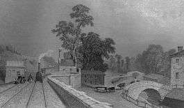
- 19th century industry and utilities
.jpg)
Industries in the 19th century included:
- · Timber: In the mid-18th century, Berkhamsted had been noted for turned wood products. Based on the extensive woodland resources of the area (principally alder and beech), the milling and turning of wood was the town's most prominent industry in the 19th century. The Crimean War contracts for supplying the army with lance poles and tent pegs led to major expansion.[108] The largest manufacturer was East & Sons.
- · Brush making: An offshoot of the timber industry. The largest employers were Goss Brushworks at the west end of the High Street (closed 1930s) and T.H. Nash in George Street (closed 1920s).[108]
- · The Canal Trade provided a considerable economic stimulus to the town, enabling the development of industries which involved bulk transport of materials. These included timber and malt.[108]
- · Boat building: Berkhamsted also became a centre for the construction of the barges needed for the canal trades.[109] A yard for building canal barges and other boats between Castle Street and Raven's Lane wharves, was one of three important boatyards in Hertfordshire. It was owned by John Hatton until 1880 and then by William Costin until 1910 when it was taken over by Key's, the timber merchants which in 1969 was bought by another timber merchant J. Alsford before being redeveloped into flats in 1994. Located at this site, adjacent to the canal is the Berkhamsted Canadian totem pole.
- · Watercress: The construction of the canal had helped to drain the marshy areas along the valley of the River Bulbourne. In 1883, the Berkhamsted Times congratulated Mr Bedford on having converted the remaining "dirty ditches and offensive marshes" into watercress beds.[110]
- · Chemical: Cooper's sheep-dip works; William Cooper was an animal doctor who arrived in Berkhamsted in the early 1840s and experimented in treatments for scab in sheep. He formulated an innovative arsenic and sulphur sheep-dip.[108] The Cooper family firm was later inherited by his nephew, Sir Richard Cooper, 1st Baronet.
- · Nurserymen: Henry Lane's nurseryman business, founded in 1777, became one of the largest employers in the town in the 19th century. Extensive nurseries are shown on the 1878 OS 25 inch plan, at the western end of the town.
- · Iron working: Wood's Ironworks was set up in 1826 by James Wood.[110]
Utilities in the 19th century included:
- · Gasworks: The Great Berkhamsted Gas, Light & Coke Co., at the junction of Water Lane and the Wilderness, was set up to provide street lighting in 1849. In 1906, the Berkhamsted Gas Works moved to Billet Lane; it closed in 1959.[94]
- · Water and sewage: The Great Berkhamsted Waterworks Company was set up in 1864 on the high street (on the present site of W.H. Smith and Boots). Mains drainage was first supplied in 1898–99, when effective sewerage was installed.[94]
- Provision for the destitute

In 1725 "An Account of Several Workhouses", records a parish workhouse in Berkhamsted and a parliamentary report of 1777 refers to a parish workhouse for up to 34 inmates in Northchurch. A small "wretched, straw-thatched" house was used to house poor families in Berkhamsted, on the corner of what is now Park View Road, until it was demolished in the 1820s. In 1831 a bequest of £1,000 by the Revd George Nugent, led to a new parish workhouse being set up on the site of a workhouse, which had operated in a row of tenements on the High Street (at the Kitsbury Road junction) known as Ragged Row.[111] The "Berkhampstead Poor Law Union" was formed in June 1835 covering ten parishes centring on the town. The Union took over the existing Berkhamsted parish workhouse and by August 1835 it became the sole workhouse for the union. The workhouse had no schoolroom, so in 1849, the Poor Law Board recommended that pauper children be sent to the local National School, although in 1858 the school complained about the state of children attending from the workhouse. A fever ward was erected in 1855, and a full-time nurse was engaged in 1868. The workhouse system officially came to an end in 1930, and control over the workhouse was given to local council. Nugent House, The Berkhamsted workhouse, finally closed in 1935 and its function was relocated to Hemel Hemspstead.[111][112] In 1841, the Countess of Bridgewater built a soup kitchen for the local poor within the ruins of Berkhamsted Castle. The soup kitchen was used by an estimated 15% of the population of Berkhamsted (about 500 people) during the winter months, until at least 1897. The building still stands connected to the cottage in the castle grounds, why it was placed outside the town and inside the ruins of the historic castle is unknown.[113]

- Land dispute The Battle of Berkhamsted Common
In 1761, the wider estate and the castle were separated, the former being leased to the Duke of Bridgewater, while the latter remained in the direct control of the Duchy of Cornwall. In 1863, the estate and park were sold off to Earl Brownlow, who agreed to rent the castle from the duchy for a nominal rent.[115][116] In 1866, Lord Brownlow of Ashridge House tried to enclose Berkhamsted Common with 5-foot (2 m) steel fences (built by Woods of Berkhamsted) in an attempt to claim it as part of his estate. In order to defend historic rights of the public at large to use ancient common land Augustus Smith MP and George Shaw-Lefevre organised local folk and 120 hired men from London's East End to dismantle the fences and protect Berkhamsted Common for the people of Berkhamsted on the night of the 6 March, in what became known nationally as the Battle of Berkhamsted Common.[117][118] Brownlow brought a legal case against Smith for trespass and criminal damage, Sir Robert Hunter (later co-founder of the National Trust in 1895) and the Commons Preservation Society defended the action. Lord Justice Romilly determined that pulling down a fence was no more violent an act than erecting one. The case, he said, rested on the legality of Brownlow’s actions in having erected the fence in the first place and the legal right of people to use the land. He ruled in favour of Smith, a legal decision, along with the Metropolitan Commons Act 1866, that helped ensure the protection of Berkhamsted Common and other open spaces nationally threatened with enclosure. In 1926 the common was acquired by the National Trust.[119][120][121]
- First World War
During the First World War, under the guidance of Lt Col Francis Errington, the Inns of Court Officer Training Corps trained men from the legal profession as officers. Over the course of the war, 12,000 men travelled from Berkhamsted to fight on the Western Front. Their training included trench digging: eight miles (thirteen kilometres) of trenches were dug across the Common (of which 1,640 feet (500 m) remain). The Inns of Court War Memorial on the Common has the motto Salus Populi Suprema Lex – the welfare of the people is the highest law – and states that the ashes of Colonel Errington were buried nearby.[122][123][124]
- 20th Century
In 1909 Sunnyside and later in 1935 Northchurch were added to Berkhamsted Urban District. Shortly after 1918 much of the extensive estate belonging to Berkhamsted Hall, at the east end of the High Street, was sold; many acres west of Swing Gate Lane were developed with Council housing. More council housing was built at Gossoms End. Development on the north side of the valley was limited until the sale of the Ashridge estate in the 1930s after which housing appeared at each end of Bridgewater Road.[125] Meanwhile, over the last century, many of the old industrial firms in Berkhamsted closed, while the numbers of commuters increased.
After the Second World War, in July 1946, the nearby town of Hemel Hempstead was designated a New Town under the New Towns Act ("New Towns" were satellite urban developments around London to relieve London's population growth and housing issues after the blitz). February 1947 the Government purchased 5,910 acres (2,392 ha) of land and began construction, which led Hemel Hempstead's population to increased from 20,000 to today over 90,000, making it today the largest town in Hertfordshire.[126] In 1974, the old hundred of Dacorum became the modern district of Dacorum formed under the Local Government Act 1972, based in Hemel Hempstead.
Geography
Berkhamsted is situated 26 miles (42 km) northwest of London within the Chiltern Hills, part of a system of chalk downlands throughout eastern and southern England, believed to have formed between 84 and 100 million years ago in the Cretaceous Period when the area was a chalk-depositing marine environment.[127] The town is located in a narrow northwest to southeast valley falling from 590 feet (180 m) above sea level to 344 feet (105 m). The valley is at the southernmost limit of the Pleistocene glaciation ice erosion throughout the Chiltern scarp, giving it a smooth rounded appearance, with alluvial soils in the valley bottom and chalk, clay and flint on the valley sides.[25][128] The River Bulbourne, a chalk stream, runs through the valley for seven miles (11 km) in a southeast direction, starting at Dudswell and the adjoining village of Northchurch and running through Berkhamsted, Bourne End and Boxmoor, where it merges with the River Gade at Two Waters in Apsley, near Hemel Hempstead.
In the early Mesolithic period (Middle Stone Age, mid to late 8th millennium BC), the local upland was mostly pine woodland and the low area of central Berkhamsted probably a grass-sedge fen. In the 6th Millennium BC the dense deciduous forest became well established. By the Mid to late 3rd millennium BC during the Neolithic period (the New Stone Age) human activity can be seen in wood clearances; the woodland being then dominated by lime trees, with alder trees growing on the flood plain. The River Bulbourne, rich in eels and other fish, was fast-moving and full, and prone to frequent localised flooding.[17] The river created a marsh environment (at times referred to as an 'unhealthy swamp') in the center of the valley.[129][75] The river powered the watermills (recorded in 1086) and fed the three moats of the large Norman Motte and Bailey castle, that stands close to the center of the town where a small dry combe joins the Bulbourne valley.
The layout of Berkhamsted's centre is typical of a medieval market settlement; the linear High Street (aligned on the Roman Akeman Street) forms the spine of the town(roughly aligned east-west), from which extend medieval burgage plots (to the north and south). The surviving burgage plot layout is the result of a comprehensive plan carried out in the beginning of the 13th century, most probably instigated by Geoffrey fitz Peter.[79][55] The town centre slowly developed over the years and contains a wide variety of properties that date from the 13th century onwards. The modern town began to develop after the construction of the Grand Junction Canal in 1798. The canal intersects the river at numerous points, taking most of its water supply and helping to drain the valley. The locality became further urbanised when the London to Birmingham railway was built in 1836–37.[25][130][131] The townscape was shaped by the Bulbourne valley, which rises 300 feet on either side at its narrowest point; the residential area is elongated and follows the valley's topography.[132][133] The southwest side of the valley is more developed, with side streets running up the steep hillside; on the northeast side, the ground gently slopes down to the castle, railway, canal and small river, was less available for development. Today, Berkhamsted is an affluent,[134] "pleasant town tucked in a wooded fold in the Chiltern Hills";[135] with a large section of the settlement protected as a conservation area.[132][136]

The countryside surrounding the town includes parts of the Green Belt and the Chilterns Area of Outstanding Natural Beauty. The Urban Nature Conservation Study (UNCS) recognises the town's hinterland as a biodiversity resource. The hills gently rise to an undulating and open plateau, which has a mix of arable farmland, common land and mixed oak, ash and beech woodland. On the northeast side of town are the Berkhamsted and Northchurch commons, the largest in the Chilterns at 1,055 acres (427 ha), and forming a large arc running from Northchurch, through Frithsden and down to Potten End. Ownership of Berkhamsted Common is divided between the National Trust and Berkhamsted Golf Club. Beyond the common is the 5,000-acre (2,000 ha) historic wooded parkland of Ashridge; once part of Berkhamsted Castle's hunting park, it is now managed by the National Trust. Ashridge is part of the Chilterns Beechwood Special Area of Conservation (SAC), a nationally important nature conservation area, and is also designated as a Site of Special Scientific Interest. Agriculture is more dominant to the south of the town; close to the Buckinghamshire border there are two former large country estates, Ashlyns and Rossway. The ancient woodland at Dickshills is also located here.[132][137][138]
Neighbouring settlements
 |
Tring | Little Gaddesden | Great Gaddesden | |
| Wendover | |
Hemel Hempstead | ||
| ||||
| | ||||
| Great Missenden | Chesham | Bovingdon |
- Local villages
Bourne End, Nettleden, Frithsden Potten End, Aldbury, Ringshall, Little Gaddesden, Great Gaddesden, Northchurch, Cow Roast, and Ashley Green (Buckinghamshire)
Climate
Like most of the United Kingdom, Berkhamsted has an oceanic climate (Köppen climate classification Cfb).
| Climate data for Berkhamsted | |||||||||||||
|---|---|---|---|---|---|---|---|---|---|---|---|---|---|
| Month | Jan | Feb | Mar | Apr | May | Jun | Jul | Aug | Sep | Oct | Nov | Dec | Year |
| Average high °C (°F) | 6 (43) |
7 (45) |
10 (50) |
12 (54) |
16 (61) |
19 (66) |
21 (70) |
22 (72) |
18 (64) |
14 (57) |
9 (48) |
6 (43) |
13 (55) |
| Average low °C (°F) | 3 (37) |
3 (37) |
4 (39) |
5 (41) |
8 (46) |
10 (50) |
12 (54) |
13 (55) |
11 (52) |
8 (46) |
5 (41) |
3 (37) |
7 (45) |
| Average precipitation mm (inches) | 69.3 (2.728) |
59.4 (2.339) |
46.5 (1.831) |
70.1 (2.76) |
58.1 (2.287) |
58.9 (2.319) |
46.0 (1.811) |
68.9 (2.713) |
51.7 (2.035) |
84.3 (3.319) |
93.9 (3.697) |
80.9 (3.185) |
788.0 (31.024) |
| Source: [139] | |||||||||||||
Near-real-time weather information can be retrieved from Berkhamsted Weather Station on the Met Office Weather Observation Website, with station status information at Berkhamsted Weather Station
Governance

Recognised as a borough as far back as the Domesday Book — today Berkhamsted has a town council, the first tier of local government that represents the local people to two higher tiers of local government, Dacorum Borough Council and Hertfordshire Country Council. The local government district of Dacorum also includes the towns of Hemel Hempstead (the largest town in Hertfordshire), Tring and the western part of Kings Langley. The modern district of Dacorum based in Hemel Hempstead was formed in 1974 under the Local Government Act 1972; Berkhamsted accounted for just over 14% of the district's population of 145,300 in 2011.[140] Berkhamsted is split into three local government Wards — East, West and Castle. Following the 2015 town council elections the political composition of the council was Conservative 12; Liberal Democrat 3.[141]
Until the 1997 general election, Berkhamsted was, with Hemel Hempstead, part of the former West Hertfordshire parliamentary constituency. The town is now in the South West Hertfordshire constituency represented in the House of Commons since 2005 by David Gauke, a Conservative. At the General Election 2015 he had a majority of over 23,000.[142] The constituency seat forms a thin strip along the southwest border of Hertfordshire, from South Oxhey (near Watford) in the south, through interspersed settlements including Chipperfield, Chorleywood, Croxley Green, Moor Park and Rickmansworth to Tring in the north.[143]
Demography
Homes
The Hertfordshire Local Information System (HertsLIS) website (based on data from the Office for National Statistics and other UK government departments) has the following data regarding the 7,363 households in Berkhamsted in 2011. Regarding housing tenure, 72 percent of homes were owner occupied (34 percent owned outright and 38 percent owned with a mortgage), 13 percent were social rented, and 13 percent were private rented. In 2011, 77 percent of household spaces in Berkhamsted were houses or bungalows and 23 percent were flats or maisonettes. In third quarter of 2015 average houses and flats prices in Berkhamsted were £640,800, compared to £407,300 for Hertforshire, and £286,700 for England (detached houses were £1,057,600 compared to £389,200 nationally).[144]
Employment
In mid-2013, the Office for National Statistics estimated the working age population (males and females aged 16 to 64) of Berkhamsted as 11,400, (63% of the total population). According to HertsLIS in 2011, 76 percent of Berkhamsted residents between the ages of 16 and 74 were employed (including: full-time, 43 percent; part-time, 13 percent; self-employed, 14 percent) and 24 percent were economically inactive (including: retired, 13 percent; long term sick/disabled, 2 percent).[145] In April 2013, the benefit unemployed rate in Berkhamsted's parliamentary constituency was 1.7 percent, compared to 7.8 percent for the UK.[146] People from Berkhamsted were employed as follows: 17.5 percent worked as managers, directors and senior officials; 27.5 percent professional occupations and 8.5 percent in associate professional and technical occupations; 10 percent were employed in administrative and secretarial occupations; 7 percent in skilled trades; 6 percent Caring, leisure and other service occupations; 5 percent were in sales and customer service occupations; 3 percent were in process, plant and machine operatives; and 5.5 percent worked in elementary occupations.[145] Of the employed residents living in both Berkhamsted and Tring, 35 percent live and work in the towns, whilst 65 percent commute to workplaces out of the towns, particularly to London.[147] Of the 7,100 people who work in Berkhamsted, 58 percent commute to Berkhamsted to work. In 2011, 9.5 percent of Berkhamsted residents (aged 16 to 74 in employment) worked mainly at or from home; 52 percent drove to work by car (2.5 as a passenger in a car); 22.34% travelled by public transport and 12.73% cycled or walked to work. In 2011, during an average commute to work, was 21 kilometres.[145]
Diversity
Looking at broad ethnic heritage in 2011, HertsLIS data found that 90 percent of residents were described as white British. Of the remainder, 1 percent were Irish, 4 percent were of other white origin, 1.7 percent were described as mixed or multiple ethnic, 2.1 percent were Asian or Asian British, 0.3 percent were black African/Caribbean or black British and 0.3 percent were Arab or any other ethnic group. Regarding religious beliefs in 2011, of the 92 percent of residents who stated a religious preference, 30 percent were non-religious and 59 percent were Christian; other faiths included 0.4 percent Buddhist, 0.5 percent Jewish, 0.5 percent Muslim and 0.1 percent Sikh.[145]
Relationships and education
In 2011 the marital and civil partnership status of residents aged 16 and over were as follows 28 percent single, 56 percent married, 0.1 percent in a registered same-sex civil partnership, 2 percent separated, 8 percent divorced or legally dissolved same-sex civil partnership and 6 percent widowed or surviving partner from a same-sex civil partnership. Looking at the qualifications table, 12 percent of residents had no qualifications, 10 percent reached level 1, 13 percent achieved level 2, 2 percent had apprenticeship qualifications, 10 percent were level 3 and 49 percent achieved level 4 or above.[145]
Transport

Road
The former Roman-engineered Akeman Street through the town became, in 1762, part of the Sparrows Herne turnpike, notorious for its rutted and pitted state even after becoming a toll road. Many coaching inns thrived along its route, including, in Berkhamsted, the King's Arms (where the exiled King Louis XVIII of France carried on a romance with Polly Page, the innkeeper's daughter).[148][149] The town's historic high street is now the A4251. A bypass, originally proposed in the 1930s, was opened in 1993, and the main A41 road now passes southwest of Berkhamsted. A study of car ownership in Berkhamsted, Northchurch and Tring found that 43%–45% of households had two or more cars (compared to the county average of 40% and the national average of 29%). Conversely, the proportion of households who did not own a car was 14%–20% (about 7% lower than the national average).[150] A number of local bus routes pass through Berkhamsted town centre, providing links to Hemel Hempstead, Luton, Watford and Whipsnade Zoo. Services include the 30, 31, 62, 207, 500 (Aylesbury and Watford), 501, 502 and 532. Buses are managed by Hertfordshire County Council's Intalink transport service.[151][152]
Canal
In 1798, the Grand Junction Canal (built by William Jessop) from the River Thames at Brentford to Berkhamsted was completed; it was extended to Birmingham in 1805.[154] Castle Wharf (The Port of Berkhamsted), on the south side of the canal between Ravens Lane and Castle Street, was the centre of the town's canal trade, navigation and boat building activities. It was a hub of the country's inland water transport system, linking the ports and industrial centres of the country. Main activities included the transport of coal, grain, building materials and manure. Timber yards, boating wharves, breweries, boat building and chemical works flourished as a result of the canal, with over 700 workers employed locally. It is still known as the "Port of Berkhamsted". Separately, Francis Egerton, 3rd Duke of Bridgewater (the "Canal Duke" and "father of the inland waterway system"), lived in Ashridge, near Berkhamsted. The canal became part of the Grand Union Canal in 1929. Once an important trade artery, today the Grand Union Canal, Canal Fields and river provide an open space, recreational opportunities, and a wildlife corridor running east–west through the centre of the town.

Railway
The next stage in the town's transport history occurred in 1834 when, after opposition from turnpike trusts and local landowners was resolved, the first Berkhamsted railway station was built by chief engineer Robert Stephenson. Though the castle was the first building to receive statutory protection from Parliament, the railway embankment obliterated the old castle barbican and adjacent earthworks. Most of the raw materials used to build the railway were transported via the canal.[155] The present station was built in 1875 when the railway was widened. It is unusual on its line, in that most of the original buildings have been retained. The 'large trunk station' is located immediately next to Berkhamsted Castle on one side and overlooks the Grand Junction Canal on the other. The station is 28 miles (45 km) north west of London Euston on the West Coast Main Line.[156]' One and a half million journeys are made annually to and from Berkhamsted, the vast majority by commuters to and from London.[157] Principal services, operated by London Midland, run between London Euston and Milton Keynes Central, with additional trains running to Northampton and Birmingham New Street. The Southern train company also runs an hourly service directly to South Croydon via Clapham Junction. Proposals to extend the new Crossrail service out of London through Berkhamsted to Milton Keynes Central were considered by the Department for Transport in 2014,[158][159] but in 2016 it was announced that the scheme had been cancelled due to "poor overall value for money to the taxpayer".[160]
Economy and commerce
In 1986, farming, service and light industry were characteristic local occupations.[161] In 2015 schools and retail (predominantly Waitrose) constitute the town's largest employers; these are both situated in Berkhamsted Castle ward.[150] The Berkhamsted West ward (especially around Billet Lane, close to the canal and railway) is where most of the town's small to medium-sized industrial firms are located. The British Film Institute (BFI) is an important local employer to the south of Berkhamsted.
In November 2014, the Academy of Urbanism's Urbanism Awards found Berkhamsted's High Street to be a "vibrant" and "bustling" road, that "worked extremely well as a quality high street."[162] They considered the layout for the street to be exemplary for its time (it was put in place following the construction of a bypass in the early 1990s), creating a "pleasant" and "successful" shopping environment and allowing people to take advantage of a good "range of specialist shops and numerous cafes, restaurants and pubs", together with the "strong supermarket" offering set in "well-crafted re-configured streetscape". The long high street featured one hundred percent retail occupancy, independent traders and a "cafe culture".[163] The Academy considered a particularly strong aspect of the street to be the good working collaboration between individual businesses and the Chamber of Trade. Berkhamsted has an active Transition Town community.[135]
Education
State schools
In the 1970s, the town adopted a three-tier state school education system, reverting to the two-tier system of primary and secondary schools in 2013. The primary stage is provided by Bridgewater, Greenway, St Thomas More, Swing Gate, Thomas Coram, Victoria (founded in 1838) and Westfield.
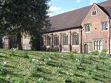
Ashlyns School is a Foundation school with 1,200 pupils aged 11 to 19 years; it is a specialist language college. The school's history began in the 18th century when Thomas Coram, a philanthropic ship's captain, was appalled by the abandoned babies and children starving and dying in London. He campaigned for a hospital to accommodate them and was successfully granted a Royal Charter "for the Maintenance and Education of Exposed and Deserted Children" in 1739. Three years later in 1742 he established the Foundling Hospital at Lamb’s Conduit Fields in Bloomsbury, London. It was the first children's charity in the country and the precedent for incorporated associational charities everywhere.[164] The school moved to its purpose built location in Berkhamsted in 1935. The residential home side at Berkhamsted closed following the Children Act 1948, when family centered care replaced institutional care. In 1951 Hertfordshire County Council took over running the school.[165][166][167] The large school contains stained glass windows, especially around the chapel, a staircase and many monuments from the original London hospital. The school's chapel formerly housed an organ donated by George Frideric Handel.[165] The school was used a backdrop to the 2007 comedy film, Son of Rambow.
Independent schools
Berkhamsted School is an independent public school formed by the joining of two schools in 1988 – Berkhamsted School, founded in 1541 by Dean John Incent, Dean of St Paul's Cathedral (and financed from the combined revenues of the town's two medieval hospitals, St John the Baptist and St John the Evangelist which had survived until 1516) and Berkhamsted School for Girls, which had been founded in 1888.[168][66][67] The school has 1,500 fee paying pupils, aged 3 to 18. Among the school's former students was the author Graham Greene.[169] The Old Building was built in 1544 and is Grade I listed.
Egerton Rothesay School, an independent school founded in 1922, has 150 pupils between the ages of 5 and 19.[170]
Religious sites
The oldest extant church locally is St Mary's in the adjacent village of Northchurch. Between 1087 and 1104, there is reference to a chaplain called Godfrey and to a chapel of St James with parochial status within St Mary's Berkhamsted's parish. The chapel situated close to St Johns, located close to St John's Lane, was the base for a small community of monks, the Brotherhood of St John the Baptist, in the 11th and 12th centuries.[171][172][Notes 9]
During King John's reign, Geoffrey Fitz Peter, was instrumental in the foundation the parish church of St Peter, and in 1222, Robert de Tuardo, was registered as the first known rector.[173] Because of the church's proximity to Berkhamsted Castle, the reigning monarch was patron of Berkhamsted rectors for several centuries. In 1648, St Peter's Church was requisitioned during the English Civil War by General Fairfax as a military prison to hold soldiers captured from the Siege of Colchester.[174] The poet William Cowper was christened in St Peter's,[100] where his father John Cowper was Rector.[175]
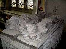
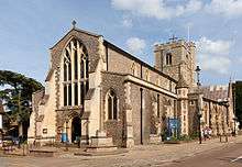
The parish church of St Peter, is one of the largest churches in Hertfordshire, stands on the high street.[176] The church is in the Latin cross plan, with a 85-foot (26 m) clock tower at the crossing and measures 56 yards (51 m) from the west door to the east window, and the width across the transepts is 30 yards (27 m). The oldest part of the church is the chancel, which is dated at c. 1200; it is in the Early English style common in that period.[177] Further additions were made up until the 15th century; in 1871, it underwent a restoration by William Butterfield. There are two altar tombs with alabaster effigies dating from the 14th century: the tombs are of a knight (thought to be Henry of Berkhamsted, one of the Black Prince's lieutenants at the Battle of Crecy) and his lady. There are two other Anglican churches in the town – 'St Michael and All Angels' (Sunnyside)(original building 1886) and 'All Saints' Church & St Martha's' (built in 1906, to cater for the growing population in the west end of the town).
The town has a strong Non-conformist tradition, in 1672 a survey found that there were 400 Anglian conformists and 150 Non-conformists in Berkhamsted, when such beliefs could bring you foul of the law. The Baptist community in Berkhamsted, dates from 1640 making it one of the oldest nationally; first gathering in secret, they built a large chapel in 1722, and moved to their current place of worship at the junction of Ravens Lane on the High Street in 1864.[100] A Quaker community is present in the town from the second half of the 17th century, they opened their Meeting House in 1818 on the High Street opposite St John's Well Lane.[178] The Congregationlists can be traced back to 1780, they now worship combined with the Presbyterian church at St Andrew's United Reformed Church on the corner of Castle Street and Chapel Street.[178] The Methodists arrived with the hundreds of men who came to build the railway, via various places of worship, today they share All Saints' Church with the Anglians.[179] The Evangelist (Latter Day Saints) began life has part of the Plymouth Bretheren, their Hope Hall opened in 1875, which was rechristened the Kings Road Evangelical Church in 1969.[180] The Roman Catholic tradition from the 17th to 20th century appears to be limited, General de Gaulle worshiped at their original Church of the Sacred Heart in Park View Road, they moved to a larger modern church in 1980 on Park Street.[181]
Culture and leisure
Literary connections
Geoffrey Chaucer was clerk of works at Berkhamsted Castle from 1389 and based his Doctor of Phisick in The Canterbury Tales on John of Gaddesden, who lived in nearby Little Gaddesden. William Cowper was born in Berkhamsted Rectory in 1731. Although he moved away when still a boy, there are frequent references to the town in his poems and letters. In the Victorian era, Cowper became a cult figure and Berkhamsted was a place of pilgrimage for his devotees. Maria Edgeworth, a prolific Anglo-Irish writer of adults' and children's literature who was a significant figure in the evolution of the novel in Europe, lived in Berkhamsted as a child in the 18th century.[24] Between 1904 and 1907, the Llewelyn Davies boys were the inspiration for the author and playwright J. M. Barrie's Peter Pan.[182] A little later, novelist Graham Greene was born in Berkhamsted and educated at Berkhamsted School, alongside literary contemporaries Claud Cockburn, Peter Quennell, Humphrey Trevelyan and Cecil Parrott.[183] Children's authors H. E. Todd and Hilda van Stockum both lived in Berkhamsted. The comic character Ed Reardon from Radio 4's semi-naturalistic radio drama Ed Reardon's Week resides in Berkhamsted.
Cinema
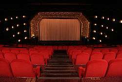
The Rex Cinema is regarded by some, including the Daily Telegraph, as Britain's most beautiful cinema.[184] Described by Dame Judi Dench as "absolutely awe-inspiring", in 2014, the Rex was declared Britain's Best Cinema in the inaugural Guardian film awards.[185][186] Built in 1937 the Rex is recognised by English Heritage as a fine example of a 1930s art deco cinema. The cinema was designed by architect David Evelyn Nye for the Shipman and King circuit.[187] Closed in 1988, the cinema was extensively restored in 2004 and has become a thriving independent local cinema.[188] The Rex frequently has sold-out houses for evening showings, the cinema is a "movie palace with all the original art deco trimmings" (its interior features decorations of sea waves and shells). Inside is a step "back into the golden age of film" when going to the movies was an experience; the cinema features luxurious seating and two licensed bars. It is managed by its owner James Hannaway, who introduces films. Sometimes there is a question and answer session with directors and actors involved in the films; these sessions have included Dame Judi Dench, Charles Dance, Mike Leigh and Terry Jones.[189]
Prior to the cinema's construction, an Elizabethan mansion, Egerton House, had occupied the site at the east end of the high street for 350 years. The house was occupied briefly (1904–07) by Arthur and Sylvia Llewelyn Davies, whose children were J. M. Barrie's inspiration for Peter Pan.[182]
British Film Institute National Archive at King's Hill
Rarely open to the public, the BFI National Archive's "The J. Paul Getty, Jr. Conservation Centre" in Berkhamsted is the archive of the British Film Institute.[190] With over 275,000 feature, non-fiction and short films (dating from 1894) and 210,000 television programmes, it is one of the largest film archives in the world. Two of the archive's collections were added to the United Nations Educational, Scientific and Cultural Organisation (UNESCO) UK Memory of the World Register, in 2011.[191] The archive collects, preserves, restores and shares the films and television programmes which have shaped and recorded British life and times since the development of motion picture film in the late 19th century. The majority of the collection is British-originated material, but the archive also features internationally significant holdings from around the world and films that feature key British actors and the work of British directors.
Sport
The Berkhamsted Bowmen are the oldest archery club in England.[183] There is a sports centre off Douglas Gardens, managed by the Dacorum Sports Trust (Sportspace). The facilities comprise a large indoor multi-purpose sports hall, squash courts, swimming pool and outdoor all-weather pitch. This facility is complemented by dual use of the leisure facilities of Ashlyns School and Berkhamsted Collegiate School. A deficit in leisure space is compounded by a high level of sports participation locally and consequent heavy use of outdoor sports pitches. Founded in 1875 Berkhamsted Cricket Club competes in the Herts League and in 2015 it ran twenty-five separate teams. The nine Berkhamsted and Hemel Hempstead Hockey Club teams are based just outside the town at the Cow Roast, playing their matches at Tring School. There are two Bowls clubs, Berkhamsted and Kitcheners.[192] Berkhamsted and the surrounding area has a variety of road cycling and mountain biking routes, including traffic-free off-road routes in Ashridge Estate.[193] The town was visited by the Tour of Britain in 2014.[194]
The town's football club, Berkhamsted F.C., play in the Spartan South Midlands League Premier Division. The team was formed in 2009 after the demise of Berkhamsted Town F.C., which had been established in 1895. They play at the town's football ground, Broadwater, which they share with Watford L.F.C., who play in the FA Women's Super League Division 2. Founded in 1996, Berkhamsted Raiders C.F.C. football club was recognised as the FA Charter Standard Community Club of the Year at the English Football Association Community Awards in 2014 and awarded the UEFA Grassroots Silver Award in 2015 for their work across the local community. The club in 2015 had more than 800 affiliated players, including 90 girls and 691 boys in the youth set-up, 29 ladies, 20 seniors and 20 veterans: who are spread across 65 teams at different levels.[195][196] The club is based at the Berkhamsted Community Cricket and Sports Club, Kitcheners Field, Castle Hill, Berkhamsted.
Sites of interest

The majority of Berkhamsted's eighty-five listed or scheduled historical sites are on in the high street and the medieval core of the town (a significant number of them contain timber frames). Four are scheduled, one is Grade I, seven are Grade II*, the remaining 75 are Grade II.[197][198] In addition to the sites noted in the article above (such as the castle and schools) the following structures and locations are of interest:
- 173 High Street is a Victorian façade hiding what is considered to be the oldest extant jettied timber-framed building in Great Britain, dated by dendrochronology of structural timbers to between 1277 and 1297.[5][6][199] The building was originally thought to be been a jeweller or goldsmith's shop with a workshop behind, it is now believed to have been a jettied service wing to a larger aisled hall house, which has since disappeared.[22] It represents an early example of transition in carpentry technology, from the use of passing braces to crown posts. The 13th century origin of the structure was discovered by chance in 2000 by builders who had begun work on what appeared to be a Victorian property. The shop was, from 1869, Figg's the Chemists; post-restoration (with expertise and a £250,000 grant from English Heritage), the shop is currently used as an estate agency. Dr Simon Thurley, Chief Executive of English Heritage, said "This is an amazing discovery. It gives an extraordinary insight into how Berkhamsted High Street would have looked in medieval times."[200]
- 125 High Street, a house and shop opposite St Peter's Church, is a timber-framed building with a wing that is one bay of a 14th-century open hall. The layout suggests that it once had a second bay of similar size – a length of 26 feet (8 m) in all. This was an unusually large house; its size and central position suggests a manor house or other high status house, possibly supporting the castle. The building underwent extensive alterations in the 17th, 18th and 19th centuries.[201]
- The Swan, 139 High Street, contains the remains of a medieval open hall. Parts of the roof date from the 14th century, and the street range was extended and a chimney stack added c. 1500.[22]
- Castle Street began life as the medieval lane from the town's high street to the drawbridge of the royal castle. The other end of the lane was the parish church of St Peters. In the 16th century next to the church, Berkhamsted school was founded, while in the 17th century there were seven public houses amongst the street's trade outlets.[202]
- To the northwest of Berkhamsted stand the ruins of Marlin's Chapel, a 13th-century chapel standing next to a medieval fortified farm. The walls and moat surrounding the modern farm still remain and are reputed to be haunted.[117]
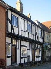
- 129 High Street is the Grade II* listed house known as Dean Incent's House. (John Incent, Dean of St Paul's, founded Berkhamsted School.) A 15th century half-timbered house, the interior has original exposed timber framing and several Tudor wall paintings. The building incorporates part of an even older structure and was used as public meeting place before the Court House was built. The house is not normally open to the public.[149][203]
- The Court House, next to the church, dates from the 16th century, and is believed to lie on the site of the medieval court where the Portmote [Notes 10] or Borough Court was held.[22]
- Sayer's Almshouses, were the legacy of John Sayer, chief cook to Charles II, at 235–241 High Street, comprise a single-storey row of almshouses built in 1684.[207]
- The Bourne School, at 222 High Street, was the legacy by Thomas Bourne (1656–1729) (Master of the Company of Framework Knitters) to build a charity school in Berkhamsted for 20 boys and 10 girls. The front was rebuilt in 1854 in Jacobean-style red brick; it is not clear if any part of the building predates 1854. In 1875, the pupils were transferred to the National School and the funds used for scholarships.[208]
- The site now occupied by the Pennyfarthing Hotel dates from the 16th century, having been a monastic building used as accommodation for religious guests passing through Berkhamsted or going to the monastery at Ashridge.
- The town hall, a Victorian gothic market house and town hall, designed by architect Edward Buckton Lamb (built in 1859, extended in 1890, restored in 1983–1999), was built by public subscription from Berkhamstedians.[209] It comprised a market hall (now Carluccio's restaurant), a large assembly hall and rooms for the Mechanics' Institute. When Berkhamsted became part of the new Dacorum Borough Council (based in Hemel Hempstead), there were plans to demolish the building, these plans werer stopped by a ten-year citizens' campaign during the 1970s and 1980s, which eventually ended at the High Court.[209]
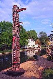
- The Berkhamsted Canadian totem pole sits adjacent to the canal, close to Castle Street Bridge. In the early 1960s, Roger Alsford, a great-grandson of the founder of the timber company, James Alsford (1841–1912), went to work at the Tahsis lumber mill on Vancouver Island. During a strike, he was rescued from starvation by a local Kwakiutl community. Alsford's brother, William John Alsford, visited the island, and in gratitude for the local people's hospitality, commissioned a totem pole from the Canadian First Nations artist Henry Hunt.[210] The western red cedar pole, 30 feet (9 m) high and 3 feet (1 m) in diameter, was carved by Hunt at Thunderbird Park, a centre for First Nation monuments. The completed pole was shipped to Britain and erected at Alsford's Wharf in 1968. Alsford's warehouses were replaced in 1994 by a private housing development which limit access to the pole, so that it can be viewed only at a distance from the public road. It is one of only a handful of totem poles in the United Kingdom, others being on display at the British Museum and Horniman Museum in London, Windsor Great Park, Bushy Park and the Yorkshire Sculpture Park.[211] The carvings on the totem pole represent four figures from First Nations legend: at the top sits Raven, the trickster and creator deity; he sits on the head of Sunman, who has outstretched arms representing the rays of the sun and wears a copper (a type of ceremonial shield); Sunman stands on the fearsome witch-spirit Dzunukwa; at the base is the two-headed warrior sea serpent, Sisiutl, who has up-stretched wings.[212]
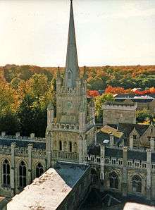 Spire of chapel, Ashridge House, showing Ashridge Forest behind
 - Ashridge, an estate managed by the National Trust of 5,000 acres (2,000 ha) of native broadleaf woodlands, commons and chalk downland on a Chiltern ridge just to the north of Berkhamsted.[213] Ashridge has been featured many times in film and television series due to its distinction as an area of natural beauty. Scenes were filmed for Sleepy Hollow at Golden Valley and Harry Potter and the Goblet of Fire at Ashridge's ancient Frithsden Beeches Wood.[214]
- Ashridge House (built within Berkhamsted Castle's former park) is a Grade I listed building, constructed between 1808 and 1814 to a design by James Wyatt with later work by his nephew Jeffrey Wyattville. It is the former seat of the Bridgewaters and later the Brownlow family. Architecture critic Nikolaus Pevsner described it as the "largest of the romantic palaces near London ... a spectacular composition". The house occupies the site of the earlier Ashridge Priory, a college of the monastic order of Bonhommes founded in 1283 by Edmund, 2nd Earl of Cornwall, who resided in the castle. After the Dissolution of the Monasteries, Henry VIII bequeathed the property to his daughter, Elizabeth. In 1800, it was the home of Francis Egerton, 3rd Duke of Bridgewater, affectionately known as the Father of Inland Navigation.[215] His climbable monument (a Grade II* listed building) is a tall Doric column with urn that stands in a grove within Ashridge.
Associations with the town
Twin towns
Berkhamsted is twinned with:
-
 Beaune, Burgundy, France[216]
 -
 Neu Isenburg, Hesse, Germany (as part of Dacorum)
The town also has an informal relationship with Barkhamsted, Connecticut, in the United States. The latter presented a gavel and block on 4 July 1976, the U.S. bicentennial, which Berkhamsted Town Council now uses in meetings.
Footnotes
- ↑ Æthelgifu's will is one of only seventeen existing wills in Old English, and it is the most extensive of them. It gives much more detail on slave and land ownership in this period than any other document, and shows that a woman could have considerable wealth. The will is written on vellum in a minuscule hand, and the original still exists; an American consortium bought it in 1969, and it is now in New Jersey.[36]
- ↑ This left a detached portion of the St Mary's parish, which later became the village of Bourne End, southeast of the Berkhamsted.
- ↑ Historians in the past, have believed the town was of Mercian importance or in the existence of a pre–Norman conquest fortification (there is reference to land called "Oldeburgh"). The Anglo-Saxon word burgh hints at a pre-conquest fortification. The notable early 20th century historian G. M. Trevelyan, including earlier historians such as Samuel Lewis and Sir Henry Chauncy, believed that the town was once an important Mercian settlement.[46] Two medieval ditches have been excavated in recent years, both of which were discovered on Bridgewater Road, north of the river, that may have been part of a ditch that surrounded the early medieval town.[22]
- ↑ Edmer Ator was evidently a senior landholding noble who had held 36 places over 7 counties prior to the Norman conquest, as recorded in the Domesday Book.[50]
- ↑ Later in the Middle Ages the Tring Hundred merged with the Danais Hundred, "which overlapped it", to form the Dacorum Hundred. Danais referred to Danish settlers in the area. A monk writing about this area described it as "the Hundred of the Danes", using the word Daneis. The word was later incorrectly transcribed as "Danicorum" and subsequently shortened to "Dacorum".[56]
- ↑ The patronymic is sometimes rendered "Fitz Piers", since he was the son of Piers de Lutegareshale, forester of Ludgershal.
- ↑ One of the wealthiest men in Europe, Richard, 1st Earl of Cornwall, was elected King of Germany, or Holy Roman Emperor, in 1256.
- ↑ The market had been in existence since at least 1086. It was originally held on a Sunday, but by this charter it was changed to Monday, as the rector of the new St Peter's Church objected to the noise. The market is now held on a Saturday.
- ↑ For many centuries, the Berkhamsted town fair was held on the feast day of St James the Greater rather than on Petertide, which suggests that an older parish church before St Peter's was built in the 13th century.[42]
- ↑ Also referred to as portmanmoot or portmoot. The name had Anglo-Saxon origins; the court had aspects both of court and of council meeting.[204][205][206]
References
- ↑ "Community Profiles - Summary Profile Selection: Berkhamsted Geo-type: Large Settlements A to B". The Hertfordshire Local Information System (HertsLIS). Community Information and Intelligence Unit, Hertfordshire County Council. Retrieved 8 April 2015.
- ↑ "Berkhamsted Conservation Area Character Appraisal & Management Proposals" (PDF). Dacorum Borough Council. 2012. Retrieved 5 February 2015.
- ↑ "The Changing Landscape of the Chilterns" (PDF). Chilterns Historic Landscape Characterisation Project. Chilterns Conservation Board and Buckinghamshire County Council. 2009. Retrieved 20 January 2015.
- ↑ Hastie 1999, p. 73.
- 1 2 Historic England. "173 High Street, Berkhamsted (1246942)". National Heritage List for England. Retrieved 8 April 2015.
- 1 2 "Restoration boost for oldest shop". BBC News. 26 February 2003. Retrieved 17 September 2014.
- ↑ "Berkhamsted Castle". Chilterns Conservation Board. Retrieved 17 February 2015.
- 1 2 Hastie 1999, p. 60.
- ↑ Mills, David (2011). A Dictionary of British Place-Names. Oxford University Press. p. 53. ISBN 978-019960908-6.
- ↑ Caroline Taggart (2011). The Book of English Place Names: How Our Towns and Villages Got Their Names. Random House. p. 153. ISBN 978009194043-0.
- ↑ Langston, Brett. "Berkhampstead Registration District". GENUKI. Retrieved 31 March 2015.
- ↑ Langston, Brett. "Berkhamsted Registration District". GENUKI. Retrieved 31 March 2015.
- 1 2 3 4 5 6 7 Page 1908, pp. 162–179
- ↑ Cobb 1883.
- ↑ Herman, Judi (1 April 2010). "Joseph Millson talks about loving life in Berko". BBC. Retrieved 13 November 2014.
- ↑ Bolton,A. "Finds record for: WAW-C4A5F5". The Portable Antiquities Scheme. Retrieved 23 Oct 2015.
- 1 2 Hastie 1999, p. 7.
- ↑ Thompson & Bryant 2005, pp. 2-5.
- ↑ "Berkhamsted Official Guide 2004" (PDF). Retrieved 3 October 2014.
- ↑ "Berkhamsted Police Station Berkhamsted Hertfordshire Archaeological Evaluation" (PDF). Cotswold Archaeology. January 2015. Retrieved 4 April 2015.
- 1 2 Dyer, James (2001). Discovering Prehistoric England (2nd ed.). Princes Risborough, UK: Shire. pp. 19–20. ISBN 978-074780507-6.
- 1 2 3 4 5 6 7 Semmelmann, Karin (July 2004). "343–351 High Street, Berkhamsted Herts. Desk-Based Archaeological Assessment" (PDF). Heritage Network. Retrieved 17 September 2014.
- 1 2 Thompson & Bryant 2005, p. 3.
- 1 2 3 "Archaeological Desk-Based Assessment of Land at Gossoms End, Berkhamsted, Hertfordshire" (PDF). Report 2013-1334. nps archaeology. Retrieved 10 December 2014.
- 1 2 3 "Area 117 Upper Bulbourne Valley" (PDF). Landscape Character Assessment for Dacorum. Dacorum Borough Council. 2004. pp. 93–96.
- ↑ "Cow Roast Pottery". Dacorum Heritage Trust. Retrieved 1 October 2014.
- ↑ "The National Slag Collection: A simple catalogue" (PDF). Retrieved 23 December 2014.
- ↑ McDonnel. "Ancient Monuments Laboratory Report 3971" (PDF). A survey of the iron working industry in England 700BC to 1600AD. Retrieved 24 December 2014.
- 1 2 Thompson & Bryant 2005, p. 4.
- ↑ "Archaeological Desk-Based Assessment : Castle Wharf, Bridge Street Berkhamsted Hertfordshire" (PDF). Retrieved 20 September 2014.
- ↑ Hastie 1996, p. 14.
- 1 2 "St Mary's church – Our History". Retrieved 31 July 2011.
- ↑ "Northchurch Roman Villa". Dacorum Heritage Trust. Retrieved 20 September 2014.
- ↑ Historic England. "Berkhamsted Common Romano-British villa, dyke and temple (1020914)". National Heritage List for England. Retrieved 19 October 2014.
- ↑ Historic England. "Site of Roman building, N of Berkhamsted Castle (1005253)". National Heritage List for England. Retrieved 20 September 2014.
- ↑ Whitelock 1968, p. 14.
- ↑ Thompson & Bryant 2005, pp. 5-6.
- 1 2 Williamson 2010, p. 152.
- ↑ Hastie 1999, p. 16.
- 1 2 Thompson & Bryant 2005, p. 5.
- ↑ "4/01211/12/MFA – Redevelopment And Alterations To Provide Mixed Retail Development With Associated Car Parking, Servicing, Landscaping And Other Associated Works" (PDF). Retrieved 29 November 2014.
- 1 2 Page 1908, pp. 245-250.
- ↑ Remfry 1998, p. 9.
- 1 2 Presenter: Sam Willis, Director: Ben Southwell (4 December 2014). "1. Instruments of Invasion". Castles: Britain's Fortified History. 5.05 – 6.20 minutes in. BBC. BBC 4.
- 1 2 Mills, Peter (1996). "The Battle of London 1066" (PDF). London Archaeologist. 8 (3): 59–62.
- ↑ Carter, Laura. "'Essentially an historical play': Berkhamsted pageant play, 1922". Redress of the Past. Retrieved 13 November 2014.
- ↑ Page 1908, p. 165.
- ↑ "Berkhamsted Castle". Retrieved 22 October 2014.
- 1 2 3 4 5 "Time Line". Berkhamsted Local History & Museum Society. Retrieved 14 December 2014.
- ↑ "Name: Edmer Ator". Open Domesday. Retrieved 7 December 2014.
- ↑ Thompson & Bryant 2005, pp. 6, 12.
- 1 2 "Place: Berkhamsted". Open Domesday. Retrieved 21 November 2014.
- 1 2
 Chisholm, Hugh, ed. (1911). "Berkhampstead". Encyclopædia Britannica. 3 (11th ed.). Cambridge University Press. p. 782.
 - ↑ Slater & Goose 2008, pp. 226–227.
- 1 2 "Berkhamsted Conservation Area Character Appraisal & Management Proposals" (PDF). Retrieved 23 September 2014.
- ↑ "About Dacorum". Dacorum Heritage Trust. Retrieved 20 January 2015.
- ↑ Marjorie Chibnall (1991). Proceedings of the Battle Conference 1990. Boydell & Brewer Ltd. pp. 134–. ISBN 978-0-85115-286-8.
- 1 2 3 Hatcher, John; Miller, Edward (2014). Medieval England: Towns, Commerce and Crafts, 1086–1348. Routledge. p. 27. ISBN 978-131787287-0.
- ↑ Historic England. "Berkhamsted motte and bailey castle (1010756)". National Heritage List for England. Retrieved 20 September 2014.
- 1 2 Williamson 2010, p. 219.
- ↑ Rowe 2007, p. 132.
- 1 2 Thompson & Bryant 2005, p. 6.
- ↑ Liddiard 2005, pp. 111–112.
- 1 2 Hastie 1996, p. 202.
- ↑ Spigelman, James J. (2004). Becket & Henry: The Becket Lectures. Sydney, Australia: St Thomas More Society. p. 146. ISBN 978-064643477-3.
- 1 2 Mackenzie 1896, p. 128
- 1 2 Cobb 1883, pp. 14, 72.
- ↑ Hastie 1999, p. 17.
- ↑ "History of the Magna Carta 1216 Berkhamsted (siege)". 2014 Magna Carta 2015 Committee / HCL Technologies. Retrieved 8 October 2014.
- 1 2 3 4 Remfry 1998.
- ↑ Brown 1989, p. 52.
- ↑ Pettifer 1995, p. 105
- ↑ "Ancient Monuments". Duchy of Cornwall. Retrieved 21 November 2014.
- ↑ Richards, Jeffrey. "The role of the railways". In Wheeler, Michael. Ruskin and Environment: The Storm-cloud of the Nineteenth Century. Manchester: Manchester University Press. p. 125. ISBN 978-071904377-2.
- 1 2 Thompson & Bryant 2005, p. 10.
- ↑ "300 High Street, Berkhamsted, Hertfordshire" (PDF). Retrieved 20 November 2014.
- 1 2 "History of Berkhamsted by Percy Birchnell". Retrieved 1 October 2014.
- ↑ Slater & Goose 2008, pp. 240–241.
- 1 2 3 Thompson & Bryant 2005, p. 9.
- ↑ "Hertfordshire". Gazetteer of Markets and Fairs in England and Wales To 1516 Hertfordshire. British History Online. Retrieved 5 February 2015.
- 1 2 3 Slater & Goose 2008, p. 240.
- ↑ Caroline Hillaby, ed. (16 August 2013). The Palgrave Dictionary of Medieval Anglo-Jewish History. Palgrave Macmillan. ISBN 9781137308153. Retrieved 23 September 2014.
- ↑ Slater & Goose 2008, p. 56.
- ↑ "Berkhamsted Conservation Area Character Appraisal & Management Proposals" (PDF). Retrieved 24 December 2014.
- 1 2 "House of Bonhommes: The college of Ashridge', A History of the County of Buckingham: Volume 1 (1905), pp. 386–390". Retrieved 28 June 2010.
- ↑ Rowe 2007, pp. 131–144
- ↑ "History of Ashridge – Ashridge Business School". Retrieved 17 June 2014.
- ↑ "MSN Encarta". Archived from the original on 31 October 2009.
- 1 2 Slater & Goose 2008, Table 5.3.
- ↑ Thompson & Bryant 2005, p. 12.
- ↑ Mackenzie 1896, p. 130.
- ↑ Thompson & Bryant 2005, pp. 10, 13.
- ↑ Hands, Joan (10 November 2010). "The "extraordinary" market that put Hemel Hempstead on the map". Dacorum Heritage Trust. Retrieved 1 October 2014.
- 1 2 3 Thompson & Bryant 2005, p. 26.
- ↑ "Cunningham, David, −1659". Retrieved 20 October 2014.
- ↑ Cobb 1883, pp. 46–47.
- ↑ Sumner Chilton Powell (1 May 2011). Puritan Village: The Formation of a New England Town. Wesleyan University Press, 1 May 2011. p. 22. ISBN 9780819572684.
- ↑ "Axtell, Daniel (bap. 1622, d. 1660), parliamentarian army officer and regicide by Alan Thomson". Retrieved 22 September 2014.
- ↑ Henry Reece (2013). The Army in Cromwellian England 1649 – 1660'. Oxford University Press.
- 1 2 3 Hastie 1999, p. 102.
- ↑ Reid Doster, G. (1977). "Discipline and ordination at Berkhamsted General Baptist Church, 1712–1718" (PDF). Baptist Quarterly. 27 (3): 128–138.
- ↑ "HISTORIC BUILDING ASSESSMENT: SITE ADJACENT TO 3 & 4 CHURCH GATES, CHURCH LANE, BERKHAMSTED, HERTFORDSHIRE" (PDF). Archaeological Services & Consultancy Ltd. November 2004. p. 12. Retrieved 16 October 2015.
- ↑ Society for the Diffusion of Useful Knowledge (1835). "The Penny Cyclopaedia of the Society for the Diffusion of Useful Knowledge". Knight. Retrieved 10 December 2014.
- 1 2 3 Thompson & Bryant 2005, p. 23.
- ↑ "Market Towns Of Hertfordshire (from SDUK Penny Cyclopedia)". Retrieved 24 September 2014.
- ↑ Hastie 1999, p. 68.
- ↑ "Berkhamsted Hertfordshire". A Vision of Britain through Time. University of Portsmouth. Retrieved 17 March 2015.
- 1 2 3 4 Thompson & Bryant 2005, p. 24.
- ↑ Thompson & Bryant 2005, pp. 22,25.
- 1 2 Thompson & Bryant 2005, p. 25.
- 1 2 Thompson & Bryant 2005, p. 27.
- ↑ "The Workhouse - Berkhampstead/Berkhamsted, Hertfordshire". Retrieved 26 July 2015.
- ↑ Carstairs Phillip (11 Apr 2016). "Berkhamsted Castle and the Countess of Bridgewater's soup house: magic kingdoms and heterotopias in Hertfordshire". Retrieved 29 August 2016.
- ↑ Mabey, Richard (7 November 2015). "The queen beech ruled the land, even when she fell". New Statesman. Retrieved 7 November 2015.
- ↑ Cobb 1883, p. 26.
- ↑ Sherwood 2008, p. 245.
- 1 2 Birtchnell 1988.
- ↑ "Herts History: The Battle of Berkhamsted". Hertfordshire Life. 14 March 2016. Retrieved 27 March 2016.
- ↑ "Mr. Shaw-Lefevre on the Preservation of Commons". The Times. 11 December 1886. p. 10.
- ↑ Ashbrook, Kate. "Modern commons: a protected open space?" (PDF). Retrieved 24 October 2014.
- ↑ "Exhibition and commemorative walk marks anniversary of battle to save Berkhamsted Common". Hemel Gazette. Johnston Publishing Ltd. 12 October 2015. Retrieved 14 October 2015.
- ↑ "Berkhamsted, Hertfordshire: Where the Law was Trained for War". Retrieved 11 November 2014.
- ↑ "WWI commemorative edition" (PDF). Retrieved 29 November 2014.
- ↑ Cross, Michael (2 July 2014). "In search of the Inns of Court trenches". The Law Society Gazette. Law Society. Retrieved 1 March 2015.
- ↑ Thompson & Bryant 2005, p. 32.
- ↑ "War and boom prompted an exodus from city to town". The Dacorum Heritage Trust Ltd. 20 April 2011. Retrieved 25 July 2015.
- ↑ Catt, John. "Geology on your Doorstep". Hertfordshire Geological Society. Retrieved 28 December 2014.
- ↑ "Domesday Reloaded 1986: Farming in Berkhamsted". BBC. Retrieved 21 September 2014.
- ↑ Hastie 1996, p. 8.
- ↑ "Archaeological Services & Consultancy Ltd Annual Review 2004" (PDF). Retrieved 19 October 2014.
- ↑ Hastie 1996, p. 8-9.
- 1 2 3 "Spatial Strategy for the town of Berkhamsted" (PDF). Emerging Core Strategy 2009. Dacorum Borough Council. 2009.
- ↑ Thompson & Bryant 2005, p. 7.
- ↑ Hobbs, Thomas (26 April 2014). "Berkhamsted backlash against 'lowering the tone with a Lidl'". The Grocer. Retrieved 1 October 2014.
- 1 2 "Let's move to Berkhamsted, Hertfordshire". 12 December 2009. Retrieved 30 September 2014.
- ↑ "Conservation areas". Retrieved 4 February 2015.
- ↑ "Berkhamsted and Northchurch Common". Chilterns Conservation Board. Retrieved 19 September 2014.
- ↑ Hastie 1996, p. 10-11.
- ↑ "Weather: Averages for Berkhamsted". Microsoft. Retrieved 9 April 2015.
- ↑ "Population". Dacorum Borough Council. Retrieved 4 April 2015.
- ↑ Dacorum BC - Election Results - Berkhamsted Town Council, Accessed 10 May 2015
- ↑ BBC Election Results - Hertfordshire South East BBC online, Accessed 10 May 2015
- ↑ "South West Hertforshire". UKPollingReport. Retrieved 16 March 2015.
- ↑ "Data Sources". Community Information and Intelligence Unit, Hertfordshire County Council. Retrieved 26 January 2016.
- 1 2 3 4 5 "Data Sources". Community Information and Intelligence Unit, Hertfordshire County Council. Retrieved 7 April 2015.
- ↑ "Unemployment: the key UK data and benefit claimants for every constituency". Retrieved 21 September 2014.
- ↑ "Best commuter hotspots: Make your money go further". Retrieved 19 September 2014."Let's move to Berkhamsted, Hertfordshire". Retrieved 19 September 2014."London's super suburbs: the most valuable property markets". Retrieved 19 September 2014.
- ↑ "The History of the Sparrows Herne Turnpike". Retrieved 21 December 2014.
- 1 2 "Places of Historical Interest". Dacorum Borough Council. Retrieved 20 March 2015.
- 1 2 Tring, Northchurch and Berkhamsted Urban Transport Plan – Volume 1 (PDF) (Report). Prepared by AECOM for Hertfordshire County Council. May 2013. Retrieved 21 September 2014.
- ↑ "Map of bus routes in Berkhamsted". Intalink Partnership, Hertfordshire County Council. Retrieved 8 April 2015.
- ↑ "List of bus routes in Berkhamsted". Intalink Partnership, Hertfordshire County Council. Retrieved 8 April 2015.
- ↑ Roscoe, Thomas (1839). The London and Birmingham railway, with the home and country scenes on each side of the line. London: Charles Tilt. Facing page 64.
- ↑ "The Grand Junction Canal – London's Long-distance Link". London Canal Museum. Retrieved 1 October 2014.
- ↑ "On track for a rivalry on the railways". Dacorum Heritage Trust. 15 December 2010. Retrieved 11 November 2014.
- ↑ "Berkhamsted Railway Station". The ABC Railway Guide. Retrieved 6 April 2016.
- ↑ "Berkhamsted: benefits of HS2 – Network Rail" (PDF). Retrieved 19 September 2014.
- ↑ "Crossrail extension to Hertfordshire being considered". BBC News. 7 August 2014. Retrieved 7 August 2014.
- ↑ Topham, Gwyn (7 August 2014). "New Crossrail route mooted from Hertfordshire into London". The Guardian. Retrieved 12 August 2014.
- ↑ "Crossrail off the tracks as plans are shelved - Hemel Gazette". Archived from the original on 6 August 2016. Retrieved 2016-08-06.
- ↑ "Berkhamsted". Retrieved 14 November 2014.
- ↑ Hawkins, Kate (28 November 2014). "High Street Berkhamsted". Academy of Urbanism. Retrieved 30 November 2014.
- ↑ "Berkhamsted High Street could be named UK's best road". Berkhamsted and Tring Gazette. 11 November 2014. Retrieved 12 November 2014.
- ↑ Banerjee, Jacqueline. "One. Captain Coram and the Foundling Hospital". Retrieved 22 August 2015.
- 1 2 Hastie 1999, p. 116.
- ↑ "Foundling Hospital". National Archives. Retrieved 11 November 2014.
- ↑ Harris, Rhian (5 October 2012). "The Foundling Hospital". BBB. Retrieved 11 November 2014.
- ↑ Hastie 1999, pp. 17, 120.
- ↑ Hastie 1999, p. 122.
- ↑ Hastie 1999, p. 114.
- ↑ Thompson & Bryant 2005, pp. 7-8.
- ↑ Sherwood 2008, p. 227.
- ↑ Cobb 1883, p. 114 Appendix IV.
- ↑ Birtchnell 1988, pp. 102.
- ↑ Alumni Oxonienses 1500–1714. Abannan-Kyte. 1891. pp. 338–365. Retrieved 16 December 2010.
- ↑ "Hertfordshire HER & St Albans UAD: St Peter's Church, Berkhamsted". Heritage Gateway. Retrieved 25 November 2010.
- ↑ Birtchnell 1988, pp. 30–32.
- 1 2 Hastie 1999, p. 104.
- ↑ Hastie 1999, p. 105.
- ↑ Hastie 1999, p. 106.
- ↑ Hastie 1999, p. 107.
- 1 2 Birkin, Andrew: J. M. Barrie & the Lost Boys, Constable, 1979; revised edition, Yale University Press, 2003.
- 1 2 "Berkhamsted Official Guide 2004" (PDF). Retrieved 15 December 2014.
- ↑ Rees, Jasper (9 January 2006). "Is this Britain's most beautiful cinema?". The Telegraph. Retrieved 1 October 2014.
- ↑ "The Act of Killing wins Guardian Film Awards best film". BBC News. 7 March 2014. Retrieved 18 September 2014.
- ↑ "Guardian film awards winners 2014". The Guardian. 7 March 2014. Retrieved 1 October 2014.
- ↑ "Classic movie theatres designed by David Evelyn Nye". Cinema Treasures. Retrieved 1 October 2014.
- ↑ "Silver screens". The Economist Newspaper Limited. 14 June 2014. Retrieved 20 January 2015.
- ↑ Parkins, Jamie (4 September 2012). "Cine-files: The Rex, Berkhamsted". The Guardian. Retrieved 1 October 2014.
- ↑ "Heritage Open Days 2015: 10 of the best secret sites". Telegraph Media Group Limited 2015. 11 September 2015. Retrieved 11 September 2015.
- ↑ "In pictures: BFI National Archive recognised by Unesco". Retrieved 1 October 2014.
- ↑ "Club Directory". Dacorum Sports Network. Retrieved 5 April 2015.
- ↑ "Off-road adventures around Berkhamsted". Retrieved 5 April 2015.
- ↑ "Tour of Britain 2014". Retrieved 5 April 2015.
- ↑ "Berkhamsted Raiders named as Europe's football pioneers". Berkhamsted & Tring Gazette. 15 October 2015. Retrieved 15 October 2015.
- ↑ "Sir Geoff Hurst hails the heroes of grass-roots football". The Daily Telegraph. 11 Aug 2014. Retrieved 18 October 2015.
- ↑ "List entry - The List - Historic England". Search Results = berkhamsted, Hertfordshire, Dacorum. Historic England 2015. Retrieved 10 August 2015.
- ↑ "CONSERVATION AREA CHARACTER APPRAISALS AND POLICY STATEMENTS" (PDF). Dacorum Borough Council. May 2004. Retrieved 3 August 2015.
- ↑ Kennedy, Maev (27 February 2003). "Victorian facade hides the oldest shop in England". The Guardian. Retrieved 19 September 2014.
- ↑ "Oldest Shop In England Uncovered At Berkhamsted". Retrieved 19 September 2014.
- ↑ Thompson & Bryant 2005, pp. 10-11.
- ↑ Hastie 1996, p. 206.
- ↑ Historic England. "129 High Street, Berkhamsted (1356570)". National Heritage List for England. Retrieved 2 August 2011.
- ↑ "The Law Dictionary". Retrieved 27 December 2014.
- ↑ "A Dictionary of Medieval Terms and Phrases". 2004. Retrieved 27 December 2014.
- ↑ Alsford, Stephen. "Medieval English Towns — Glossary". Retrieved 27 December 2014.
- ↑ Thompson & Bryant 2005, p. 15.
- ↑ Thompson & Bryant 2005, p. 20.
- 1 2 Hastie 1999, p. 66.
- ↑ Tearle 1998, p. 21.
- ↑ Tearle 1998, p. 3.
- ↑ Tearle 1998, p. 7.
- ↑ Hastie 1999, p. 52.
- ↑ "Special trees and woods — Frithsden Beeches". Chilterns Conservation Board. Retrieved 16 February 2010.
- ↑ Sanecki 1996, p. 30.
- ↑ "Twin towns". Dacorum Borough Council. Retrieved 23 September 2014.
Sources
- Birtchnell, Percy (1988). Short History of Berkhamsted. Berkhamsted: Book Stack. ISBN 978-187137200-7.
- (see also Birtchnell, Percy (1975) Bygone Berkhamsted. Luton: White Crescent Press ISBN 0-900804-13-0)
- Brown, Reginald Allen (1989). Castles from the Air. Cambridge, UK: Cambridge University Press. ISBN 978-052132932-3.
- Cobb, John Wolstenholme (1883). Two Lectures on the History and Antiquities of Berkhamsted (2nd ed.). London, UK: Nichols and Sons. OCLC 693003587.
- Hastie, Scot (1996). A Hertfordshire Valley. Kings Langley, UK: Alpine Press. ISBN 0-952863103.
- Hastie, Scot (1999). Berkhamsted, an Illustrated History. Kings Langley, UK: Alpine Press. ISBN 0-9528631-1-1.
- Liddiard, Robert (2005). Castles in Context: Power, Symbolism and Landscape, 1066 to 1500. Macclesfield, UK: Windgather Press. ISBN 978-095455752-2.
- Mackenzie, James Dixon (1896). Castles of England: Their Story and Structure. 1. New York: Macmillan. OCLC 12964492.
- Page, William, ed. (1908). The Victoria History of the County of Hertfordshire: Volume 2. London: Constable. OCLC 59519149.
- Pettifer, Adrian (1995). English Castles: a Guide by Counties. Woodbridge, UK: Boydell Press. ISBN 9780851156002.
- Remfry, Paul (1998). Berkhamsted Castle. Dacorum Heritage Trust. ISBN 0-9510944-1-6.
- Rowe, Anne (2007). "The Distribution of Parks in Hertfordshire: Landscape, Lordship and Woodland". In Liddiard, Robert. The Medieval Park: New Perspectives. Macclesfield, UK: Windgather Press. pp. 128–145. ISBN 978-1-9051-1916-5.
- Sanecki, K.A. (1996). Ashridge – A Living History. Chichester, UK: Phillimore & Co. ISBN 1-86077-020-7.
- Sherwood, Jennifer (2008). "Influences on the Growth of Medieval and Early Modern Berkhamsted". In Wheeler, Michael. A County of Small Towns: the Development of Hertfordshire's Urban Landscape to 1800. Hatfied, UK: Hertfordshire Publications. pp. 224–248. ISBN 978-190531344-0.
- Slater, T.R.; Goose, Nigel (2008). A county of small towns: the development of Hertfordshire's urban landscape to 1800. Hatfield, UK: University of Hertfordshire Press. ISBN 978-190531344-0.
- Tearle, John (1998). The Berkhamsted Totem Pole. Lillydown House. ISBN 978-0952813118.
- Thompson, Isobel; Bryant, Stewart (2005). Extensive Urban Surveys: Berkhamsted, Revision 2005 (PDF) (Report). Historic Environment Unit, Hertfordshire County Council.
- Whitelock, Dorothy (1968). The Will of Æthelgifu. Oxford: Roxburghe Club, Oxford.
- Williamson, Tom (2010). The Origins of Hertfordshire. Hatfied, UK: Hertfordshire Publications. ISBN 978-190531395-2.
External links
| Wikivoyage has a travel guide for Berkhamsted. |
| Wikimedia Commons has media related to Berkhamsted. |
| Wikisource has the text of the 1905 New International Encyclopedia article Great Berkhampstead. |
- Berkhamsted Town Council
- Berkhamsted Local History & Museum Society
- The above society's Collection of Old Photographs of Berkhamsted and its citizens
- Dacorum Heritage Trust