Authie (river)
| Authie | |
|---|---|
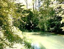 The Authie at Frohen-sur-Authie | |
 | |
| Native name | L'Authie (m) |
| Country | France |
| Basin | |
| Main source |
Picardie 131 m (430 ft) |
| River mouth |
English Channel 50°23′30″N 1°33′40″E / 50.39167°N 1.56111°ECoordinates: 50°23′30″N 1°33′40″E / 50.39167°N 1.56111°E |
| Basin size | 1,304 km2 (503 sq mi) |
| Physical characteristics | |
| Length | 103 km (64 mi) |
| Discharge |
|
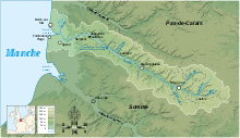
The Authie is a river in northern France whose 103-kilometre (64 mi) course crosses the departement of the Pas-de-Calais and the Somme. Its source is near the village of Coigneux. It flows through the towns of Doullens, Auxi-le-Château, Nempont-Saint-Firmin and Nampont, finally flowing out into the Channel near Berck. [1]
Its regular course has attracted mankind for many centuries, developing an agricultural environment that is still dominant today. The valley of the Authie, with many towns, villages, abbeys and chateaux, holds a rich architectural heritage alongside the banks of the river, while the river mouth forms a sizeable bay between Fort-Mahon-Plage and Berck, typical of Picardy estuaries. The area is home to a diverse range of flora and fauna.
Etymology
The origin of the name Authie has not been established with any certainty. A possibility is the pre-Celtic word atur meaning river.[2] Many waterways’ names, such as the Adour, are a corruption of the Celtic term alt meaning deep and that could refer to the steep-sided bed of the river.[3] Another suggestion stems from the Latin word attegia designating groups of fishermen and lumberjacks living by any river. .[4]
Hydrology

In the context of an oceanic/pluvial system, the Authie has a uniform and comparatively sustained outflow of 10.8 cubic metres per second (380 cu ft/s) at its outlet.[5] The river flow is affected by the oceanic climate, characterized by an average annual temperature of 10 °C (50 °F), very few days of frost, comparatively high rainfall between 800 and 900 mm (31 and 35 in) per year except near the coast estuary where rainfall is less than 650 mm (25.6 in) per year.[6]
Departements and communes traversed
- Pas-de-Calais (62) : Beauvoir-Wavans, Auxi-le-Château, Labroye, Groffliers, Nempont-Saint-Firmin and Berck.
- Somme (80): Coigneux, Authie, Authieule, Doullens, Hem-Hardinval, Boufflers, Dompierre-sur-Authie, Argoules, Nampont, Quend and Fort-Mahon-Plage.
Annexes
Bibliography
- Gérard Bacquet, Val d'Authie, Ed. Château, Auxi-le-Château, 1975 ASIN B0000DP6VS
- Eric Alibert, La Côte d'Opale, Carnet du Littoral, Gallimard - Conservatoire du littoral, 1998 ISBN 2-07-051467-6
External links
- Website of the Association for the development and promotion of the environment in the Val d'Authie.
- Aascalys (Aa, Scarpe,Canche, Authie, Lys) website dedicated to the rivers and countryside of Artois.
Notes and references
- ↑ Authie on the Sandre (Fr.Gov) website
- ↑ The origin of the name of the Authie
- ↑ The Authie: a valley, landscapes, a little history on cpie-authie.club.fr Read online
- ↑ The website of the town of Authie Archived September 27, 2007, at the Wayback Machine.
- ↑ The Authie Archived October 17, 2007, at the Wayback Machine. Artois-Picardy Water Agency website.
- ↑ French weather chart on Le Ponthieu et le Vimeu, by the Ministry of Agriculture Read online
| Wikimedia Commons has media related to Authie River. |