Parbold
| Parbold | |
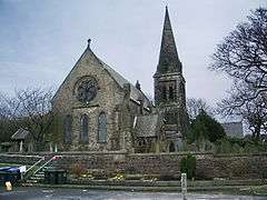 Christ Church, Douglas-in-Parbold |
|
 Parbold |
|
| Population | 2,582 (settlement) 3,784(ward) (2011 census) |
|---|---|
| OS grid reference | SD495115 |
| Civil parish | Parbold |
| District | West Lancashire |
| Shire county | Lancashire |
| Region | North West |
| Country | England |
| Sovereign state | United Kingdom |
| Post town | WIGAN |
| Postcode district | WN8 |
| Dialling code | 01257 |
| Police | Lancashire |
| Fire | Lancashire |
| Ambulance | North West |
| EU Parliament | North West England |
| UK Parliament | West Lancashire |
|
|
Coordinates: 53°35′35″N 2°45′50″W / 53.593°N 2.764°W
Parbold is a large commuter village and civil parish in the county of Lancashire, England.
Local government
The 210 acres (85 ha) of the 'urban settlement' of Parbold has a population of 2,700, reducing to 2,582 at the 2011 Census.[1] This settlement forms part of the larger Parbold ward (pop. 3,890),[2] reducing to 3,784 at the 2011 Census[3] one of 25 wards that make up West Lancashire Borough Council.
West Lancashire is also divided into 19 parish councils, the first tier of local government. Parbold Parish Council is bordered by the Hilldale Parish in the north, Wrightington in the east, Dalton in the south and Newburgh in the west.
Until the late 19th century, Parbold was part of the parish of Eccleston and the Leyland Hundred, or Leylandshire, an ancient subdivision of Lancashire that included Brindle, Chorley, Croston, Penwortham and Standish. From 1894 to 1974 Parbold was part of the Wigan Rural District, along with Dalton, Haigh, Shevington, Worthington and Wrightington.[4]
Location

Parbold lies in the valley of the River Douglas, at the bottom of Parbold Hill, about three miles west of junction 27 of the M6 motorway on the A5209. The village can also be reached by rail on the line from Manchester to Southport. Close to the village centre the Leeds and Liverpool Canal passes over the River Douglas. The nearest sizable towns are Skelmersdale (about 3 miles away 'as the crow flies'), Burscough (3½ miles), Ormskirk (6 miles), and Chorley (7 miles).
The village is dominated by Parbold Hill which rises to 400 feet above sea level.[5] On the hill lies the famous "Parbold Bottle", now restored. This is a stone monument about 6½ feet high, so called because it vaguely resembles a giant bottle. Built in 1832 to commemorate the Reform Act, the Bottle is visible from the canal.[6]

Also significant to Parbold's heritage is Wood Lane, just off the main road, and which arguably boasts some of the best views of the surrounding countryside.
History

The earliest known reference to Parbold is in the late 12th century, where grants of land were made to nearby Burscough Priory (pronounced Bursk-owe).[7] After the Norman conquest, Parbold was part of the Barony of Manchester. Little development occurred from this time to the mid 18th century. Parbold became a civil parish in 1894.[7]
During the 18th and 19th centuries, a number of coal mines worked nearby, rather meagre, seams; hard sandstone was also quarried. Both coal and sandstone could be exported over the waterways; boatbuilding was a minor economic activity in Parbold around this time.[7] The old windmill that is located next to the canal replaced an earlier water cornmill which once stood on Alder Lane, and was in use until 1985.[8]
Parbold railway station, built in the mid 19th century by the Lancashire and Yorkshire Railway, radically altered the village; it allowed middle class workers to live in Parbold and commute to urban areas throughout the north-west. In recent years a direct hourly service has operated to Manchester Airport railway station giving quick access (less than 1 hour and 15 minutes journey time) to flights from Manchester Airport. The railway station also provided a natural centre for the village which it still is today.[7]
Parbold's war memorial is in the local Anglican church, Christ Church, near the top of Parbold Hill. The village's other church – Our Lady and All Saints – was consecrated by Bishop Robert Cornthwaite on 28 May 1884.[9]
Amenities
Parbold has two churches, two primary schools and a nursery, a library built in 1989,[10] a purpose-built village hall which doubles as a cinema and community centre, a telephone exchange, a doctor's surgery, a bank, a sub post office and a number of other shops including a pharmacy, a newsagent, an estate agent, two hairdressers and both Chinese and Indian takeaways plus a greengrocery. There are three pubs along the main road through the centre of the village – the Railway, the Windmill and the Stocks Tavern. The windmill in the village was built in 1794 but has not milled since about 1850[7] and is now a gallery for James Bartholomew.[11] The bank is a branch of "The Royal Bank of Scotland" (having been formerly "Williams & Glyn's".)
Local sport
Parbold had a successful local amateur football team, Parbold FC (known as "the Cherries") who play in the South Lancashire Counties League. In 2005-06 they were crowned Division 3 Champions,[12] and promptly gained a further promotion in 2006-07 finishing runners-up of Division 2.[13] The 2009-10 season saw Parbold crowned Division 1 Champions and they now play in the Premier League. Although the team still bears the village name, they moved to Ormskirk in 2008 and connections to the village are few.
The nearest (as the "crow flies") professional football clubs are Wigan Athletic (8 miles), Preston North End (12 miles), Bolton Wanderers (14 miles), Everton and Liverpool (15 miles) and Blackburn Rovers (16 miles). The nearest professional rugby league clubs are Wigan (8 miles), St Helens (10 miles), Leigh (10 miles), Warrington (16 miles) and Widnes (16 miles).
Two semi-professional football clubs are significantly closer than the nearest professional club: Skelmersdale United (Northern Premier League Division One North) and Burscough (Conference North).
An annual fell race is run over Parbold Hill.[14] The 6¾ mile course includes tracks, roads and farmers’ fields. Runners can expect ".. mud and a large amount of climbing". In 2010 the race celebrated its 40th anniversary.
Notable residents
- The actress Dora Bryan was born in the village in 1923.[15]
- The composer Hugh Wood was born in Parbold in 1932.[16]
See also
References
- ↑ "Civil Ward population 2011". Retrieved 17 January 2016.
- ↑ 2001 United Kingdom census.
- ↑ "Ward population 2011". Retrieved 17 January 2016.
- ↑ "Greater Manchester Gazetteer". Greater Manchester County Record Office. Place Names T to W. Archived from the original on 18 July 2011.
- ↑ Welsh, Mary (2013). Walking in Lancashire: 40 Walks around the County. Cicerone Press Limited. ISBN 978-1849658232.
- ↑ Parbold. Information Britain
- 1 2 3 4 5 Virgoe, J. M. (1994). A History of Parbold. Carnegie. ISBN 978-0948789779.
- ↑ "Parbold". West Lancashire Borough Council.
- ↑ Beattie, Gordon (1997). Gregory's Angels. Gracewing Publishing. ISBN 978-0852443866.
- ↑ History of Parbold Library, County Library and Information Service.
- ↑ James Bartholomew RSMA. jamesbartholomew.co.uk
- ↑ Parbold FC - 2006/07. webteams.co.uk.
- ↑ Parbold FC - 2009/10. webteams.co.uk.
- ↑ Parbold Hill Race at skemboundaryharriers.co.uk
- ↑ The Times. Obituary. 24 July 2014
- ↑ Hugh Wood, Music Sales Classical, retrieved 18 November 2015
External links
| Wikimedia Commons has media related to Parbold. |
- Parbold Community Website
- Parbold FC
- Photographs of the Leeds & Liverpool Canal at Parbold
- Aerial photo of Parbold from Multimap.
- Parbold Surgery