Appley Bridge
| Appley Bridge | |
.jpg) The Leeds and Liverpool Canal, Appley Bridge |
|
 Appley Bridge |
|
| Population | 5,160 (2001 Census) |
|---|---|
| OS grid reference | SD531096 |
| Civil parish | Wrightington |
| District | West Lancashire |
| Shire county | Lancashire |
| Region | North West |
| Country | England |
| Sovereign state | United Kingdom |
| Post town | WIGAN |
| Postcode district | WN6 |
| Dialling code | 01257 |
| Police | Lancashire |
| Fire | Lancashire |
| Ambulance | North West |
| EU Parliament | North West England |
| UK Parliament | West Lancashire |
|
|
Coordinates: 53°34′44″N 2°43′16″W / 53.5790°N 2.7210°W
Appley Bridge is an affluent village in West Lancashire, England. It is located off Junction 27 of the M6 motorway and is nestled in the Douglas Valley alongside the Leeds and Liverpool Canal.
History
"Apple lea" (on the River Douglas), from (boscus de) Appelae, Appeleie, Appeleye, found in thirteenth century Chartulary of Cockersand Abbey; - also "Appley Moor"; within the township of Wrightington in the ancient parish of Eccleston.[1]
Community
Once a busy industrial village with a paint and linoleum works, several quarries, and clay pits for the Wigan brick company, today the village still has several factories including a weighbridge manufacturer and a caravan factory. Today it is not as busy, its main purpose being providing housing for the many commuters who work along the M6 corridor.
Appley Bridge has two churches, (Methodist and Church of England), and is in the Deanery of Chorley, Diocese of Blackburn.
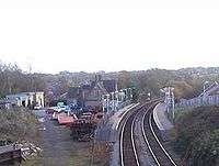
Appley Bridge railway station, opened in 1855 by the Lancashire & Yorkshire Railway, is situated on the Southport to Manchester line. The village contains a few convenience shops, a football ground, several country pubs, and a post office. Appley converges into the village of Shevington Vale[2] which is within the Greater Manchester border. In Shevington Vale (which is distinct from nearby Shevington), there is a range of amenities including a SPAR convenience store, a Chinese takeaway, a hairdressing salon, and a pharmacy. There is also a small children's play area and football pitch opposite the Shevington Vale primary school. The Golden Days garden centre is just outside the main village on Back Lane, near the M6 Motorway junction. A waste paper recycling yard is also present on Appley Lane North offering free disposal of cardboard and paper as well as other services.
Recreation
There are many open spaces in Appley Bridge where the local population play football, cricket, and rugby etc. The organized football team is called Appley Bridge FC and plays matches on the football pitch on Appley Lane South facing the old local pub called The Bridge Inn, near the Leeds and Liverpool Canal. Appley Bridge FC which is a Football Association Charter club has many junior teams from the under age 8 up to the under age 16. This is complemented by senior teams and a successful over-35 team. The Senior team enjoys good support and the junior teams have at various age groups been very successful over the past seasons.
19th Wigan Boys' Brigade and 1st Appley Bridge Girls' Brigade meet regularly at Vale Methodist Church Hall.
Appley Bridge Golf Club (now defunct) was founded in 1907. The club had disappeared by the early 1950s. [3]
Skull House Lane
In between Appley Lane North and Miles Lane is a road called Skull House Lane. The lane takes its name from a cottage known as Skull House, which is located about halfway down Appley Lane North.
An unreliable 'popular history' story asserts that in the time of the war between the Roundheads and the Cavaliers, Oliver Cromwell ordered that the monks of England should be driven out of their monasteries, killed, and their monasteries razed. One canny monk fled from his monastery and took refuge in a large cottage in Appley Bridge. Cromwell's Roundheads eventually discovered him in a cubby-hole halfway up the house's chimney, and tried to drive him out. They lit a blaze in the fireplace, forcing the monk out then killing him. The monk's discoloured skull has remained on the living room mantelpiece of the house.
Some inhabitants of Appley Bridge claim that throughout the history of the house, many residents have tried to get rid of the skull, and all have experienced disastrous results after doing so. According to the story, one threw it into the River Douglas at the bottom of Appley Lane North. Shortly after, the skull returned to the house and the offending resident drowned in the river. Another tried to get it as far away from the house as possible, and shortly after, the skull returned once again. The house's inhabitant fell down the stairs and severely injured himself. Others have tried many ways to banish the skull, and all have met with misfortune or fatality—sickness, the death of a loved one, bad luck ... the list goes on. The house's current residents have, unsurprisingly, never tried to remove the skull.
However, the story given about the origins of the name Skull House seems to be, at the least, confused, and probably apocryphal. The story about the monk and 'Oliver' Cromwell, although colourful, is based on a major confusion between Oliver Cromwell and Thomas Cromwell (no relation), the man who was responsible for the Dissolution of the Monasteries under Henry VIII. No monasteries remained in England at the time of the Civil War, and had not for more than a hundred years.
Recent tests, again rumour only, indicate that the skull is female, ruling out any connection with monks.
Appley Bridge meteorite
At around 8.45 on Tuesday evening of 13 October 1914, the inhabitants of Appley Bridge (indeed Lancashire and Cheshire too) were treated to a sudden and spectacular illumination of the night sky, caused by a meteorite that was found in a farmer's field in the village the following day. Found just 18 inches below the surface of the field, with the appearance of burnt iron, the small rock weighed almost 33 lb (15 kg). An article in the "Scientific News" (No. 2588, 30 October 1914) stated, "a small fragment which had been detached from the larger mass was put on view in a shop-window at Appley Bridge." In September 2014 a book about the meteorite, by local author Russell Parry, was published.
Millbank flood 1987


On 22 August 1987, parts of Appley Bridge were affected by severe flooding - worst affected was the Millbank estate, off Mill Lane.
During heavy rain, the entrance to the culvert that carries Calico Brook beneath the estate became blocked by debris (leaves, branches etc.) and overtopped into the estate, causing extensive flooding to most of the properties. Most residents spent the next few months - up to December '87 - in caravans parked on their front gardens, whilst repairs were carried out. The properties required extensive repair: re-plastering, new woodwork (doors, window frames etc.), with only the higher houses at the entrance to the estate being unaffected.
Here are quotes from a West Lancs District Council (WLDC) information item and a press release, dated 11 September 1987:
"When severe flooding occurred in several parts of the district on Saturday 22nd August 1987 - Parbold and parts of Skelmersdale were badly affected, whilst the Millbank estate in Appley Bridge was flooded out, with several houses being filled by water to first floor level and almost all of the remainder having water in their ground floor, varying from about two feet to five or six feet in depth. An amateur meteorologist with a weather station at Hilldale recorded the fall of 3.8 inches (97 mm) of rain during the 48 hours beginning at 8.00am on Saturday, 22nd August: over two thirds of that rainfall - about 2.6 inches - being in a four hour period on Saturday afternoon..."
"...From preliminary information, it would appear that the storm frequency was in the order of 1 in 75 year occurrence and this led to widespread flooding throughout the region..."
From information item presented to a meeting of the WLDC Technical Services Committee:
"...The most severe flooding incident was at Millbank Estate, Appley Bridge, where a 60" diameter piped culvert running through the estate could not cope with the sudden flow of surface water in the Calico brook. The brook overflowed the culvert and flooded the estate, which lies in a hollow, to a depth of about 8 feet [2.4 m]. at the lower end, approximately 40 houses being involved. The Fire Brigade were called to give assistance and they and the Police helped to evacuate the residents. The North West Water Authority Rivers Division also provided assistance with workmen and pumping equipment to pump the water away. The estate was not cleared of water until about Saturday midnight..."
Soon after the flood the council undertook simple remedial works to reduce the risk of further flooding. They were considered to be temporary works, with a permanent capital solution to follow. The works that were carried out consisted of the building of a restriction to flow, as part of a bridge across the stream in the local woods (known as "the slacks"), they also cut a "notch" into the quarry side wall. In the event of heavy rain, the stream will back-up against the restriction in the bridge and overflow through the notch into the nearby quarry. A wider spaced grill was also placed at the entrance to the culvert allowing small items, such as leaves, to pass through the culvert without blocking it.
In March 2012, twenty-four years after the flooding, work was finally started to replace the 1988 "temporary" works with a permanent project called the "Calico Brook Flood Risk Management Scheme".[4] This scheme of work has been completed, and consists of a concrete structure linked into an emergency overflow pipe. Normally, water passes through the structure and continues on to the brooks normal course, but in times of high discharge, the brook spills over into the emergency pipeline, which channels the water through a low-friction pipe directly to the River Douglas lower down the valley.
Notable people
- Darren Almond Artist
- Eva Pope Actress
- Theodore Major Artist
See also
References
- ↑ Eilert Eckwall, "The Place-Names of Lancashire", (1922, Manchester University Press: reprinted 1972 by EP Publishing, Wakefield) p. 130.
- ↑ http://www.bbc.co.uk/history/domesday/dblock/GB-352000-408000/page/6
- ↑ "Appley Bridge Golf Club", "Golf’s Missing Links".
- ↑ "Abbey Bridge Flood". Abbey Bridge Flood. Retrieved 5 November 2013.
External links
| Wikimedia Commons has media related to Appley Bridge. |
- West Lancashire Council
- Photographs of the Leeds Liverpool Canal at Appley Bridge towpathtreks.co.uk 2006
- All Saints CofE Church - Appley Bridge
- Shevington Parish Council
- Wigan Borough Council
- Wrightington Parish Council