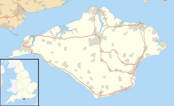
Ventnor
| Ventnor | |
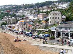 Ventnor seafront. |
|
 Ventnor |
|
| Population | 5,976 (2011 Census)[1] |
|---|---|
| OS grid reference | SZ562775 |
| Unitary authority | Isle of Wight |
| Ceremonial county | Isle of Wight |
| Region | South East |
| Country | England |
| Sovereign state | United Kingdom |
| Post town | VENTNOR |
| Postcode district | PO38 |
| Dialling code | 01983 |
| Police | Hampshire |
| Fire | Isle of Wight |
| Ambulance | Isle of Wight |
| EU Parliament | South East England |
| UK Parliament | Isle of Wight |
|
|
Coordinates: 50°35′51″N 1°12′30″W / 50.5976°N 1.2084°W
Ventnor (/ˈvɛntnər/) is a seaside resort and civil parish[2] established in the Victorian era on the south coast of the Isle of Wight, England. It is situated south of St Boniface Down (which, at 241 metres (791 feet), is the highest point on the island), and is built on steep slopes leading down to the sea. The higher part is referred to as Upper Ventnor (officially Lowtherville); the lower part, where most amenities are located, is known as Ventnor. Ventnor is sometimes taken to include the neighbouring settlements of St. Lawrence and Bonchurch .
Its relatively sheltered location beneath the downs produces a microclimate with more sunny days and fewer frosts than the rest of the island. This allows many species of subtropical plant to flourish; Ventnor Botanic Garden is particularly notable.
Geology
The local geomorphology defines the town. A significant area is built on clay, which suffers from serious landslip; the ground is notoriously unstable and many buildings and amenities have been lost to subsidence or cliff-falls. There is a local expression: "We live near the sea and are getting nearer every day".[3][4][5][6][7] A nearby Site of Special Scientific Interest is known as the Landslip.

The geological fault known as the Graben runs above the town. This marks the top of the series of landslips upon which Ventnor is built. The fault moves regularly, which has destroyed buildings over the years, led to serious cracking of local roads, and disrupted utilities. The latest evidence can be seen at the former bus stop in Ocean View Road, where a 5" by 3" vent has opened.[8]
Three miles off the coast, there is a parallel ridge under the sea rising to within 15 metres (49 ft) of the surface. The tidal flows along the Channel, forced between it and the island, have carved out a deep channel known as 'St. Catherine's Deep'.
History

The town grew from a small fishing hamlet in the 19th century, situated between the villages of Bonchurch and St Lawrence. Each of these villages was its own parish, but the area now occupied by Ventnor was divided between the parishes of Godshill and Newchurch.
Charles Dickens lived nearby for a time.
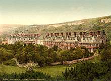
However, it was with the coming of the Isle of Wight Railway in 1866 that the town became both a tourist and a health resort. The fresh air and warm climate were considered beneficial to sufferers of tuberculosis, and several sanatoriums were established.
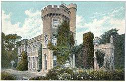
The Isle of Wight Railway at one time ran a non-stop train from Ryde to Ventnor, named 'The Invalid Express' for the consumptive patients being taken to treatment at Ventnor. One train famously completed the journey in a little over twenty minutes.[9] The town reached its zenith in 1930s, when steam packets operated between Southsea and the town's pier. The relatively small sandy beach was ideal for bathing, and is still popular today. Victorian era hotels in the town's suburbs and near the sea, such as Ventnor Towers Hotel, remain popular with tourists.
Transport
History of the railway
Ventnor railway station was the terminus of the Isle of Wight Railway (later the Island Line), and it brought many visitors to the town. Ventnor West railway station was the terminus of the Isle of Wight Central Railway from Cowes through Newport. Both stations suffered from being away from the town centre, requiring an onward road journey for travellers. Ventnor West Station was closed in 1952, before the closures ordered by Dr Beeching. Ventnor Station was closed in 1966, as part of a plan that also saw the remaining Ryde-Shanklin line electrified. Thereafter the town suffered economic decline from which it has not fully recovered.
Between 2004 and 2010 a 'rail link' bus by Wightbus ran from St Lawrence and Ventnor to Shanklin, facilitating the journey to and from Ventnor.[10]
Current bus services
Southern Vectis run buses on route 3 and 6 from Ventnor to destinations including Newport, Ryde, Sandown, Shanklin and Niton.[11] Additionally Island Minibus service run the local number 31 route which connects Ventnor to Bonchurch Village, the Botanic Garden and Esplanade. Previously operated by Wightbus, the link to the Esplanade was restored in 2011 after many years, despite suggestions that this would be impractical.[12]
Ventnor Botanic Garden
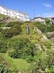
Ventnor Botanic Garden occupies the site of the former Royal National Hospital for Chest Diseases, and has a variety of tropical plants. Annual rainfall of 31 inches (790 mm) and a particularly warm and sunny microclimate allows a variety of plants normally too tender for mainland Britain to grow. The garden includes plants from across the world, particularly Australia and New Zealand, but also from Japan and the Mediterranean. There is a temperate house, and a visitor centre renovated in 2001.
Other places of interest

- Ventnor Park is on the western side of town and has a bandstand, aviary and stream, a putting green open seasonally, and live music on Sunday afternoons during the summer.
- The Cascade Gardens This garden with a waterfall, known as the cascade, was laid out in 1903.[13] Below is a paddling-pool on the esplanade with a model of the Isle of Wight that children can play on.
- VENTNOR Sign: This is on the cliffs at La Falaise, west of the beach, with the town's name in 4 metres (13 ft) tall white concrete blocks. It was intended to provide a landmark visible from the sea, and replaced the chalk letters damaged in 1992.
- Ventnor Brewery: A brewery has been on the same location since the 1840s. Water from the local spring "St Boniface's Well" is used to make beer.[14] The town was also home to Burt's Brewery, which closed in the 1980s; in 1996 it reopened as a microbrewery called the "Ventnor Brewery", which produced cask ales including Oyster Stout. It closed in 2009.[15]
- RAF Ventnor High above the town is the site of the former RAF Ventnor, once a radar monitoring station. Now it is used for civilian communications antennae, but also contains bunkers that were part of an early warning network, later converted into nuclear shelters during the Cold War. The bunker, a variant on the P1 ROTOR design, is now sealed and inaccessible, although planning permission was granted in 2015 for conversion into a holiday property.
- Ventnor Exchange is an arts centre that opened in 2014 in the old Post Office building on Church Street.[16] It organises the annual Ventnor Fringe Festival and supports emerging artists.
- Ventnor is on the Isle of Wight Coastal Path.
Climate
Ventnor and the Isle of Wight has a maritime climate with cool summers and mild winters. The Met Office maintain a weather station at Ventnor Park. Because of its coastal location, Ventnor currently holds the English record for the warmest nights for the months of...
- May; 17.8 °C (64.0 °F) in 1989.
- June; 22.7 °C (72.9 °F) in 1976
- July, 22.6 °C (72.7 °F) again in 1976[17]
- and second warmest night on record in August,23.2 °C (73.8 °F) during 2003[18]
| Climate data for Ventnor Park 60m asl, 1971-2000 | |||||||||||||
|---|---|---|---|---|---|---|---|---|---|---|---|---|---|
| Month | Jan | Feb | Mar | Apr | May | Jun | Jul | Aug | Sep | Oct | Nov | Dec | Year |
| Average high °C (°F) | 7.9 (46.2) |
7.8 (46) |
9.8 (49.6) |
12.0 (53.6) |
15.2 (59.4) |
17.5 (63.5) |
19.7 (67.5) |
20.1 (68.2) |
18.1 (64.6) |
14.9 (58.8) |
11.2 (52.2) |
9.0 (48.2) |
13.6 (56.48) |
| Average low °C (°F) | 3.6 (38.5) |
3.2 (37.8) |
4.4 (39.9) |
5.6 (42.1) |
8.7 (47.7) |
11.3 (52.3) |
13.6 (56.5) |
14.1 (57.4) |
12.4 (54.3) |
9.9 (49.8) |
6.5 (43.7) |
4.7 (40.5) |
8.17 (46.71) |
| Source: YR.NO[19] | |||||||||||||
Wall lizard
The largest British colony of common wall lizards lives in the town; a wall specially designed as a habitat was built at the Botanic Garden.[20]
Events
- Ventnor Fringe Festival: Held annually since 2010, this is an open arts festival taking place in venues across the town, similarly to the Edinburgh Festival Fringe. Previous acts include Liam Bailey, Marques Toliver, Johnny Flynn and Vincent Moon as well as theatre companies such as Paines Plough. The Fringe coincides with the Ventnor Carnival and, since 2012, the Isle of Wight Film Festival. In 2013 it expanded with the introduction of camping for visitors at Ventnor Rugby Club.
- Carnival: This is a traditional town carnival, held in the middle of August, with carnival floats, marching bands and drinking.
- Isle of Wight International Jazz Festival: The 3-day festival was held from 2005-08. Headline acts included Maceo Parker, Humphrey Lyttelton and Cleo Laine.
- Isle of Arts - annual festival
Churches
Ventnor Baptist Church
Education
Schools in Ventnor include:
- St. Francis Church Aided Primary School
- St. Catherine's School, a special school for pupils with speech and language difficulties.
- The Isle Of Wight Free School (secondary education)
Media references
- The band the Bees are from Ventnor.
- The actor Brian Murphy was born in Ventnor.
Other places named after Ventnor
- Ventnor is a seaside area on the north of Phillip Island, off the southern coast of Australia.
- Ventnor City is a coastal city in New Jersey adjacent to Atlantic City.
References
- ↑ "Resort population 2011". Retrieved 19 October 2015.
- ↑ English Parishes & Welsh Communities N&C 2004 Archived 9 January 2007 at the Wayback Machine.
- ↑ Landslips on The Isle of Wight
- ↑ West & South Isle of Wight, Standing Conference on Problems Associated with the Coastline.
- ↑ LUCCOMBE - BLACKGANG ISLE OF WIGHT (UNITED KINGDOM), Robin G. McGiness, Isle of Wight Centre for Coastal Environment
- ↑ Life on the Edge, Undercliff Matters, English Nature, Issue 2, September 2003.
- ↑ Isle of Wight Coastal Visitors Centre
- ↑ "Hole in road is growing say residents". Iwcp.co.uk. 2011-01-27. Retrieved 2013-09-17.
- ↑ Liberty and Locality: Parliament, Permissive Legislation and Ratepayers' Democracies in the Nineteenth Century, John M. Prest, Clarendon Press, 1990
- ↑ "New bus link boost for Ventnor". Isle of Wight County Press. Retrieved 2009-12-22.
- ↑ "Southern Vectis route list". Southern Vectis. Archived from the original on 30 November 2009. Retrieved 2009-12-22.
- ↑ "Isle of Wight County Press - "Ventnor needs better buses"". www.iwcp.co.uk. Retrieved 2009-03-18.
- ↑ Ventnor Heritage: Places in Ventnor
- ↑ St Boniface's Well (Ventnor), The Megalithic Portal.
- ↑ Ventnor Blog: Ventnor Brewery closes
- ↑ "About the Exchange". Ventnor Exchange. Retrieved 2016-01-13.
- ↑ "Night minimum records, May, June, July". UKMO.
- ↑ "August 2003 Night Minimum record". UKMO.
- ↑ "Ventnor Climate". YR.NO. Retrieved 9 Nov 2011.
- ↑ "Gift to Nature - What we do - Ventnor Lizard Wall". Retrieved 2008-08-20.
External links
| Wikimedia Commons has media related to Ventnor. |
| Wikivoyage has a travel guide for Ventnor. |
- IOW Council beach information
- The history of Ventnor's Winter Gardens building overlooking the Eastern Esplanade
- Old pictures of Ventnor
Isle of Wight Portal | |
| Unitary authorities | |
| Major settlements | |
| Rivers | |
| Topics | |