| Name |
Area |
Established |
Location |
Coordinates |
| Aurora Memorial National Park |
7007567600000000000♠5,676.00 ha
(14,025.7 acres) |
1937 |
|
15°35′03″N 121°24′00″E / 15.58423°N 121.39990°E / 15.58423; 121.39990 (Aurora Memorial National Park) |
| Balbalasang-Balbalan National Park |
7007133800000000000♠1,338.00 ha
(3,306.3 acres) |
1972 |
Kalinga |
17°27′00″N 121°09′00″E / 17.45000°N 121.15000°E / 17.45000; 121.15000 (Balbalasang-Balbalan National Park) |
| Bangan Hill National Park |
7005139000000000000♠13.90 ha
(34.3 acres) |
1995 |
Nueva Vizcaya |
16°29′00″N 121°09′00″E / 16.48333°N 121.15000°E / 16.48333; 121.15000 (Bangan Hill National Park) |
| Bataan National Park |
7008236880000000000♠23,688.00 ha
(58,534.3 acres) |
1945 |
Bataan |
14°36′22″N 120°30′31″E / 14.60602°N 120.50848°E / 14.60602; 120.50848 (Bataan National Park) |
| Biak-na-Bato National Park |
7007211700000000000♠2,117.00 ha
(5,231.2 acres) |
1937 |
Bulacan |
15°07′08″N 121°05′06″E / 15.11875°N 121.08510°E / 15.11875; 121.08510 (Biak-na-Bato National Park) |
| Bulabog Putian National Park |
7006854330000000000♠854.33 ha
(2,111.1 acres) |
1961 |
Iloilo |
11°02′01″N 122°40′02″E / 11.03370°N 122.66730°E / 11.03370; 122.66730 (Bulabog Putian National Park) |
| Caramoan National Park |
7006347000000000000♠347.00 ha
(857.5 acres) |
1938 |
Camarines Sur |
13°46′49″N 123°52′49″E / 13.78036°N 123.88020°E / 13.78036; 123.88020 (Caramoan National Park) |
| Cassamata Hill National Park |
7005570000000000000♠57.00 ha
(140.9 acres) |
1974 |
Abra |
17°35′28″N 120°37′17″E / 17.59122°N 120.62143°E / 17.59122; 120.62143 (Cassamata Hill National Park) |
| Fuyot Springs National Park |
7006819000000000000♠819.00 ha
(2,023.8 acres) |
1938 |
Isabela |
17°12′40″N 122°00′56″E / 17.21116°N 122.01555°E / 17.21116; 122.01555 (Fuyot Springs National Park) |
| Guadalupe Mabugnao Mainit Hot Spring National Park |
7005575000000000000♠57.50 ha
(142.1 acres) |
1972 |
Cebu |
10°08′01″N 123°36′00″E / 10.13357°N 123.60009°E / 10.13357; 123.60009 (Guadalupe Mabugnao Mainit Hot Spring National Park) |
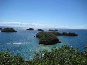
| Hundred Islands National Park |
7007167630000000000♠1,676.30 ha
(4,142.2 acres) |
1940 |
Pangasinan |
16°12′02″N 120°02′15″E / 16.20050°N 120.03763°E / 16.20050; 120.03763 (Hundred Islands National Park) |
| Kuapnit Balinsasayao National Park |
7006364000000000000♠364.00 ha
(899.5 acres) |
1937 |
Leyte |
10°38′45″N 124°55′13″E / 10.64581°N 124.92034°E / 10.64581; 124.92034 (Kuapnit Balinsasayao National Park) |
| Lake Butig National Park |
7005680000000000000♠68.00 ha
(168.0 acres) |
1965 |
Lanao del Sur |
7°44′07″N 124°17′19″E / 7.73523°N 124.28869°E / 7.73523; 124.28869 (Lake Butig National Park) |
| Lake Dapao National Park |
7007150000000000000♠1,500.00 ha
(3,706.6 acres) |
1965 |
Lanao del Sur |
7°47′16″N 124°02′51″E / 7.78782°N 124.04743°E / 7.78782; 124.04743 (Lake Dapao National Park) |
| Libmanan Caves National Park |
7005194000000000000♠19.40 ha
(47.9 acres) |
1934 |
Camarines Sur |
13°39′00″N 122°48′00″E / 13.65000°N 122.80000°E / 13.65000; 122.80000 (Libmanan Caves National Park) |
| Luneta National Park |
7005162399999999999♠16.24 ha
(40.1 acres) |
1955 |
Metro Manila |
14°35′00″N 120°58′42″E / 14.58325°N 120.97831°E / 14.58325; 120.97831 (Luneta National Park) |
| MacArthur Landing Memorial National Park |
7004678000000000000♠6.78 ha
(16.8 acres) |
1977 |
Leyte |
11°10′19″N 125°00′45″E / 11.17207°N 125.01244°E / 11.17207; 125.01244 (MacArthur Landing Memorial National Park) |
| Mado Hot Spring National Park |
7005480000000000000♠48.00 ha
(118.6 acres) |
1939 |
Cotabato |
7°13′00″N 124°15′00″E / 7.21667°N 124.25000°E / 7.21667; 124.25000 (Mado Hot Spring National Park) |
| Minalungao National Park |
7007201800000000000♠2,018.00 ha
(4,986.6 acres) |
1967 |
Nueva Ecija |
15°18′27″N 121°08′33″E / 15.30738°N 121.14240°E / 15.30738; 121.14240 (Minalungao National Park) |
| Mount Arayat National Park |
7007371523000000000♠3,715.23 ha
(9,180.5 acres) |
1933 |
Pampanga |
15°12′13″N 120°43′45″E / 15.20373°N 120.72925°E / 15.20373; 120.72925 (Mount Arayat National Park) |
| Mount Dajo National Park |
7006213350000000000♠213.35 ha
(527.2 acres) |
1938 |
Sulu |
6°00′47″N 121°03′13″E / 6.01293°N 121.05358°E / 6.01293; 121.05358 (Mount Dajo National Park) |
Mount Data National Park
(Baguio-Bontoc Scenic National Park) |
7007551200000000000♠5,512.00 ha
(13,620.4 acres) |
1936 |
|
16°52′41″N 120°50′18″E / 16.87804°N 120.83841°E / 16.87804; 120.83841 (Mount Data National Park) |
| Mounts Iglit–Baco National Park |
7008754550000000000♠75,455.00 ha
(186,453.4 acres) |
1969 |
Mindoro Occidental |
12°44′36″N 121°07′31″E / 12.74340°N 121.12521°E / 12.74340; 121.12521 (Mounts Iglit–Baco National Park) |
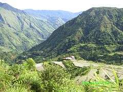
| Mount Pulag National Park |
7008115500000000000♠11,550.00 ha
(28,540.7 acres) |
1987 |
|
16°35′01″N 120°53′01″E / 16.58357°N 120.88359°E / 16.58357; 120.88359 (Mount Pulag National Park) |
| Naujan Lake National Park |
7008216550000000000♠21,655.00 ha
(53,510.7 acres) |
1956 |
Mindoro Oriental |
13°10′22″N 121°20′34″E / 13.17270°N 121.34273°E / 13.17270; 121.34273 (Naujan Lake National Park) |
| Northern Luzon Heroes Hill National Park |
7007131600000000000♠1,316.00 ha
(3,251.9 acres) |
1963 |
Ilocos Sur |
17°29′10″N 120°27′11″E / 17.48614°N 120.45305°E / 17.48614; 120.45305 (Northern Luzon Heroes Hill National Park) |
| Olongapo Naval Base Perimeter National Park |
7004903999999999999♠9.04 ha
(22.3 acres) |
1968 |
Zambales |
14°49′37″N 120°17′10″E / 14.82685°N 120.28599°E / 14.82685; 120.28599 (Olongapo Naval Base Perimeter National Park) |
| Pagsanjan Gorge National Park |
7006152639999999999♠152.64 ha
(377.2 acres) |
1939 |
Laguna |
14°16′00″N 121°29′00″E / 14.26667°N 121.48333°E / 14.26667; 121.48333 (Pagsanjan Gorge National Park) |
| Pantuwaraya Lake National Park |
7005200000000000000♠20.00 ha
(49.4 acres) |
1965 |
Lanao del Sur |
8°02′00″N 124°16′00″E / 8.03333°N 124.26667°E / 8.03333; 124.26667 (Pantuwaraya Lake National Park) |
| Paoay Lake National Park |
7006340000000000000♠340.00 ha
(840.2 acres) |
1969 |
Ilocos Norte |
18°07′16″N 120°32′12″E / 18.12114°N 120.53654°E / 18.12114; 120.53654 (Paoay Lake National Park) |
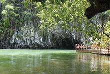
| Puerto Princesa Subterranean River National Park |
7008222020000000000♠22,202.00 ha
(54,862.3 acres) |
1999 |
Palawan |
10°10′00″N 118°55′00″E / 10.1667°N 118.9167°E / 10.1667; 118.9167 (Puerto Princesa Subterranean River National Park) |
| Quezon Memorial National Park |
7005227000000000000♠22.70 ha
(56.1 acres) |
1975 |
Metro Manila |
14°39′04″N 121°02′57″E / 14.65110°N 121.04928°E / 14.65110; 121.04928 (Quezon Memorial National Park) |
| Rungkunan National Park |
undetermined |
1965 |
Lanao del Sur |
8°03′40″N 124°24′11″E / 8.06100°N 124.40318°E / 8.06100; 124.40318 (Rungkunan National Park) |
| Sacred Mountain National Park |
7005940000000000000♠94.00 ha
(232.3 acres) |
1965 |
Lanao del Sur |
8°01′16″N 124°17′47″E / 8.02120°N 124.29633°E / 8.02120; 124.29633 (Sacred Mountain National Park) |
| Salikata National Park |
undetermined |
1965 |
Lanao del Sur |
7°52′14″N 124°21′32″E / 7.87046°N 124.35879°E / 7.87046; 124.35879 (Salikata National Park) |


 Media related to National parks of the Philippines at Wikimedia Commons