Sausalito, California
| City of Sausalito | |
|---|---|
| City | |
|
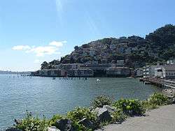
Sausalito combines hillside with shoreline, as seen in this view from Bridgeway, the city's central street. | |
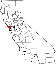
 Location in Marin County and the state of California | |
 Sausalito Location in the United States | |
| Coordinates: 37°51′33″N 122°29′07″W / 37.85917°N 122.48528°WCoordinates: 37°51′33″N 122°29′07″W / 37.85917°N 122.48528°W | |
| Country | United States |
| State | California |
| County | Marin |
| Incorporated | September 4, 1893[1] |
| Government | |
| • Mayor | Thomas Theodores[2] |
| • State Senator | Mike McGuire (D)[3] |
| • Assemblymember | Marc Levine (D)[3] |
| • U. S. Rep. | Jared Huffman (D)[4] |
| • Supervisor |
District 3 Charles McGlashan |
| Area[5] | |
| • Total | 2.257 sq mi (5.846 km2) |
| • Land | 1.771 sq mi (4.586 km2) |
| • Water | 0.486 sq mi (1.259 km2) 21.54% |
| Elevation[6] | 10 ft (3 m) |
| Population (April 1, 2010)[7] | |
| • Total | 7,061 |
| • Estimate (2013)[7] | 7,099 |
| • Density | 3,100/sq mi (1,200/km2) |
| Time zone | Pacific Time Zone (UTC−8) |
| • Summer (DST) | PDT (UTC−7) |
| ZIP codes | 94965, 94966 |
| Area codes | 415/628 |
| FIPS code | 06-70364 |
| GNIS feature IDs | 277597, 2411834 |
| Website |
www |
Sausalito is a San Francisco Bay Area city in Marin County, California. Sausalito is 8 miles (13 km) south-southeast of San Rafael,[8] at an elevation of 13 feet (4 m).[6] The population was 7,061 as of the 2010 census. The community is situated near the northern end of the Golden Gate Bridge, and prior to the building of that bridge served as a terminus for rail, car, and ferry traffic. Developed rapidly as a shipbuilding center in World War II, the city's industrial character gave way in postwar years to a reputation as a wealthy and artistic enclave, a picturesque residential community (incorporating large numbers of houseboats), and a tourist destination. It is adjacent to, and largely bounded by, the protected spaces of the Golden Gate National Recreation Area.
Etymology
The name of Sausalito comes from Spanish sauzalito, meaning "small willow grove", from sauce "willow" + collective derivative -al meaning "place of abundance" + diminutive suffix -ito; with orthographic corruption from z to s due to seseo; early variants of the name were Saucelito, San Salita, San Saulito, San Salito, Sancolito, Sancilito, Sousolito, Sousalita, Sousilito, Sausilito, and Sauz Saulita.[8]
It is sometimes claimed that Sausalito was named for the district in Valparaíso, Chile where the bandit Joaquín Murrieta was born. Murrieta was the leader of bandits who settled at the northern end of the future Golden Gate bridge after being banned from San Francisco in the bandit wars. However, this theory cannot be true because Murrieta was from Mexico, not Chile, and because he did not arrive in California until the Gold Rush around 1849.[9] The Rancho Saucelito had already been granted to William Richardson in 1838.[10]
Geography
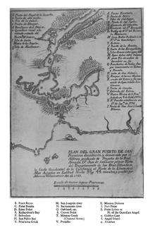
Located at 37°51′33″N 122°29′07″W / 37.85917°N 122.48528°W,[6] Sausalito encompasses both steep, wooded hillside and shoreline tidal flats. According to the United States Census Bureau, the city has a total area of 2.2 square miles (5.7 km2). Notably, only 1.8 square miles (4.7 km2) of it is land. A full 21.54% of the city (0.5 square miles, or 1.3 km²) is under water, and has been so since its founding in 1868. Prominent geographic features associated with Sausalito include Richardson Bay and Pine Point.
When Sausalito was formally platted, it was anticipated that future development might extend the shoreline with landfill, as had been the practice in neighboring San Francisco. As a result, entire streets, demarcated and given names like Pescadero, Eureka and Teutonia, remain beneath the surface of Richardson Bay.[11] The legal, if not actual, presence of these streets has proved a contentious factor in public policy, because some houseboats float directly above them. According to the San Francisco Chronicle, "State agencies say privately owned houseboats can't be located above the underwater streets because the streets are public trust lands intended for public benefit." The California State Lands Commission is reportedly pursuing a compromise which would move not the houseboats, but the theoretical streets instead.[12]
Climate
Sausalito has a Mediterranean climate (Köppen climate classification Csb) with far lower temperatures than expected because of its adjacency to San Francisco Bay and the resultant onshore breezes.
| Climate data for Sausalito, California | |||||||||||||
|---|---|---|---|---|---|---|---|---|---|---|---|---|---|
| Month | Jan | Feb | Mar | Apr | May | Jun | Jul | Aug | Sep | Oct | Nov | Dec | Year |
| Average high °F (°C) | 57 (14) |
60 (16) |
62 (17) |
63 (17) |
64 (18) |
67 (19) |
67 (19) |
68 (20) |
70 (21) |
69 (21) |
63 (17) |
57 (14) |
63.9 (17.8) |
| Average low °F (°C) | 46 (8) |
48 (9) |
49 (9) |
49 (9) |
51 (11) |
53 (12) |
54 (12) |
55 (13) |
55 (13) |
54 (12) |
50 (10) |
46 (8) |
50.8 (10.5) |
| Average precipitation inches (mm) | 4.50 (114.3) |
3.61 (91.7) |
3.26 (82.8) |
1.46 (37.1) |
.70 (17.8) |
.16 (4.1) |
0 (0) |
.06 (1.5) |
.21 (5.3) |
1.12 (28.4) |
3.16 (80.3) |
4.56 (115.8) |
22.80 (579.1) |
| Source: Weather Channel [13] | |||||||||||||
History
Indigenous culture
Sausalito was once the site of a Coast Miwok settlement known as Liwanelowa. The branch of the Coast Miwok living in this area were known as the Huimen (or as Nación de Uimen to the Spanish).[14][15] Early explorers of the area described them as friendly and hospitable. According to Juan de Ayala, "To all these advantages must be added the best of all, which is that the heathen Indians of the port are so faithful in their friendship and so docile in their disposition that I was greatly pleased to receive them on board." Such placidity was likely a contributing factor to their complete displacement, which took place within the span of a few generations. As historian Jack Tracy has observed, "Their dwellings on the site of Sausalito were explored and mapped in 1907, nearly a century and a half later, by an archaeological survey. By that time, nothing was left of the culture of those who had first enjoyed the natural treasures of the bay. The life of the Coastal Miwoks had been reduced to archaeological remnants, as though thousands of years had passed since their existence."
European arrival and settlement
The first European known to visit the present-day location of Sausalito was Don José de Cañizares, on August 5, 1775. Cañizares was head of an advance party dispatched by longboat from the ship San Carlos, searching for a suitable anchorage for the larger vessel. The crew of the San Carlos came ashore soon after, reporting friendly natives and teeming populations of deer, elk, bear, sea lions, seals and otters. More significantly for maritime purposes, they reported an abundance of large, mature timber in the hills, a valuable commodity for shipwrights in need of raw materials for masts, braces and planking.
Despite these and later positive reports, the Spanish colonial government of Upper California did little to establish a presence in the area. When a military garrison (now the Presidio of San Francisco) and a Franciscan mission (Mission Dolores) were founded the following year, they were situated on the opposite, southern shore of the bay, where no portage was necessary for overland traffic to and from Monterey, the regional capitol. As a result, the far shore of the Golden Gate strait would remain largely wilderness for another half-century.
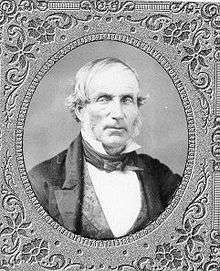
The development of the area began at the instigation of William A. Richardson, who arrived in Upper California in 1822, shortly after Mexico had won its independence from Spain. An English mariner who had picked up a fluency in Spanish during his travels, he quickly became an influential presence in the now-Mexican territory. By 1825, Richardson had assumed Mexican citizenship, converted to Catholicism and married the daughter of Don Ignacio Martínez, commandant of the Presidio and holder of a large land grant. His ambitions now expanding to land holdings of his own, Richardson submitted a petition to Governor Echienda for a rancho in the headlands across the water from the Presidio, to be called "Rancho Saucelito".[10] Sausalito is believed to refer to a small cluster of willows, a most-soil tree, indicating the presence of a freshwater spring.[16]
Even before filing his claim, Richardson had used the spring as a watering station on the shores of what is now called Richardson Bay (an arm of the larger San Francisco Bay), selling fresh water to visiting vessels. However, his ownership of the land was legally tenuous: other claims had been submitted for the same region, and at any rate Mexican law reserved headlands for military uses, not private ownership. Richardson temporarily abandoned his claim and settled instead outside the Presidio, building the first permanent civilian home and laying out the street plan for the pueblo of Yerba Buena (present-day San Francisco). After years of lobbying and legal wrangling, Richardson was given clear title to all 19,751 acres (79.93 km2) of Rancho del Sausalito on February 11, 1838.
Fishing village and sybaritic enclave
In the post-Gold Rush era, Sausalito's unusual location became a key factor in its formation as a community. It was San Francisco's nearest neighbor, less than two miles (3 km) away at the nearest point and easily seen from city streets, yet transportation factors rendered it effectively isolated. A boat could sail there in under half an hour, but wagons and carriages required an arduous skirting of the entire bay, a journey that could well exceed a hundred miles. As a result, the region was largely dominated by two disparate classes of people, both with ready access to boats: commercial fishermen and wealthy yachting enthusiasts.
Transit hub
The first post office opened in 1870 as "Saucelito" and changed its name to the present spelling in 1887.[8]
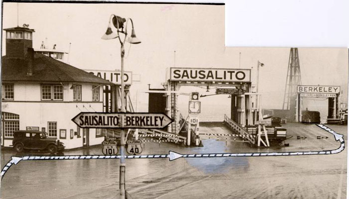
.JPG)
In the 1870s, the North Pacific Coast Railroad (NPC) extended its tracks southward to a new terminus in Sausalito, where a rail yard and ferry to San Francisco were established. The NPC was acquired by the North Shore Railroad in 1902, which in turn was absorbed in 1907 by the Southern Pacific affiliate, the Northwestern Pacific.
By 1926, a major auto ferry across the Golden Gate was established, running to the Hyde Street Pier in San Francisco.[17] This ferry was an integral part of old U.S. Highway 101, and a large influx of automobile traffic, often parked or idling in long queues, became a dominant characteristic of the town. Northwestern Pacific commuter train service also expanded to serve the increased traffic volume, and Sausalito became known primarily as a transportation hub.
This era came to an end in May 1937, with the opening of the Golden Gate Bridge. The bridge made large-scale ferry operations redundant, and since the new route of Highway 101 bypassed Sausalito entirely, in-town traffic was quickly reduced to a trickle. Car ferry service ended in March 1941 (passenger ferry service, however, continues to this day, linking downtown Sausalito with both the Ferry Building in San Francisco's Embarcadero, and Pier 39 in the Fisherman's Wharf district). Northwestern Pacific also closed its Sausalito terminal in March 1941, although some tracks remained in use as "spur tracks" for freight trains as late as 1971.[16]
Bootlegging and Rum Runners
Sausalito was a center for bootlegging during the era of Prohibition in the United States. Because of its location facing the Golden Gate and isolated from San Francisco by the same waterway, it was also a favorite landing spot for rum runners.[18] The 1942 film China Girl has some footage of Sally Stanford's Valhalla restaurant on the waterfront. The scene shows the docks and illustrates rum running.
Industrialization during World War II
When the United States entered World War II, Fort Barry on Point Bonita was reoccupied. Fort Baker also hosted large numbers of troops. Barracks and other housing were constructed for soldiers. Few of these buildings remain.[19]
A major shipyard of the Bechtel Corporation called Marinship was sited along the shoreline of Sausalito. The thousands of laborers who worked here were largely housed in a nearby community constructed for them called Marin City. The soil which supports this area is dredgings from Richardson Bay that were placed during World War II as part of the Marin shipyards for the United States Navy.[20] A total of 202 acres (0.8 km2) were condemned by the government. A portion of this total area was formed in the shape of a peninsula and this peninsula became known as Schoonmaker Point. In honor of the city's contribution to the war effort, a Tacoma-class frigate was christened the USS Sausalito (PF-4) in 1943. The ship Sausalito, however, was not built in Sausalito but at one of the Kaiser Shipyards in Richmond, California, also on the San Francisco Bay.
The Marinship Shipyards were the site of incidents that provided a key early milestone in the Civil rights movement.[21] In 1944 in the case of James v. Marinship the California Supreme Court held that African Americans could not be excluded from jobs based on their race, even if the employer took no discriminatory actions. In the case of Joseph James, on whose behalf the suit was brought, the local Boilermakers Union excluded Blacks from membership and had a "closed shop" contract, forbidding the shipbuilder from employing anyone who was not a member of the union. African American workers could join an auxiliary of the union, which offered access to fewer jobs at lower pay. Future US Supreme Court justice Thurgood Marshall successfully argued the case, winning a ruling that the union be required to offer equal membership to African Americans. The Court extended the ruling to apply explicitly to all unions and all workers in California.
Postwar Sausalito

Following World War II, a lively waterfront community grew out of the abandoned ship yards. By the late 1960s at least three house boat communities occupied the waterfront along and adjacent to Sausalito's shore. Beginning in the 1970s, an intense struggle erupted between house boat residents and developers. It was dubbed the "House Boat Wars".[22] Forced removals by county authorities and sabotage by some on the waterfront characterized this struggle. This long fight pitted the waterfront against the "Hill People" or the rich on the hill looking down on the water front. Today three house boat communities still exist — Galilee Harbor in Sausalito, Waldo Point Harbor and the Gates Cooperative, just outside the city limit.
In 1965, the City of Sausalito sued the County of Marin and a private developer for illegally zoning 2,000 acres (809 ha) of land to build a city named Marincello adjacent to Sausalito. The city won the lawsuit in 1970, and the land was transferred as open space to the Golden Gate National Recreation Area.
Government
Federal and state
In the United States House of Representatives, Sausalito is in California's 2nd congressional district, represented by Democrat Jared Huffman.[23] From 2008 to 2012, Huffman represented Marin County in the California State Assembly.
In the California State Legislature, Sausalito is in:
- the 10th Assembly District, represented by Democrat Marc Levine[24]
- the 2nd Senate District, represented by Democrat Mike McGuire.
Demographics
| Historical population | |||
|---|---|---|---|
| Census | Pop. | %± | |
| 1880 | 476 | — | |
| 1890 | 1,334 | 180.3% | |
| 1900 | 1,628 | 22.0% | |
| 1910 | 2,383 | 46.4% | |
| 1920 | 2,790 | 17.1% | |
| 1930 | 3,667 | 31.4% | |
| 1940 | 354 | −90.3% | |
| 1950 | 4,828 | 1,263.8% | |
| 1960 | 5,331 | 10.4% | |
| 1970 | 6,158 | 15.5% | |
| 1980 | 7,338 | 19.2% | |
| 1990 | 7,152 | −2.5% | |
| 2000 | 7,330 | 2.5% | |
| 2010 | 7,061 | −3.7% | |
| Est. 2015 | 7,156 | [25] | 1.3% |
2010
The 2010 United States Census[27] reported that Sausalito had a population of 7,061. The population density was 3,128.5 people per square mile (1,207.9/km²). The racial makeup of Sausalito was 6,400 (90.6%) White, 65 (0.9%) African American, 16 (0.2%) Native American, 342 (4.8%) Asian, 10 (0.1%) Pacific Islander, 53 (0.8%) from other races, and 175 (2.5%) from two or more races. Hispanic or Latino of any race were 287 persons (4.1%).
The Census reported that 99.8% of the population lived in households and 0.2% lived in non-institutionalized group quarters.
There were 4,112 households, out of which 420 (10.2%) had children under the age of 18 living in them, 1,443 (35.1%) were opposite-sex married couples living together, 146 (3.6%) had a female householder with no husband present, 64 (1.6%) had a male householder with no wife present. There were 313 (7.6%) unmarried opposite-sex partnerships, and 63 (1.5%) same-sex married couples or partnerships. 1,927 households (46.9%) were made up of individuals and 524 (12.7%) had someone living alone who was 65 years of age or older. The average household size was 1.71. There were 1,653 families (40.2% of all households); the average family size was 2.39.
The population was spread out with 615 people (8.7%) under the age of 18, 159 people (2.3%) aged 18 to 24, 1,962 people (27.8%) aged 25 to 44, 2,830 people (40.1%) aged 45 to 64, and 1,495 people (21.2%) who were 65 years of age or older. The median age was 51.1 years. For every 100 females there were 90.2 males. For every 100 females age 18 and over, there were 89.2 males.
There were 4,536 housing units at an average density of 2,009.7 per square mile (776.0/km²), of which 2,088 (50.8%) were owner-occupied, and 2,024 (49.2%) were occupied by renters. The homeowner vacancy rate was 2.1%; the rental vacancy rate was 5.8%. 3,783 people (53.6% of the population) lived in owner-occupied housing units and 3,265 people (46.2%) lived in rental housing units.
2000

As of the census[28] of 2000, there were 7,330 people, 4,254 households, and 1,663 families residing in the city. The population density was 3,852.9 people per square mile (1,489.5/km²). There were 4,511 housing units at an average density of 2,371.1 per square mile (916.7/km²). The racial makeup of the city in 2010 was 87.4% non-Hispanic White, 0.9% non-Hispanic African American, 0.2% Native American, 4.8% Asian, 0.1% Pacific Islander, 0.3% from other races, and 2.2% from two or more races. Hispanic or Latino of any race were 4.1% of the population.
There were 4,254 households out of which 8.8% had children under the age of 18 living with them, 33.9% were married couples living together, 3.5% had a female householder with no husband present, and 60.9% were non-families. 45.7% of all households were made up of individuals and 7.8% had someone living alone who was 65 years of age or older. The average household size was 1.72 and the average family size was 2.34.
In the city the population was spread out with 7.4% under the age of 18, 2.4% from 18 to 24, 39.5% from 25 to 44, 38.5% from 45 to 64, and 12.3% who were 65 years of age or older. The median age was 45 years. For every 100 females there were 93.5 males. For every 100 females age 18 and over, there were 93.8 males.
The median income for a household in the city was $87,469, and the median income for a family was $123,467. Males had a median income of $90,680 versus $56,576 for females. The per capita income for the city was $81,040. About 2.0% of families and 5.1% of the population were below the poverty line, including 5.1% of those under age 18 and 5.5% of those age 65 or over.
Sister cities
Sausalito has three sister cities, as designated by Sister Cities International:
Sakaide is near the Seto Ohashi Bridge on the north coast of the island of Shikoku in Japan (established in 1988). The primary program is a youth cultural exchange program.
Viña del Mar is located on the coast of Chile not far from Santiago (established 1960). The relationship features a Sausalito Stadium and a Sausalito Lagoon. Conversely, Sausalito's main plaza is named Viña del Mar in honor of the Chilean city. The primary program is 777 (7 women, 7 days, 7 dreams), an entrepreneurial training for Chilean Woman in Sausalito.
Cascais is the newest sister city. This relationship was established in 2013. The primary program is a youth sailing exchange between Cascais and Sausalito, Clube Naval and the Sausalito Yacht Club.
Service organizations and clubs

Service organizations in Sausalito include the Lions Club, Rotary Club, Sausalito Woman's Club, Sausalito Historical Society, the Sausalito Library Foundation, Friends of the Sausalito Library, Sausalito Art Festival Foundation and the Sausalito-on-the-Waterfront Foundation. Clubs include the Sausalito Yacht Club, Presidio Yacht Club and the Sausalito Cruising Club.
The Sausalito-on-the-Waterfront Foundation, incorporated in May 2009, is a non-profit California public benefit corporation. Its mission is to educate the public on the history of the Sausalito waterfront and environmental issues related to San Francisco Bay, perpetuate life on San Francisco Bay and waterfront, sponsor boating activities and community events and provide educational scholarships and support to other non-profit organizations.[29] Some activities of the foundation include the Sausalito Lighted Boat Parade and Fireworks, Opening Day on the Bay celebration, Youth Sailing Program, Burning Woman Artists Waterfront Exhibit, Kids Waterfront Day-in-the-Park and Jazz & Blues On-the-Waterfront.
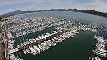
The Sausalito Yacht Harbor has slips for 600 vessels and is the southernmost harbor in Sausalito and is adjacent to the central downtown area.
Tourism

Due to its location at the north end of the Golden Gate Bridge, Sausalito receives a steady stream of visitors via the bridge (auto and bicycle traffic) and a ferry service from San Francisco. It retains one of the few ungated marinas in the Bay Area that attracts visitors.
Media
Sausalito has a local newspaper called the MarinScope,[30] owned by Vijay Mallya and edited by Jessica Mullins. Sausalito also has a small radio station founded by Jonathan Westerling, Radio Sausalito 1610 AM, which also serves as the city's Emergency Broadcasting System. The city's primary websites are the City's official site ci.Sausalito.ca.us,[31] the Chamber of Commerce sausalito.org,[32] a reference site oursausalito.com[33] and a guide for locals and visitors to the area Sausalito.com.[34]
Education
Sausalito is served by the Sausalito Marin City School District for primary school and the Tamalpais Union High School District for secondary school.[35] Residents have two public schools to choose from: the K-8 public school Bayside/Martin Luther King Academy in Marin City or the K-8 charter school Willow Creek Academy in Sausalito.[36] There are two private elementary schools that have been newly established in Sausalito, The K-8 Waldorf style New Village School, and PreK - 5 campus of the Lycée Français de San Francisco. High schoolers attend Tamalpais High School in Mill Valley.[35]
Parks and recreation

The public parks in Sausalito include Cazneau Playground, Cloud View Park, Dunphy Park, Gabrielson Park, Harrison Playground, Martin Luther King Park and Dog Park, Langendorf Park, Marinship Park, South View Park, Robin Sweeny Park, Tiffany Park, Vina del Mar Plaza, and Yee Tock Chee Park. The public beaches include Schoonmaker Beach, Swede's Beach and Tiffany Beach. Sausalito also has a municipal fishing pier and the Turney Street Boat Ramp. A club house/game room and an exercise room are located in the city hall.[37]
Houseboats
The Sausalito houseboat community consists of more than 400 houseboats of various shapes, sizes, and values, along the north end of town, approximately two miles from downtown.[38]

The roots of the Houseboat Community lie in the re-use of abandoned boats and material after the de-commissioning of the Marinship shipyards at the end of World War II. Many anchor-outs came to the area, which created problems with sanitation and other issues. After a series of tense confrontations in the 1970s and 1980s additional regulations were applied to the area and the great majority of boats were relocated to approved docks. Several are architect-designed pieces that have been featured in major magazines. The Gates Co-op Houseboat Community remains to this day, although recent action has required them to fit city-standards of sanitation and building codes. There is a new dock, approved by the city, being built, where all residents will have to relocate to avoid legal action.
The humming toadfish makes mating noises underwater, keeping some residents awake at nightl.[39][40][41][42][43][44]
Notable residents
The following is a list of notable residents of Sausalito, past and present.
Past
- Leon Adams, wine writer and author of Wines of America lived in Sausalito until his death.[45]
- Tim Lincecum, San Francisco Giants pitcher [46]
- Baby Face Nelson, American gangster of the 1920s[47]
- Sterling Hayden, American film actor and sailor.
- Otis Redding, musician, wrote "Dock of the Bay" while staying on a houseboat at Waldo Point in Sausalito in 1967.[48]
- Sally Stanford, former Sausalito City Council member and mayor, founder of the restaurant Valhalla, ran a well-known brothel at 1144 Pine Street in San Francisco.[49]
- Alan Watts, 20th century philosopher.[50] The Sausalito Library owns a permanent collection of all available audio cassettes of Watts’ spoken words[51]
Present-day

- Joanie Greggains KGO radio host [52]
- Vijay Mallya, Indian liquor magnate[53]
- Neal Gottlieb, Ice Cream Entrepreneur and Survivor: Kaoh Rong contestant
- Chase Utley MLB Baseball Player
Industry


- Heath Ceramics, founded by mid-century modern ceramicist Edith Heath, has been operating in Sausalito since 1948.
- Antenna Audio has a branch in Sausalito.
- In addition to Marinship, which built ships during World War II, Sausalito has a long history of boatbuilding. These boatyards specialized in a variety of vessels, including fishing and other work boats, government-contract vessels and recreational yachts. Many boatyards came and went in Sausalito in the late 19th century and early 20th century, including G. Smith, Brixen and Manfrey, the California Launch Building Company, the Reliance Boat Company, Nunes Brothers (Manuel and Antonio), Atlantic Boatbuilding Plant, Crichton and Arques, Sausalito Shipbuilding, Madden and Lewis, Menotti Pasquinucci and Bob's Boatyard. After World War II, the best known yards are, or were, Spaulding Boatworks, Bob's Boatyard, Easom Boatworks, Sausalito Marine, Bayside Boatworks, Richardson Bay Boat, the Boatbuilders Co-op and Anderson's Boat Yard.[54]
- The Spaulding Boatworks was founded in 1951 by Myron Spaulding and has been in continuous operation since then. It is one of the last remaining wooden boat yards on the West Coast. Today, the Spaulding Wooden Boat Center is a working and living museum, with a mission to restore and return to active use significant, historic wooden sailing vessels; preserve and enhance its working boatyard; create a place where people can gather to use, enjoy, and learn about wooden boats; and educate others about wooden boat building skills, traditions and values.
- The American Distilling Company manufactured and distributed various brands of whiskey, including "Bourbon Supreme." The distillery was destroyed by fire in the early '60s; the site is now the location of "Whiskey Springs" condominiums.
- The Mason Distillery once made medicinal alcohol here.
- The Southern Pacific ferryboat Berkeley was docked in Sausalito for several years during the 1960s after being taken out of service. It was subsequently towed to San Diego where it was restored and is a tourist attraction.
- The bakery concern Pepperidge Farm, which markets The American Collection line of cookies named after various notable locales (Chesapeake, Nantucket, Tahoe), has given the name Sausalito to their milk chocolate/macadamia-nut combo. It is not manufactured in the city. As of 2011, the company maintains a registered trademark on the name Sausalito.[55]
Sausalito in fiction
- A section of the 1892 novel The Wrecker, by Robert Louis Stevenson and Lloyd Osborn is set in Sausalito.
- The opening of The Sea-Wolf by Jack London is set on a ferryboat travelling from Sausalito to San Francisco. It is believed that London stayed for a time in Sausalito while he was writing the novel.
- Scenes in the 1947 film The Lady from Shanghai, directed by Orson Welles, take place on the Sausalito waterfront.
- The 1949 film Impact, directed by Arthur Lubin, features downtown Sausalito in its opening scenes.
- In Jack Kerouac's On the Road, Sausalito is mentioned as "a little fishing village" and a joke is made about it being "filled with Italians."
- Many scenes in the 1965 film Dear Brigitte with James Stewart, Glynis Johns, Ed Wynn, Bill Mumy, and Fabian Forte were filmed on the Sausalito shores of Richardson Bay.
- The 1968 film Petulia has Richard Chamberlain fishing Julie Christie out of the water at the foot of Johnson Street. Potted trees and other shrubbery, situated as set decorations on the adjacent docks, were left in place after filming had ended.
- M*A*S*H fictional character B. J. Hunnicutt was portrayed as having completed his medical residency in Sausalito (an impossibility, as the town has never had a hospital). His peacetime address is in Mill Valley, the town adjacent to Sausalito. He also mentions several times going to "a nice restaurant in Sausalito with his wife, Peg".
- A scene from the 1972 movie, Play It Again, Sam, was shot using interiors of the Trident restaurant and exteriors of the Spinnaker restaurant in Sausalito. In the film, actors Woody Allen and Tony Roberts are seen entering the Spinnaker restaurant with the ferryboat Berkeley, then tied up in Sausalito with the retail emporium Trade Fair in the background. The scene then cuts to the interior of the Trident.
- In the 1978 comic farce mystery detective thriller Foul Play Gloria Mundy, played by Goldie Hawn comes under the protection, broadly speaking, of San Francisco detective Lt Tony Carlson played by Chevy Chase who happens to have an especially charming houseboat in Sausalito.
- In the 1978 novel The House of God, the intern Hooper hails from Sausalito.
- In Star Trek IV: The Voyage Home, the fictional Cetacean Institute is in Sausalito. Although several scenes took place there, no filming was done in Sausalito itself. The actual film location for the fictional institute was the Monterey Bay Aquarium in Monterey, California.
- Craig Thomas set the home of Alan Aubrey in Sausalito in his 1990 thriller The Last Raven.
- Albert Brooks' Mother (1996), employs the town as the setting for its story, which features several shots of Sausalito throughout.
- In David Fincher's 1997 film The Game, set in San Francisco, Nicholas Van Orton's (Michael Douglas) ex-wife lives in Sausalito.
- Sausalito is the English title of a 2000 Hong Kong film directed by Lau Wai Keung, starring Maggie Cheung.
- In the television series Star Trek: Enterprise, a Vulcan "compound" is based in Sausalito, although it is not depicted; Fort Baker, which borders Sausalito is shown, and has become the site of Starfleet Headquarters. In Rise of the Federation - Uncertain Logic, set in 2165, Admiral Jonathan Archer lives in a houseboat in Sausalito.
- In Sofia Coppola's 2003 film Lost in Translation, a Jazz Band called Sausalito performs at the Park Hyatt Bar.
- In the 2005 video game Grand Theft Auto: San Andreas, there is a town based on Sausalito, named Bayside.
- Judd Apatow's 2009 dramedy Funny People uses Sausalito as the backdrop for the film's third act where Leslie Mann and Eric Bana's characters live with their family.
- 2010 racing video game Blur featured a track ostensibly set in Sausalito, although the game track does not resemble the actual landscape.
- The 2012 ABC series Red Widow was based in Sausalito. However, it was actually filmed in Vancouver, British Columbia, Canada. The series' main stars were Radha Mitchell and Goran Visnjic.
Sausalito in music
Songs referring to Sausalito
- "Sausilito", a top ten hit for Netherlands duo Rosy & Andres in 1975
- "Sausalito", Dead Fish (band), Vitória, 2015
- "Head Like a Rock", Ian McNabb, 1994
- "Postcard", Roddy Frame, Seven Dials, 2014
- "Jack Kerouac", Brooke Fraser, Flags, 2010
- "Sausalito", George Duke, Duke, 2005
- "Sausalito (The Governor's Song)", Bobby Darin, 1969
- Sausalito Summernight, Diesel, 1980-1981 (#25 - Billboard, #1 in Canada)
- "Samba de Sausalito", Santana, Welcome, 1973 album
- "Mr. Don", The Disco Biscuits
- "Sausalito", Grover Washington, Jr., Grover Washington Live in Concert, 1977
- "Sausalito (is the Place to Go)", Ohio Express "Best of Ohio Express"
- "Sausalito", Conor Oberst, "Conor Oberst" 2008
- "One Way Ticket" by Mimi and Richard Farina in Celebrations for a Grey Day
- "Sausalito", Los Abatidos, Los Abatidos, 1999.
- "Let It Flow (Sausalito Calling)", Camelle Hinds, "Soul Degrees", 1996
- "Sausalito in the Summetime" Benita Hill [56]
- "Real Emotional Trash", Stephen Malkmus and the Jicks, Real Emotional Trash, 2008.
Albums recorded in Sausalito
- Prince recorded his first studio album, For You at the Record Plant
- Prince, Huey Lewis and the News, the Dave Matthews Band, Journey and Bob Marley recorded albums at the Record Plant in Sausalito.
- Raised on Radio, Journey at The Plant Studios
- The Real Thing, Faith No More
- Load, Reload, and Garage Inc, Metallica (at The Plant Studios)
- The drums on Breaking the Silence, Heathen (at Studio D)
- Rumours, Fleetwood Mac
- Ferro e cartone, Francesco Renga (at The Plant Studios)
- Live Lycanthropy by Bay Area Band Papa Wheelie was recorded at The Plant Studios.
- Talkin' Blues, Bob Marley & the Wailers
- The Fray by The Fray
- Apple by Mother Love Bone (1990)
See also
References
- ↑ "California Cities by Incorporation Date" (Word). California Association of Local Agency Formation Commissions. Retrieved August 25, 2014.
- ↑ "City Council". Sausalito, CA. Retrieved December 30, 2014.
- 1 2 "Statewide Database". UC Regents. Retrieved December 30, 2014.
- ↑ "California's 2nd Congressional District - Representatives & District Map". Civic Impulse, LLC. Retrieved March 8, 2013.
- ↑ "2010 Census U.S. Gazetteer Files – Places – California". United States Census Bureau.
- 1 2 3 "Sausalito". Geographic Names Information System. United States Geological Survey. Retrieved January 8, 2015.
- 1 2 "Sausalito (city) QuickFacts". United States Census Bureau. Retrieved February 9, 2015.
- 1 2 3 Durham, David L. (1998). California's Geographic Names: A Gazetteer of Historic and Modern Names of the State. Clovis, Calif.: Word Dancer Press. p. 699. ISBN 1-884995-14-4.
- ↑
- 1 2 Robert Ryal Miller, Captain Richardson, Mariner, Ranchero, and Founder of San Francisco Berkeley: La Loma Press, 1995 [Call number at SSU: Regional Room F869 .S353 R546] 1995
- ↑ Greg Lucas, Chronicle Sacramento Bureau (2006-06-15). ""Now, houseboats not really sunk: Assembly bill seeks to legalize mooring on public property", San Francisco ''Chronicle'', June 15, 2006". Sfgate.com. Retrieved 2012-06-25.
- ↑ Greg Lucas, Chronicle Sacramento Bureau (2006-06-15). "op. cit., San Francisco ''Chronicle'', June 15, 2006". Sfgate.com. Retrieved 2012-06-25.
- ↑ Average weather for Sausalito Weather Channel Retrieved 2012-12-22
- ↑ Peterson, Bonnie J. (1976). Dawn of the World: Coast Miwok Myths. ISBN 0-912908-04-1
- ↑ National Park Service. (2005). Cultural Landscape Report for Fort Baker, Golden Gate National Recreation Area.
- 1 2 Tracy, Jack. Sausalito Moments in Time: A Pictorial History of Sausalito 1850-1950. Sausalito:Windgate Press 1983. ISBN 0-915269-00-7
- ↑ http://webbie1.sfpl.org/multimedia/sfphotos/AAC-2256.jpg
- ↑ SF Chronicle, December 5, 2008, pp.A1,A20
- ↑ "Historic California Posts: Fort Barry". Militarymuseum.org. Retrieved 2012-06-25.
- ↑ Soils testing results for the Liberty Shipbuilding site, Sausalito California, EMI report 7291W2, City of Sausalito Community Development Department, November 1989
- ↑ ""The decision was an important victory in the fight to end segregation in the work place and the fight for civil rights for all workers regardless of color.", BlackPast.org, accessed April 29, 2010". Blackpast.org. Retrieved 2012-06-25.
- ↑ A Short History of Liveaboards on the Bay, Larry Clinton, Bay Crossings, August 2001.
- ↑ "California's 2nd Congressional District - Representatives & District Map". Civic Impulse, LLC. Retrieved March 1, 2013.
- ↑ "Members Assembly".
- ↑ "Annual Estimates of the Resident Population for Incorporated Places: April 1, 2010 to July 1, 2015". Retrieved July 2, 2016.
- ↑ "Census of Population and Housing". Census.gov. Retrieved June 4, 2015.
- ↑ "2010 Census Interactive Population Search: CA - Sausalito city". U.S. Census Bureau. Retrieved July 12, 2014.
- ↑ "American FactFinder". United States Census Bureau. Retrieved 2008-01-31.
- ↑ Sausalito-on-the-Waterfront Foundation. "Purposes". Articles of Incorporation, Section 2 May 29, 2009
- ↑ "Marinscope Newspapers > Front". Marinscope.com. Retrieved 2012-06-25.
- ↑ "City of Sausalito : Home". Ci.sausalito.ca.us. 2012-05-18. Retrieved 2012-06-25.
- ↑ "Visit Sausalito, CA | Sausalito Chamber of Commerce". Sausalito.org. 2012-05-11. Retrieved 2012-06-25.
- ↑ "Our Sausalito.com". Our Sausalito.com. Retrieved 2012-06-25.
- ↑ "Sausalito California Hotels, Restaurants, Real Estate, Shopping". Sausalito.com. Retrieved 2012-06-25.
- 1 2 "SCHOOLS in the Tamalpais Union High School District and communities served." Tamalpais Union High School District. Retrieved on April 1, 2010.
- ↑ "K-8 Comprehensive Education Program." School(Archive) Sausalito Marin City School District. Retrieved on February 3, 2013.
- ↑ "Parks & Facilities." City of Sausalito. Retrieved on February 4, 2013.
- ↑ Kristine M. Carber, Special to The Chronicle (2003-10-04). ""Floating Through Life, Sausalito houseboat community will show off its one-of-a-kind dwellings on Sunday" ''San Francisco Chronicle'', October 4, 2003". Sfgate.com. Retrieved 2012-06-25.
- ↑ Hum along with male plainfin midshipman fish. Morning Edition. National Public Radio. July 29, 2009.
- ↑ Bishop, K. Sausalito Journal; Voice of the turtle? No, toadfish love song. New York Times. June 26, 1989.
- ↑ Sounds of the Plainfin Midshipman. Underwater Sound from the RTC Pier. Underwater Acoustics Research Group. San Francisco State University.
- ↑ Perlman, D. Hormones fine-tune the humming toadfish: High levels of estrogen found in the most responsive females. San Francisco Chronicle. July 19, 2004.
- ↑ Toadfish's steamy love life is revealed / Singing fish sometimes let meek males join a ménage à trois San Francisco Chronicle
- ↑ The humming toadfish story
- ↑ Howard G. Goldberg (September 16, 1995). "Leon Adams, Wine Expert And Writer, 90". Obituaries. New York Times. Retrieved November 24, 2011.
- ↑ Lee, Henry K.; Wildermuth, John (October 7, 2011). "Lincecum trashed S.F. townhouse, suit claims". The San Francisco Chronicle.
- ↑ SF Chronicle, Dec.5, 2008, p.A20
- ↑ San Francisco Chronicle, February 4, 2009, p.E3
- ↑ "Profile of life history of Sally Stanford". Mistersf.com. Retrieved 2012-06-25.
- ↑ Charters, Ann (ed.). The Portable Beat Reader. Penguin Books. New York. 1992. ISBN 0-670-83885-3
- ↑ "City of Sausalito : Alan Watts Audio Cassette Collection". Ci.sausalito.ca.us. 2011-04-28. Retrieved 2012-06-25.
- ↑ "Joanie Greggains, Director of Fitness, Smart Now". ZoomInfo.com. Retrieved 2012-06-25.
- ↑ Fost, Dan (June 24, 2011). "Vijay Mallya is not your typical brewer / Owner of Mendocino Brewing Co. is a member of India's Parliament - and more". The San Francisco Chronicle.
- ↑ Sausalito Historical Society. Sausalito (Images of America). San Francisco: Arcadia Publishing, 2005. ISBN 0-7385-3036-0
- ↑ http://www.pepperidgefarm.com/ProductDetail.aspx?catID=723&prdID=112069
- ↑ "Sausalito in the Summertime: Benita Hill: MP3 Downloads". Amazon.com. Retrieved 2012-06-25.
Further reading
- Tracy, Jack. Sausalito Moments in Time: A Pictorial History of Sausalito 1850–1950. Sausalito:Windgate Press 1983. ISBN 0-915269-00-7.
- Sausalito Historical Society. Sausalito (Images of America). San Francisco: Arcadia Publishing, 2005. ISBN 0-7385-3036-0.
External links
- Official website
- Sausalito Chamber of Commerce
- Sausalito local newspaper
- Sausalito reference site
- Sausalito Historic Context Statement - Ver Planck Consulting
| Wikivoyage has a travel guide for Sausalito. |
| Wikimedia Commons has media related to Sausalito, California. |
| Bodies of water |
|  |
|---|---|---|
| Counties | ||
| Major cities | ||
| Cities and towns 100k–250k | ||
| Cities and towns 50k–99k | ||
| Cities and towns 25k-50k | ||
| Cities and towns 10k–25k |
| |
| Sub-regions | ||