Brentwood, California
| City of Brentwood | ||
|---|---|---|
| City | ||
|
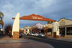
Gateway to downtown Brentwood | ||
| ||
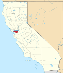
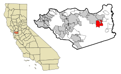 Location in Contra Costa County and the state of California | ||
 City of Brentwood Location in the United States | ||
| Coordinates: 37°55′55″N 121°41′45″W / 37.93194°N 121.69583°WCoordinates: 37°55′55″N 121°41′45″W / 37.93194°N 121.69583°W | ||
| Country | United States | |
| State | California | |
| County | Contra Costa | |
| Incorporated | January 21, 1948[1] | |
| Government | ||
| • Mayor | Robert Taylor[2] | |
| • State Senator | Steve Glazer (D)[3] | |
| • State Assembly | Jim Frazier (D)[4] | |
| • U. S. Congress | Jerry McNerney (D)[5] | |
| Area[6] | ||
| • Total | 14.805 sq mi (38.345 km2) | |
| • Land | 14.786 sq mi (38.295 km2) | |
| • Water | 0.019 sq mi (0.049 km2) 0.13% | |
| Elevation | 79 ft (24 m) | |
| Population (2010) | ||
| • Total | 51,481 | |
| • Density | 3,500/sq mi (1,300/km2) | |
| Time zone | PST (UTC-8) | |
| • Summer (DST) | PDT (UTC-7) | |
| ZIP code | 94513 | |
| Area code(s) | 925 | |
| FIPS code | 06-08142 | |
| GNIS feature IDs | 277479, 2409902 | |
| Website |
www | |
Brentwood is a city in Contra Costa County, California, United States. It is located in the East Bay region of the San Francisco Bay Area. The population is 51,481 as of 2010, an increase of 121 percent from 23,302 at the 2000 census.[7]
Brentwood began as a community in the late 19th century, and still is known throughout the Bay Area for its agricultural products, primarily its cherries, corn and peaches. Due to urban sprawl many of the old farms and orchards have been replaced by suburban developments since 1990. Brentwood is increasingly residential, with the rate of population growth in the triple digits during the 1990s and 69% from 2000 through 2005.
History
Brentwood was originally laid out on land donated from property owned by John Marsh, an East Contra Costa County pioneer who acquired Rancho Los Meganos, the land grant that Brentwood is built upon, in 1837 from Jose Noriega. Marsh was one of the wealthiest men in California and was instrumental in its becoming independent from Mexico and part of the United States. His letters extolling the potential for agriculture in California were published in newspapers throughout the East. They resulted in the first wagon trains to California. Marsh encouraged this, and allowed new arrivals to stay on his ranch until they could get settled. Rancho Los Meganos became the terminus of the California Trail.[8] Brentwood was named after Marsh's ancestral home, the town of Brentwood in the County of Essex, England.[9]
Brentwood's first post office was established in 1878.[10] The city incorporated in 1948.[10]
Balfour, Guthrie & Co., a British investment company, purchased the John Marsh ranch in 1910. The company invested heavily in other California agricultural properties as well. In 1910, it built the Brentwood Hotel at Oak Street and Brentwood Boulevard, across from the railroad station. This replaced an earlier hotel on the same site that had burned down in 1903. The hotel was razed in 1967, and replaced by a service station.[11]
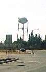
The Brentwood water tower perhaps symbolizes the city's transition from a rural farm community to a modern bedroom community. This landmark on Walnut Boulevard, across the street from the Brentwood Park and Ride lot, is the tallest structure in the city. It is no longer used for its original purpose, but now serves as a cell phone tower. City water is stored in large tanks atop hills outside the city.
The city is bordered on three sides by the Contra Costa County Agricultural Core which consists of 11,000 acres of preserved and still actively productive farm land.
During the 1990s, many types of retail stores were built along the Brentwood/Antioch border on Lone Tree Way, on both sides of SR 4 B, about 3.5 miles (5.6 km) from downtown Brentwood. The Streets of Brentwood, an outdoor lifestyle retail center, opened in Brentwood in 2008.
The city broke ground for a new civic center in November, 2009. The Mission-style architectural inspiration for City Hall, the main building, was the 1910 Brentwood Hotel. The $60 million project, completed in May 2012, includes the 58,000-square-foot City Hall and state-of-the-art City Council Chambers, a 32,000-square-foot community center, 280-space parking garage and redevelopment of the 2½-acre City Park. The community center also includes arts and crafts rooms as well as studios for dance classes and community exercise programs. The center received a Leadership in Energy and Environmental Design (LEED) Silver certification for amenities such as green roofs, bioswales, permeable paving and infiltration planters.[12] City departments began moving into the new facility in October 2011, and the former city hall was demolished during November 2011.
Geography
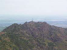
As is common with many East Bay towns in Contra Costa County, Mount Diablo is clearly seen from Brentwood. Brentwood is located on the alluvial plain of the Sacramento-San Joaquin Delta. In the picture shown at right, Brentwood lies center right and the city of Antioch lies center left. North Peak appears in the foreground between the two cities and largely hides the city of Oakley.
The East Bay Regional Park District is a special San Francisco Bay Area district operating in the East Bay counties of Alameda County and Contra Costa County. East Bay Regional Park District trails and parks are found in Brentwood.
Brentwood has a total area of 14.81 sq mi (38.4 km2), of which 14.79 sq mi (38.3 km2) is land and 0.02 sq mi (0.05 km2) or 0.13% is water. The landscape on the west is marked by rolling hills, non-native grasses, oak trees, fruit orchards, and vineyards, with a number of public golf courses.
Climate
Brentwood borders on the Mediterranean (Csa) and Semi-arid climates (Bsh). Like most of East Contra Costa County, Brentwood lies in the rain shadow of Mt. Diablo and receives less rainfall than many of its neighbors.[13] The wet season is generally October through April, though there may be a day or two of light rainfall in June or September. Summer heat is often moderated by the Delta Breeze, especially in the late afternoon, causing temperatures to cool rapidly.[14]
| Climate data for Brentwood, California | |||||||||||||
|---|---|---|---|---|---|---|---|---|---|---|---|---|---|
| Month | Jan | Feb | Mar | Apr | May | Jun | Jul | Aug | Sep | Oct | Nov | Dec | Year |
| Record high °F (°C) | 72 (22) |
76 (24) |
88 (31) |
94 (34) |
103 (39) |
117 (47) |
110 (43) |
109 (43) |
109 (43) |
102 (39) |
85 (29) |
75 (24) |
117 (47) |
| Average high °F (°C) | 54 (12) |
60 (16) |
66 (19) |
71 (22) |
79 (26) |
86 (30) |
92 (33) |
90 (32) |
86 (30) |
77 (25) |
64 (18) |
55 (13) |
73.3 (23) |
| Average low °F (°C) | 39 (4) |
43 (6) |
45 (7) |
48 (9) |
54 (12) |
58 (14) |
59 (15) |
59 (15) |
57 (14) |
52 (11) |
45 (7) |
39 (4) |
49.8 (9.8) |
| Record low °F (°C) | 20 (−7) |
25 (−4) |
27 (−3) |
28 (−2) |
35 (2) |
35 (2) |
41 (5) |
43 (6) |
41 (5) |
28 (−2) |
24 (−4) |
18 (−8) |
18 (−8) |
| Average precipitation inches (mm) | 2.66 (67.6) |
2.43 (61.7) |
2.08 (52.8) |
.78 (19.8) |
.43 (10.9) |
.09 (2.3) |
0 (0) |
.02 (0.5) |
.18 (4.6) |
.62 (15.7) |
1.60 (40.6) |
2.41 (61.2) |
13.3 (337.7) |
| Source: [15] | |||||||||||||
Government
The City of Brentwood operates under the City Manager form of government. Effective January 17, 2015, this position will be held by Gustavo "Gus" Vina. Vina was formerly city manager of Encinitas, California. Under policy direction of the City Council, the City Manager serves as the Chief Administrative Officer of the City; assumes full responsibility for planning, administering, directing, overseeing, and evaluating the activities and operations of all City departments. The following city departments report directly to the manager:
- Community Development
- Administrative Services
- Parks and Recreation
- Police
- Public Works / Engineering and Operations[16]
Education
Public schools
Brentwood's public education system has about 7 elementary, 3 middle, and 4 high schools, Independence High School, Liberty High School, Freedom High School and Heritage High School.
The city is served by the Brentwood Union School District, Knightsen School District and the Liberty Union High School District. The Brentwood Union School District runs on a modified traditional school calendar. The Brentwood Union School District has many schools designated as a California Distinguished School. Approximately five percent of California schools are awarded this honor.
Heritage High School includes a full range of Advanced Placement courses and the highest Academic Performance Index (California public schools)(API) score in the area, stellar performing arts programs, and championship athletic teams. Heritage is also a solar school. The 2.38 kW photovoltaic project installed at Heritage High School is designed to demonstrate the benefits and opportunities created by renewable energy technology and provide a powerful learning tool for both students and the community.
Los Medanos College operates a satellite facility at Sand Creek Road and Brentwood Boulevard in the city.[17]
Public libraries
The Brentwood branch of the Contra Costa County Library is located at 104 Oak Street, across from the Civic Center and City Park.[18] This building site served as a temporary facility, pending construction of a new library.
The Brentwood City Council approved the design for the new facility in September, 2016. The current library will be closed for two weeks, while its contents are moved to the new Community Center, adjacent to the new City Hall. Then the 104 Oak Street building and two other city-owned buildings at 118 and 120 Oak Street, are demolished. The three structures will be replaced by a 20,000 square feet (1,900 m2) building for the new library. The $12.2 million project is being funded by the remaining bond money that was originally raised to build the new City Hall, Community Center and parking garage. Bids will be let in January 2017, and the project is expected to be completed in 18 months.[19]
Demographics
| Historical population | |||
|---|---|---|---|
| Census | Pop. | %± | |
| 1950 | 1,729 | — | |
| 1960 | 2,186 | 26.4% | |
| 1970 | 2,649 | 21.2% | |
| 1980 | 4,434 | 67.4% | |
| 1990 | 7,563 | 70.6% | |
| 2000 | 23,302 | 208.1% | |
| 2010 | 51,481 | 120.9% | |
| Est. 2015 | 58,968 | [20] | 14.5% |
2010
The 2010 United States Census[22] reported that Brentwood had a population of 51,481. The population density was 3,477.3 people per square mile (1,342.6/km²). The racial makeup of Brentwood was 34,969 (67.9%) White, 3,389 (6.6%) African American, 333 (0.6%) Native American, 4,051 (7.9%) Asian, 202 (0.4%) Pacific Islander, 4,964 (9.6%) from other races, and 3,573 (6.9%) from two or more races. Hispanic or Latino of any race were 13,779 persons (26.8%).
The Census reported that 51,335 people (99.7% of the population) lived in households, 141 (0.3%) lived in non-institutionalized group quarters, and 5 (0%) were institutionalized.
There were 16,494 households, out of which 8,047 (48.8%) had children under the age of 18 living in them, 10,560 (64.0%) were opposite-sex married couples living together, 1,823 (11.1%) had a female householder with no husband present, 825 (5.0%) had a male householder with no wife present. There were 794 (4.8%) unmarried opposite-sex partnerships, and 141 (0.9%) same-sex married couples or partnerships. 2,616 households (15.9%) were made up of individuals and 1,355 (8.2%) had someone living alone who was 65 years of age or older. The average household size was 3.11. There were 13,208 families (80.1% of all households); the average family size was 3.47. The median income for a household in the town was $97,202.
The population was spread out with 16,058 people (31.2%) under the age of 18, 3,854 people (7.5%) aged 18 to 24, 13,991 people (27.2%) aged 25 to 44, 11,703 people (22.7%) aged 45 to 64, and 5,875 people (11.4%) who were 65 years of age or older. The median age was 35.6 years. For every 100 females there were 94.2 males. For every 100 females age 18 and over, there were 90.4 males.
There were 17,523 housing units at an average density of 1,183.6 per square mile (457.0/km²), of which 12,580 (76.3%) were owner-occupied, and 3,914 (23.7%) were occupied by renters. The homeowner vacancy rate was 2.7%; the rental vacancy rate was 6.0%. 38,410 people (74.6% of the population) lived in owner-occupied housing units and 12,925 people (25.1%) lived in rental housing units.
|
2000
As of the 2000 census, there were 23,265 residents.[24] The population density was 2,001.2/sqmi (774/km2). There were 7,788 housing units at an average density of 668.8/sqmi (259/km2). The racial makeup of the town was 75.38% White, 9.40% African American, 0.75% Native American, 6.99% Asian, 0.10% Pacific Islander, 5.96% from other races, and 1.43% from two or more races. Hispanic or Latino of any race were 10.34% of the population. There were 23,700 households out of which 45.8% had children under the age of 18 living with them, 69.2% were married couples living together, 7.0% had a female householder with no husband present, and 25.4% were non-families. 19.9% of all households were made up of individuals and 13.3% had someone living alone who was 65 years of age or older. The average household size was 2.58 and the average family size was 2.93. In the town the population was spread out with 22.9% under the age of 18, 3.2% from 18 to 24, 19.4% from 25 to 44, 33.4% from 45 to 64, and 21.0% who were 65 years of age or older. The median age was 48 years. For every 100 females there were 96.8 males. For every 100 females age 18 and over, there were 91.7 males. The median income for a household in the town was $87,068, and the median income for a family was $91,796.[25] Males had a median income of $58,059 versus $39,585 for females. The per capita income for the town was $33,621. About 5.4% of families and 9.3% of the population were below the poverty line, including 6.3% of those under age 18 and 3.5% of those age 65 or over.
Economy
Agriculture remains important to the local economy, but has declined in relative importance as the city has become more suburban. Local wineries including Bloomfield, Tamayo, and Hannah Nicole have gained in sales and prestige after winning numerous medals in recent years at the San Francisco Chronicle Wine Competition and the California State Fair. There is no heavy industry and only a small light industrial area in the northeastern part of the city. Brentwood underwent a strong economic boom from 2000 through 2008. Population expanded from 23,302 in 2000 to about 48,000 in 2006, a higher growth rate than other communities in the Bay Area. Some of the new neighborhoods were centered around two new golf courses, the Shadow Lakes Golf Club and the Deer Valley Golf Club, that were constructed to take advantage of the views of Mt. Diablo. The boom stalled in 2009, paralleling the economic crisis that affected all of California, but successful new home subdivisions, including a gated community (Carmel Estates), appeared again in 2010. Within an active adult community (Trilogy at the Vineyards), Club Los Meganos opened in 2010 with 34,000 square feet (3,200 m2) of athletic club, pool and cabanas, gourmet studio, spa, tennis courts, and events center. In 2013, Brentwood's economy displayed renewed economic vigor with substantial new activity in residential and commercial/retail construction. Sales offices of new home subdivisions commonly advertise new houses beginning in the $500Ks with the largest homes with many upgrades nearing $1M. The overall improvement in the Bay Area economy and anticipation for the 2015 completion of eBart and highway improvements in East Contra Costa County are playing a part in the revival of strong economic growth in Brentwood. One of the most exciting development opportunities in Brentwood is linked to the two Federal research facilities – Lawrence Livermore National Laboratory and Sandia National Laboratories – that are located 25 minutes south of Brentwood. Brentwood has established close relations with the national labs and is a member of i-GATE, which is a regional partnership designed to promote tech-oriented business growth connected with the labs.
Top employers
According to the City's 2009 Comprehensive Annual Financial Report,[26] the top employers in the city are:
| # | Employer | # of Employees |
|---|---|---|
| 1 | Brentwood Union School District | 500-600 |
| 2 | Liberty Union High School District | 400-500 |
| 3 | City of Brentwood | 200-300 |
| 4 | Precision Cabinets | 200-300 |
| 5 | Safeway | 100-200 |
| 6 | WinCo Foods | 100-200 |
| 7 | The Home Depot | 100-200 |
| 8 | Kohl's | 100-200 |
| 9 | Raley's | 100-200 |
| 10 | Best Buy | 50-100 |
Transportation
Highway
Public transportation is very limited, so the principal roads leading into the city are very congested with commuter traffic. No freeways served Brentwood directly, until February 2008, when the John Marsh Heritage Highway (also known as the California State Route 4 Bypass or Bypass Road, now California State Route 4) was built to connect the western side of Brentwood directly with Antioch. State Route 4 passes by the western edge of Brentwood. The freeway portion of SR 4 ends at the Sand Creek Road exit; SR 4 continues as a two-lane highway to its intersection with Marsh Creek Road and the end of Vasco Road, an unnumbered highway that is the principal route to Livermore, Interstate 580, and the Silicon Valley. To the southeast of Brentwood, County Route J4, known as the Byron Highway, connects to Tracy and the San Joaquin Valley.
Bus service
Local bus service is provided by Tri Delta Transit, a special purpose district providing public transportation for Eastern Contra Costa County. This district also operates express bus service to the Pittsburg/Bay Point and the Pleasanton/Dublin BART rail stations Monday through Friday, several a day, and only in the predominant commute direction.[27] Due to a route with a number of bus stops, it takes about one hour for the bus to reach Pittsburg/Bay Point BART from the Brentwood Park & Ride lot on Walnut Street.
Rail
A light rail Bay Area Rapid Transit expansion from Bay Point to Hillcrest Avenue, serving East Contra Costa County, known as eBart, is in progress and scheduled for completion in 2017.
There is no passenger rail service to Brentwood. The nearest Altamont Commuter Express train station is in Livermore. The nearest Amtrak station is in Antioch, CA.
There is a freight-only rail line that passes through Brentwood, which is owned by Union Pacific Railroad. However, the line has been inactive since the early 1990s. Union Pacific Railroad does have plans to reactivate this line sometime in the future.
Air
Commercial airports serving this area are:
- Oakland International Airport
- San Francisco International Airport
- San Jose International Airport
- Sacramento International Airport
- Stockton Metropolitan Airport
Other nearby airports serving private aircraft are:
Attractions and lifestyle
Brentwood was one of 212 cities designated by KaBOOM! as a Playful City USA for 2010 - one of only 23 such cities in California and only three in Northern California.[28] This is the seventh consecutive year that Brentwood has been listed. Each community selected demonstrated creative commitments to the cause of play and fitness. Brentwood was selected for a variety of reasons, including the fact that it offers the community its Wellness Policy, a community-wide aspirational goal which promotes physical activity and education as the benefits of living a healthy lifestyle. Brentwood has 68 parks and 17 smaller pocket parks within nearly 12 square miles (31 km2), and miles of jogging trails, to support healthy lifestyles.[29]
The visual and performing arts are well represented in Brentwood. The city is home to the Brentwood Art Society, which sponsors events such as the annual Art, Wine, and Jazz Festival, the Artists Open Studio Tour, open mic nights, and other gatherings and shows. The Art Society is also a supporter of the Brentwood Theater Company, which since 2010 has been producing Broadway musicals and musical reviews in venues around the city. In spring 2014, a major art gallery was opened in the Streets of Brentwood shopping center.[30]
Points of interest
- East Contra Costa Historical Society and Museum - east of Brentwood on Sellers Road.
- Los Vaqueros Reservoir (official website)
- Marsh Creek Regional Trail (official website)
- Marsh Creek State Park - currently not open to the public
- Round Valley Regional Preserve (official website)
- Vasco Caves Regional Preserve (official website)
- Sacramento-San Joaquin River Delta
- Brentwood Civic Center
- Streets of Brentwood shopping center
- John Marsh House - historic home, currently not open to the public; managed by the John Marsh Historic Trust.
Agriculture-related attractions
- The Art, Wine, and Jazz Festival is held each year in late August. A host of local vintners, wineries, and brewers participate, including: Hannah Nicole Vineyards, Bloomfield Vineyards, Tamayo Family Vineyards, J Doran Vineyards, Cline Cellars, and Black Diamond Brewery.
- Numerous local farms operate produce stands or offer "U-Pick" opportunities throughout Brentwood on the "Harvest Time" farm tour route.
- A farmers' market is held on First Street in downtown Brentwood on Saturday mornings from April through October.
- Hannah Nicole Vineyards includes a tasting room on Balfour Rd.
- Brentwood's CoCo County Wine Company offers local wines and imports along with a micro-brew beer selection in historic downtown Brentwood.
Notes
References
- ↑ "California Cities by Incorporation Date". California Association of Local Agency Formation Commissions. Archived from the original (Word) on November 3, 2014. Retrieved March 27, 2013.
- ↑ . City of Brentwood http://www.ci.brentwood.ca.us/citycouncil/members/members.cfm. Retrieved March 21, 2013. Missing or empty
|title=(help) - ↑ "Senators". State of California. Retrieved March 21, 2013.
- ↑ . State of California http://assembly.ca.gov/assemblymembers. Retrieved March 21, 2013. Missing or empty
|title=(help) - ↑ "California's 9th Congressional District - Representatives & District Map". Civic Impulse, LLC. Retrieved March 9, 2013.
- ↑ U.S. Census Archived 2012-01-24 at WebCite
- ↑ CensusViewer:Brentwood, California Population
- ↑ Lyman, George D. John Marsh, Pioneer: The Life Story of a Trail-blazer on Six Frontiers, pp. ix, 237-49, The Chautauqua Press, Chautauqua, New York, 1931.
- ↑ Gudde, Erwin; revised by William Bright (1998). California Place Names (4th ed.). Berkeley, CA: University of California Press. ISBN 0-520-21316-5.
- 1 2 Durham, David L. (1998). California's Geographic Names: A Gazetteer of Historic and Modern Names of the State. Clovis, Calif.: Word Dancer Press. p. 606. ISBN 1-884995-14-4.
- ↑ City of Brentwood Web site, "History and Timeline"
- ↑ City of Brentwood Web site
- ↑ http://www.co.contra-costa.ca.us/depart/cd/water/hcp/archive/downloads/wetland_report/Ch03_Hydrogeomorphic_Setting_10_14_04.pdf
- ↑ https://books.google.com/books?id=USbNknthNW0C&pg=PA32
- ↑ "Monthly Averages for Brentwood, CA (94513)". Weather.com. Retrieved May 17, 2012.
- ↑ City of Brentwood official website Official City of Brentwood Website
- ↑ Losmedanos.edu: Los Medanos College—Brentwood Center website; accessed August 4, 2010.
- ↑ "Brentwood Library." Contra Costa County Library. Retrieved on April 1, 2010.
- ↑ Szymanski, Kyle. "City council approves new library design with sign, shade." ThePress.Net. Accessed September 27, 2016.
- ↑ "Annual Estimates of the Resident Population for Incorporated Places: April 1, 2010 to July 1, 2015". Retrieved July 2, 2016.
- ↑ "Census of Population and Housing". Census.gov. Archived from the original on May 11, 2015. Retrieved June 4, 2015.
- ↑ "2010 Census Interactive Population Search: CA - Brentwood city". U.S. Census Bureau. Retrieved July 12, 2014.
- ↑ http://www.bayareacensus.ca.gov "Demographic Profile Bay Area Census" Check
|url=value (help). - ↑ "American FactFinder". United States Census Bureau. Archived from the original on 2013-09-11. Retrieved 2008-01-31.
- ↑ Benicia city, California - Fact Sheet - American FactFinder
- ↑ City of Brentwood CAFR
- ↑ Tri Delta Transit Web site
- ↑ "List of 2013 Playful City USA communities". Retrieved 26 February 2014.
- ↑ Mitchell, Eve, "Brentwood Again a 'Playful City.'" East County Times. May 23, 2014.
- ↑ King, Paula (18 February 2014). "New art gallery will bring visual, performing and literary arts together at Streets of Brentwood". Contra Costa Times. Retrieved 26 February 2014.
External links
| Wikimedia Commons has media related to Brentwood, California. |
| Wikivoyage has a travel guide for Brentwood, California. |
- City of Brentwood official website
- Everything Brentwood
- Brentwood Chamber of Commerce
- Brentwood Local News (Brentwood Press)
- Information: East Contra Costa County Historical Society Web site
- Brentwood Events EastCountyLive.com SPOTLIGHT
- Streets of Brentwood website
- Brentwood city, California - Fact Sheet - AmericanFactFinder
 |
Antioch | Oakley | Bethel Island Knightsen |
|
| Clayton, Walnut Creek | |
Discovery Bay | ||
| ||||
| | ||||
| Mount Diablo | Los Vaqueros Reservoir, Livermore | Byron |
| Bodies of water |
|  |
|---|---|---|
| Counties | ||
| Major cities | ||
| Cities and towns 100k–250k | ||
| Cities and towns 50k–99k | ||
| Cities and towns 25k-50k | ||
| Cities and towns 10k–25k |
| |
| Sub-regions | ||