Marconi, California
| Marconi | |
|---|---|
| Unincorporated community | |
|
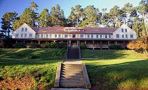
old hotel at the conference center in Marconi | |
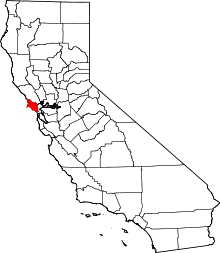
 Marconi  Marconi Location in California | |
| Coordinates: 38°08′38″N 122°52′42″W / 38.14389°N 122.87833°WCoordinates: 38°08′38″N 122°52′42″W / 38.14389°N 122.87833°W | |
| Country | United States |
| State | California |
| County | Marin County |
| Elevation[1] | 70 ft (21 m) |
| ZIP code | 94956 |
| Area codes | 415/628 |
| FIPS code | 06-45697 |
| GNIS feature ID | 1659056 |
Marconi (formerly called Fisherman's)[2] is an unincorporated community in Marin County, California.[1] It is located on the northeast shore of Tomales Bay, about seven miles (11 km) south-southeast of the village of Tomales,[2] at an elevation of about 70 feet (21 meters) above sea level.[1] Marconi is located in the area of the town of Marshall, California.
The inhabitants of old Native American settlement called "Fisherman's" later shipped seafood from here via railroad.[2] Then, in 1913, the Marconi Wireless Company bought this site to establish a transpacific wireless telegraph station.[2]
See also
References
| Bodies of water |
|  |
|---|---|---|
| Counties | ||
| Major cities | ||
| Cities and towns 100k–250k | ||
| Cities and towns 50k–99k | ||
| Cities and towns 25k-50k | ||
| Cities and towns 10k–25k |
| |
| Sub-regions | ||
This article is issued from Wikipedia - version of the 7/15/2016. The text is available under the Creative Commons Attribution/Share Alike but additional terms may apply for the media files.