Snodland
| Snodland | |
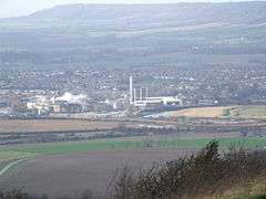 View over the Medway Gap from Blue Bell Hill with Snodland and the Horseshoe Reach meander of the River Medway with the paper mills in front, and the North Downs behind |
|
 Snodland |
|
| Population | 10,211 (2011 Census)[1] |
|---|---|
| OS grid reference | TQ699514 |
| District | Tonbridge and Malling |
| Shire county | Kent |
| Region | South East |
| Country | England |
| Sovereign state | United Kingdom |
| Post town | SNODLAND |
| Postcode district | ME6 |
| Dialling code | 01634 |
| Police | Kent |
| Fire | Kent |
| Ambulance | South East Coast |
| EU Parliament | South East England |
| UK Parliament | Chatham and Ayelsford |
Coordinates: 51°19′41″N 0°26′48″E / 51.328°N 0.4467°E
Snodland is a small town on the River Medway, located between Rochester and Maidstone in the English county of Kent. It is about 27 miles from central London and at the 2011 census had a population of 10,211 people.
History
"Snoddingland" is first mentioned in a charter of 838 in which King Egbert of Wessex gave "four ploughlands in the place called Snoddingland and Holanbeorge" (Holborough) to Beornmod, the Bishop of Rochester.[2] Since -ingland names are mostly derived from personal names, the name appears to refer to ‘cultivated land connected with Snodd’ or Snodda.[3] The Domesday Book refers to it as "Esnoiland".[4]
The first Roman advance in the conquest of Britain may have crossed the River Medway near Snodland, although there are contending locations. The supposed crossing place is marked by a memorial on the opposite side of the river from Snodland, close to Burham. Near this spot, a ferry later carried pilgrims bound for Canterbury along the Pilgrims' Way.
Bishop Gundulph, at the end of the 11th Century, built a palace at Halling that was used by his successors until the 16th century.
Lime working had been carried out at Snodland for centuries, but expanded dramatically in the 19th Century, as building boomed. The firm of Poynder and Medlicott began quarrying on the Snodland-Halling border in the early 19th century and the company was taken over by William Lee in 1846. Others followed and the last one was built in 1923 by W L H Roberts at Holborough. Lime for building Waterloo and other London bridges came from the area.
The paper-making industry came to Snodland around 1740, when the May family built a mill which the Hook family took over in 1854. New manufacturing techniques and the coming of the railway in the 1850s improved paper production from five to 70 tons a week. Snodland's population doubled between 1840 and 1857. After the Medway Valley railway was opened on 18 June 1856, the village trebled in size between 1861 and 1881. The parish boundary was re-aligned in 1898 and again in 1988 to reflect the growth of Snodland, both changes absorbed areas of Birling Parish, known locally as "Lower Birling".
Snodland is now under a 10-year development plan by Tonbridge and Malling Borough Council to redevelop and expand the Holborough part of Snodland. In 2005 Berkeley Homes began the construction of around 1,200 houses on the former Holborough Quarry.[5]
Government
Fifteen members sit on Snodland Town Council.[6] Snodland East Ward elects two councillors and Snodland West, three councillors, on Tonbridge and Malling Borough Council. In the 2011 election the latter elected three Conservative councillors and the former one Conservative and one Labour. Sarah Hohler is the town's member on Kent County Council and the town falls in the Chatham and Aylesford constituency, represented at Westminster by Conservative Tracey Crouch.
Geography
The town is wedged between the North Downs to the west and the river Medway to the east. Leybourne Lakes Country Park was created from disused gravel pits to the south that have been flooded and landscaped to make fishing and wildlife lakes;[7] across the river is the Burham Marsh nature reserve, a tidal reed bed.
Demography
At the 2011 census Snodland had a population of 10,211 people.[1]
Economy
Since 1903, Snodland has been the home of the Mid Kent Water Company. Mid Kent Water bought South East Water in October 2006, although regulatory issues dragged on until 2007.[8] The company adopted the name South East Water, whilst retaining the headquarters facilities in Rocfort Road. The company supplies 2.1 million customers in Kent, Sussex, Surrey, Hampshire and Berkshire - over 565 million litres of drinking water per day.
Culture and community
Since 1986, Snodland has been twinned with Moyeuvre-Grande, a town of similar size, located near Metz in North East France. The towns planned to celebrate the thirtieth anniversary of the partnership in May 2016.[9]
Snodland has two pubs, The Freemasons Arms and The Monks Head, and two Working men's clubs, Snodland WMC and Ham Hill WMC.
Landmarks
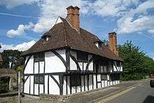
The Roman villa in Church Field has survived quite well and has been partially excavated.[10] Aside from the churches (see below), Woodlands Farmhouse on Constitution Hill is a Grade II* listed building dating to the early-mid 15th century.[11] The Mulberry Cottages on the High Street were originally a classical Wealden hall house dating to c1450;[12] there's another hall house at 72 Holborough Rd.[13] There are a number of more recent listed structures, perhaps the most unusual is a mock ruin, built c1850 to the south of the water company headquarters on the High St.[14]
Transport
The town is situated on the A228 road connecting the Medway Towns with Tonbridge. The M20 motorway junction 4 is 2 miles south of the town allowing good access to London and the Channel Ports. The Snodland by-pass takes heavy commercial traffic away from the town centre (an area commonly referred to as "the village" by residents). The Medway Valley Line between Strood and Maidstone passes through Snodland. The railway station opened with the extension of the North Kent Line from Strood to Maidstone (SER) on 18 June 1856.[15] There are peak time services via HS1 direct to St Pancras, otherwise for London passengers change at Strood or Maidstone Barracks/Maidstone East.
Education
The Holmesdale School is a Foundation school formerly known as Holmesdale Technology College. It still specialises in technology and is linked to The Malling School in The Malling Holmesdale Federation Trust.[16]
Religious sites
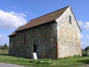
The town continues to support two active Anglican churches within the Archdeaconry of Rochester, but Roman Catholic, Methodist, United Reformed and Swedenborgian churches have all closed since the 1970s.[17] The parish church of All Saints dates to the 12th century with many additions since then.[18] The population growth in the 19th century led to the requirement for a new church in the south of the town, Christ Church which was designed by Percy Monkton in Early English Gothic Revival style. St Benedict's Church, Paddlesworth is a Norman church on the Pilgrim's Way about a mile west of the town. It dates from the early 12th century but has spent much of its life as a farm building and is currently in the care of the Churches Conservation Trust.[19]
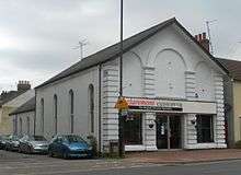
There is a Kingdom Hall on Church Field, used by local Jehovah's Witnesses. In the late 1940s the defunct Grand Picture Palace cinema on Holborough Road was converted into the Catholic Church of St. Thomas of Canterbury, but it was closed in 2007 and redeveloped.[20] A Primitive Methodist Chapel on Chapel Rd closed in 1976 and is now a car showroom. The Swenborgian Church of the New Jerusalem on the High St[21] was used until the 1980s but is now a private house. The United Church on the High St closed in 2011 after becoming structurally unsound. The cemetery opened in 1896 with the house and chapel being designed by Hubert Bensted of Maidstone.[22]
Sport
The Snodland Sports Association was set up in 2008. The 2012-13 season saw the merger of all the senior and junior football clubs in the town. As of 2016-17, Snodland Town F.C. competes in the Southern Counties East Football League, Division One. The other 13 teams include Snodland Town Reserves FC, Snodland Town Sunday FC and Snodland Town Nomads FC.[23]
Snodland Community Cricket Club who play at Rectory Meadow just off Rocfort Road car park. The Snodland Chess Club, established in 2003, use the Cricket Pavilion as their playing venue. The chess club have been national champions in two sections of the National Chess Club Championship.
Notable people
The postal pioneer Thomas Fletcher Waghorn[24] (1800–50), shortened the mail route to India from three months to between 35 and 45 days by going through the Egyptian desert. He is buried in the churchyard.
The white reggae singer Judge Dread (real name Alex Hughes, 1945–98) lived in Snodland. Alex Hughes Close is now named after him. Several Judge Dread songs refer to Snodland, such as "Belle of Snodland Town" and "Last Tango in Snodland".
Cultural references
Samuel Beckett referred to the town in his short play Play of 1963. It is believed that Beckett found Snodland while examining a local map of the area whilst staying in Kent.
"Before I could do anything he disappeared. That meant she had won. That slut! I couldn't credit it. I lay stricken for weeks. Then I drove over to her place. It was all bolted and barred. All grey with frozen dew. On the way back by Ash and Snodland"[25]
The British jazz/rock band Soft Machine included a track titled Snodland on their 1973 album Seven.
See also
- Dode, Kent - an extinct village in the hills above Snodland that was wiped out by the Black Death
References
- 1 2 "Civil Parish population 2011". Neighbourhood Statististics. Office for National Statistics. Retrieved 24 September 2016.
- ↑ "Saxons". Snodland Historical Society. Retrieved 2016-10-11.
- ↑ "History of Snodland". Kent Past. 2010. Retrieved 2016-10-11.
- ↑ Hasted, Edward (1798). "Parishes: Snodland". The History and Topographical Survey of the County of Kent: Volume 4. Canterbury: British History Online. pp. 463–470. Retrieved 2016-10-11.
- ↑ "7 Origins and Development of Snodland" (PDF). Tonbridge and Malling Borough Council. Retrieved 2016-10-11.
- ↑ "Councillors". Snodland Town Council. 2013. Retrieved 2016-10-11.
- ↑ "Leybourne Lakes Country Park - Bird monitoring 2003". Kent Ornithological Society. Retrieved 2016-10-11.
- ↑ "Merger of South East and Mid Kent Water brought benefits for customers". Utility Week. 21/July/2009. Retrieved 2016-10-11. Check date values in:
|date=(help) - ↑ "Moyeuvre-Grande : trente ans de jumelage avec Snodland". Le Républicain Lorrain (in French). 19 March 2016. Retrieved 2016-10-11.
- ↑ "Roman villa 200m north of church". Historic England. 11 Oct 2016. Retrieved 2016-10-11.
- ↑ "Woodlands Farmhouse". Historic England. 11 Oct 2016. Retrieved 2016-10-11.
- ↑ "Mulberry Cottages". Historic England. 11 Oct 2016. Retrieved 2016-10-11.
- ↑ "72, Holborough Road". Historic England. 11 Oct 2016. Retrieved 2016-10-11.
- ↑ "Grotto 15 yards south of Mid Kent Water company headquarters". Historic England. 11 Oct 2016. Retrieved 2016-10-11.
- ↑ "Snodland". Kent Rail. Retrieved 2016-10-11.
- ↑ "Welcome to theMalling Holmesdale Federation". Malling Holmesdale Federation. Retrieved 2016-10-11.
- ↑ Homan, Roger (1984). The Victorian Churches of Kent. Chichester: Phillimore & Co. p. 90. ISBN 0-85033-466-7.
- ↑ "Church Of All Saints". Historic England. 11 Oct 2016. Retrieved 2016-10-11.
- ↑ "Church Of St Benedict". Historic England. 11 Oct 2016. Retrieved 2016-10-11.
- ↑ "Queens Cinema". Cinema Treasures LLC. Retrieved 2016-10-11.
- ↑ "Church of the New Jerusalem". Historic England. 11 Oct 2016. Retrieved 2016-10-11.
- ↑ "Community Trails in the Medway Gap - Snodland" (pdf). Kent Downs AONB Unit. Retrieved 2016-10-11.
- ↑ "History". Snodland Town FC. Retrieved 2016-10-11.
- ↑ Great Britain House of Commons (1835). Journals of the House of Commons, Volume 90. H.M. Stationery Office. p. 482.
- ↑ Beckett, Samuel (2012). The Complete Dramatic Works of Samuel Beckett. Faber & Faber. p. 295. ISBN 9780571300198.
Further reading
- "A village sacrificed to industry", by Stephen Rayner, Memories page, Medway News, August, 2003.
External links
| Wikimedia Commons has media related to Snodland. |
- Snodland Town Council
- Snodland Historical Society have far more detail on the town's history
- Kent Rail - history of the railway in Snodland
Kent Portal | |
| Unitary authorities | |
| Boroughs or districts | |
| Major settlements |
|
| Rivers | See: Rivers of Kent |
| Topics | |