Kilby
| Kilby | |
 The village street |
|
 Kilby |
|
| Population | 270 (2011) |
|---|---|
| OS grid reference | SP 61978 95424 |
| – London | 100.1 mi (161.1 km) SE |
| Civil parish | Kilby |
| District | Blaby |
| Shire county | Leicestershire |
| Region | East Midlands |
| Country | England |
| Sovereign state | United Kingdom |
| Post town | WIGSTON |
| Postcode district | LE18 |
| Dialling code | 0116 |
| Police | Leicestershire |
| Fire | Leicestershire |
| Ambulance | East Midlands |
| EU Parliament | East Midlands |
| UK Parliament | South Leicestershire |
|
|
Coordinates: 52°33′11″N 1°05′14″W / 52.553139°N 1.0873400°W
Kilby is a village and civil parish in the Blaby district of Leicestershire, England.[1] It is the easternmost village in the district, and is 6 miles south east of Leicester.[2] Nearby places are Fleckney, Arnesby, Wistow and Kilby Bridge.
In the 1870s Kilby was described as "KILBY, a parish, with a village, in Blaby district, Leicestershire; on a branch of the river Soar, and on the Union canal, 2 miles SSE of Wigston railway station, and 6½ SSE of Leicester. Post town, Wigston, under Leicester. Acres, 1,060. Real property, £2,200.Population, 362. Houses, 95."[3]
History
Kilby has had the origins of its name possibly traced back to a Scandinavian form of Old English, being translated to 'children's farm/settlement.' [4] Kilby was mentioned in the Domesday book where it was said to have been originally formed around the parish Church of St. Mary Magdalene. In the Domesday book of 1068 Kilby or Cilebi, as it was spelt, resided in a district called 'Guthlaxton Wapentake' under the ownership of Oger the Breton who was recorded as Tennant-in-chief.[5] Kilby was recorded as having "28 households, containing 9 villagers, 7 smallholders, 2 slaves and 10 freemen." Kilby was also reported as having a Meadow consisting of 12 acres and 1 mill. Prior to the Domesday book the Lord of Kilby was recorded as Eur who resided as Lord during 1066.[6]

The parish Church is now located around a quarter of a mile away from the centre of modern-day Kilby.[7] The original parish Church finished construction in 1220, however this was replaced by the present day parish Church which was consecrated in 1858.[8] Population data for Kilby is available dating back to 1811 which at the time had a total population of 242. This figure is close to the 2011 census report of 270 inhabitants. Kilby reached its peak population, as dictated by census records, in 1831 with 434 inhabitants living in the village. This figure then significantly dropped to 291 in the 1881 census. The population of Kilby has remained has remained fairly consistent from 1881 to 2011.[9] Kilby contains a number of listed buildings such as the Bakehouse, Dog and Gun Public House and Kilby Lodge.[10] Many of the listed buildings date back to at least the 17th century.[11]
Boundary changes
The boundaries of the parish of Kilby were enlarged in April 1936 when the parish extended to include Foston after the closing of Foston Civil parish. This caused the parish boundaries of Kilby to increase from 1,068 acres to 2,401 acres, an increase of 1,333 acres.[12] To this day the parish of Kilby still includes Foston.
During the 19th century it is recorded that Kilby became an independent parish, having been previously in union with Newton Harcourt and Fleckney. It is thought that they had formed the ancient parish sometime in the 13th century.[13] Another boundary change occurred within Kilby during the First World War. This happened due to Lord Cottesloe of Wigston selling 50 acres of smallholdings to Leicestershire County Council, which were in turn given to ex-servicemen from Kilby who had fought in the First World War.[14]
Occupational statistics

Industrial occupational statistics for Kilby are available within the 1881 census. These statistics show that the main employment sector for workers in Kilby in 1881 was agriculture with 30.1% of the population involved. The industrial statistics also show that there was no significant divide in the amount of men and women employed in occupational sectors. Male workers made up 50.9% of the total amount of workers while women consisted of 49.1%.[15] However, there was a significant divide in the amount of men and women employed in the agricultural occupational sector. Within the agricultural workforce 97.87% of the workers were male while 2.13% of the workers were female.[16]
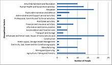
Modern day Kilby has seen a shift in the distribution of those involved in occupational employment as compared to the 1881 census report. The 2011 census statistics showed that the most popular occupational employment sector in Kilby was the wholesale and retail trade and the repair of motor vehicles and motorcycles with 15.9% of the working population involved.[17] This has changed from the 1881 census statistic of agriculture being the most prominent form of employment in Kilby with 30.1% of the working population being engaged in agriculture.[18] Whereas in modern day Kilby only 9.7% of the population is employed in agriculture,a difference of 20.4%.[19] The agricultural occupational sector began to nationally decline in the first half of the 20th century due to the industrialisation and mechanisation of agriculture. The agricultural sector was replaced by service industries as the major employment sector across England.[20] This national trend can be seen within the industrial statistics available for Kilby where the prominent employment sector in 2011 was a service industry.[21] The total number of persons employed in occupational sectors has decreased between 1881 and 2011. In 1881 the total number of people in eployment was 152.[22] This is greater than the 144 persons in eployment sectors in Kilby in 2011.[23] In 2011 the working population was smaller than 1881 even though the overall population of Kilby was greater than 1881. This can be attributed to children leaving school at a younger age in the 19th century to go to work, as opposed to the 21st century.[24]
Present day
Kilby has only one pub called the Dog & Gun, An Anglican Primary School and a Parish Church. There is also a park for the residents of Kilby. The park has a small football field, swings, a roundabout, climbing obstacles and a picnic table. There is a public bus service that runs at hourly intervals that connects with Kibworth Beauchamp or directly to Charles Street, Leicester. There is also a small elderly community. Kilby is located near the River Sense. Kilby had a population of 270 according to the 2011 census.[25]
Public transport in Kilby is currently served by the Arriva bus company that runs a service beginning in Leicester and running through Wigston Magna, Wigston Meadows, Wigston Harcourt, Kilby, Fleckney and then finishing at Kibworth Beauchamp.[26]
Education
Kilby contains one school called Kilby St Mary's Church of England Primary school which educates children from age 4 to age 11. The school came into existence in the 1850s which is currently a listed building.[27] As of September 2011 the current headteacher of the primary school is Ms Phillipa Denny.[28] Secondary education pupils in Kilby have to travel to nearby Wigston for schooling. The two closest secondary schools to Kilby are Wigston Birkett House Community Special School and The Beauchamp College. These schools are located 2.3 and 2.4 miles away from the village respectively.[29]
Places of interest
Kilby Wood is a woodland comprising 12.5 acres located to the South of Kilby. The woodland is continuing its growth with a 30-year lease being given by Leicestershire County Council. Villagers from Kilby have helped expand the woodland by sponsoring trees in memory of loved ones.[30]
Foston
The parish includes the deserted village of Foston to its west at grid reference SP 606 951 of which only the church and a farm remain. In the 1870s Foston was recorded as having six houses and 27 residents.[31]
References
- ↑ "Parish and Town Councils". Blaby District Council. Retrieved 16 April 2014.
- ↑ "Kilby Church St Mary Magdalene". Leicestershire Churches. Retrieved 16 April 2014.
- ↑ Wilson, John Marius (1870–1872). Imperial Gazetteer of England and Wales. Edinburgh: A. Fullarton & Co. Retrieved 5 February 2014.
- ↑ "Key to English Place-names". University of Nottingham. Retrieved 6 February 2014.
- ↑ "Kilby History". GENUKI. Retrieved 16 February 2014.
- ↑ "Place:Kilby". Open Domesday. Retrieved 16 February 2014.
- ↑ "The History of Kilby". Leicestershire Villages. Retrieved 6 February 2014.
- ↑ "Kilby". GENUKI. Retrieved 16 February 2014.
- ↑ "Population Statistics". A Vision of Britain Through Time. Retrieved 18 February 2014.
- ↑ "Search results of Listed Buildings: Kilby". English Heritage. Retrieved 23 February 2014.
- ↑ "Listed Buildings". Leicestershire Villages. Retrieved 23 February 2014.
- ↑ "Politics and Governance". GENUKI. Retrieved 18 February 2014.
- ↑ "Wistow-Church". British History Online. Retrieved 8 March 2014.
- ↑ "Effects of 2 World Wars". Leicestershire Villages. Retrieved 23 February 2014.
- ↑ "Industry Statistics". A Vision of Britain Through Time. Retrieved 23 February 2014.
- ↑ "Occupational Statistics: Kilby". A Vision of Britain Through Time. Retrieved 26 March 2014.
- ↑ "Kilby, Industry 2011". Office for National Statistics. Retrieved 25 February 2014.
- ↑ "Industry Statistics". A Vision of Britain Through Time. Retrieved 23 February 2014.
- ↑ "2011 Census:Quick Statistics". Office for National Statistics. Retrieved 25 February 2014.
- ↑ "170 years of Industrial Changes across England and Wales". Office for National Statistics. Retrieved 26 March 2014.
- ↑ "Kilby, Industry 2011". Office for National Statistics. Retrieved 26 March 2014.
- ↑ "Industrial Statistics: Kilby". A Vision of Britain through Time. Retrieved 26 March 2014.
- ↑ "Kilby, Industry 2011". Office for National Statistics. Retrieved 26 March 2014.
- ↑ "Education in England: A Brief History". Education England. Retrieved 26 March 2014.
- ↑ "Kilby: Key Figures for 2011 Census: Key Statistics". Neighbourhood Statistics. Office for National Statistics. Retrieved 5 February 2014.
- ↑ "Service Information". Arriva. Retrieved 23 February 2015.
- ↑ "Kilby Church of England School". Leicestershire Villages. Retrieved 25 February 2014.
- ↑ "Staff Responsibilities". Kilby's St Mary Church of England Primary School. Retrieved 25 February 2014.
- ↑ "School Finder". RM Education. Retrieved 25 February 2014.
- ↑ "Kilby Wood". Leicestershire Villages. Retrieved 8 March 2014.
- ↑ GB Historical GIS / University of Portsmouth, History of Foston, in Blaby and Leicestershire | Map and description, A Vision of Britain through Time. Date accessed: 10 March 2014
External links
![]() Media related to Kilby at Wikimedia Commons
Media related to Kilby at Wikimedia Commons
Towns and villages of Blaby District | ||
|---|---|---|
| Towns |  | |
| Large villages | ||
| Small villages | ||
| Hamlets | ||