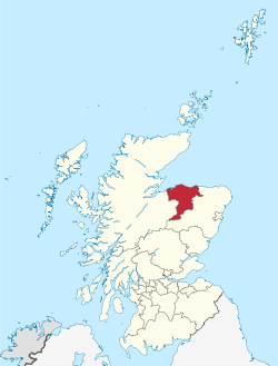
Moray
| Moray Moireibh | ||
|---|---|---|
 | ||
| ||
| Coordinates: 57°25′N 3°15′W / 57.417°N 3.250°WCoordinates: 57°25′N 3°15′W / 57.417°N 3.250°W | ||
| Admin HQ |
High Street Elgin Moray IV30 1BX | |
| Government | ||
| • Body | The Moray Council | |
| • Control | Ind + Con (council NOC) | |
| • MPs | Angus Robertson for Moray | |
| • MSPs | ||
| Area | ||
| • Total | 864 sq mi (2,238 km2) | |
| Area rank | Ranked 8th | |
| Population (2010 est.) | ||
| • Total | 93,000 | |
| • Rank | Ranked 26th | |
| • Density | 100/sq mi (39/km2) | |
| ONS code | 00QX | |
| ISO 3166 code | GB-MRY | |
| Website |
www | |
Moray (/ˈmʌri/ MUH-ray; Scottish Gaelic: Moireibh or Moireabh, Latin: Moravia, Old Norse: Mýræfi) is one of the 32 Local Government council areas of Scotland. It lies in the north-east of the country, with coastline on the Moray Firth, and borders the council areas of Aberdeenshire and Highland.
Between 1975 and 1996 Moray, with similar boundaries, was a district of the then Grampian Region.
Etymology
The name, first attested around 970 as Moreb, and in Latinised form by 1124 as Morauia, derives from the earlier Celtic forms *mori 'sea' and *treb 'settlement'.[1]
Politics
The Moray council area was created in 1996, under the Local Government etc. (Scotland) Act 1994, with the boundaries of the former Moray district of the two-tier Grampian Region, which replaced the old county of Moray in 1974, though it had different boundaries.
In the Scottish independence referendum on 18 September 2014 Moray voted "no":
- No: 36,935 (57.6%)
- Yes: 27,232 (42.4%)
- Turnout: 85.4%
In the European Union membership referendum on 23 June 2016 Moray voted "remain":
- Leave: 23,992 (49.9%)
- Remain: 24,114 (50.1%)
- Turnout: 67.4%
This was the biggest percentage for "Leave" out of all the Scottish councils and the narrowest margin of victory for either side anywhere in the UK in this referendum.
Parliamentary constituencies
In the House of Commons of the Parliament of the United Kingdom of Great Britain and Northern Ireland (Westminster), the council area is covered the Moray (Westminster) constituency.
In the Scottish Parliament (Holyrood), most of the council area is covered by the Moray (Holyrood) constituency, which is in the Highlands and Islands electoral region. The Keith area (most of the Keith and Cullen ward), however, is within the Banffshire and Buchan Coast constituency, which is in the North East Scotland electoral region.
Towns and villages
- Aberlour
- Alves
- Archiestown
- Arradoul
- Auchenhalrig
- Bogmoor
- Broadley
- Buckie
- Burghead
- Clochan
- Craigellachie
- Cullen
- Cummingston
- Dallas
- Deskford
- Dipple
- Drybridge
- Dufftown
- Duffus
- Dyke
- Elgin
- Findhorn
- Findochty
- Fochabers
- Forres
- Fogwatt
- Garmouth
- Hopeman
- Ianstown
- Inchberry
- Keith
- Kingston
- Kinloss
- Lhanbryde
- Longmorn
- Lossiemouth
- Mill of Tynet
- Mosstodloch
- Nether Dallachy
- Newmill
- Ordiquish
- Portgordon
- Portknockie
- Rathven
- Rafford
- Rothes
- Rothiemay
- Spey Bay
- Tomintoul
- Unthank
- Upper Dallachy
- Urquhart
Education
There are 45 primary and eight secondary schools in Moray and the council currently has responsibility for educating more than 13,000 school pupils. The council's community learning and development team is also involved in arranging a wide range of classes and courses for adult learners. The council also currently operates 15 public libraries, all with free internet and e-mail access, and two mobile libraries which service users in more remote areas.
Moray is also home to the University of the Highlands and Islands affiliated Moray College, and to Gordonstoun independent boarding school and its accompanying preparatory school, Aberlour House.
Infrastructure
Moray Council is also responsible for the maintenance of 1,000 miles or road, 450 miles of footpath, 468 bridges, 16,000 street lights and 10,500 road signs.
As a housing authority, Moray Council manages just under 6,000 council properties and operates a council house waiting list. It also provides housing which has been specially designed, built or adapted to meet the requirements of certain groups such as the elderly and those with special needs. The council's development control section, which is part of the environmental services department, deals with thousands of planning applications every year from individuals and organisations seeking permission to erect buildings or adapt existing ones.
Environment

Approximately 50,000 tonnes of waste is collected from homes and commercial properties in Moray. Households in many communities benefit from a kerbside recycling service. There are over 60 recycling points located throughout Moray in addition to eight larger recycling centres.
Economy
Employment
The working population of Moray in 2003 was nearly 40,000 of which around 34,000 were employees and 6000 self-employed. Of this 34,000, 31% are employed in the public sector, compared with 27% for Scotland and 25% for the UK (the RAF personnel are not included in these figures). Only 18% of jobs are managerial or professional compared to 25% for Scotland.

Economic performance and development
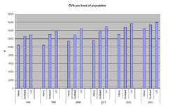
The gross value added (GVA)[2] in Moray was £1.26 billion, in 2003. This corresponds to an output of £14,500 per resident and was 6% below the average for Scotland and 12% below that of the UK.
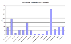
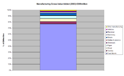
The diagrams show the strong reliance on the food and drink industry i.e. the distilling, canned food and biscuit manufacturing industries. The public sector is also very prominent. Of the total GVA of £1.26 billion, food and drink is responsible for 19% while 3% is the Scottish figure and 2% for the UK. Moray is responsible for 9% of the entire food and drink GVA of Scotland. Significant areas where Moray has a larger than average share of national markets are in tourism, forest products, textiles and specialized metal working. In contrast, however, Moray is significantly under-represented in the business services area at 15% of GVA while it is 19% for Scotland and 25% for the UK.
In March 2014 a tourism strategy was launched by the Moray Economic Partnership aimed at doubling the £95m industry over the next decade.[3] In June 2014 a website (morayspeyside.com) was launched under the auspices of the Moray Chamber of Commerce to support the strategy and provide a one-stop shop for visitors.[4][5]
Earnings
Compared to Scottish or British levels, average incomes in Moray are low. The average wage in 2003 was £286 per week, which was 12% below the Scottish average and 18% below the British (these statistics exclude the armed forces). These figures reflect the large amount of part-time employment, with fewer qualified workers and less managerial and professional jobs. 16% of residents out-commute, which is relatively high. Of these, two-thirds work in Aberdeen or Aberdeenshire, mainly in the oil and gas industry. These out-commuters earn significantly more than local workers.
Business base
In 2004, there were around 2,500 VAT registered businesses in Moray with 75% of businesses employing fewer than 5 people and about a half of firms with a turnover of less than £100,000. 60% of employees are employed in small firms compared to 48% for Scotland as a whole.
Moray's major companies export their products to other British regions and abroad and many of the smaller companies have direct involvement with neighbouring economies in Aberdeen, Aberdeenshire and Highland. Also, a large out-commuting workforce (estimated to be in excess of 5,000 people) derives its income from the neighbouring centres of Aberdeen and Inverness.

Note: 2003 and 2004 data at SCOTDAT was the most up-to-date, as of August 2006
Population
An inhabitant of the Moray, especially the historic Mormaer of Moray, is called Moravian.[6]
Unlike many other regions of Scotland, which are experiencing population decline, Moray's population is expected to grow modestly to around 91,000 by 2024. Its population at the 2011 census was 93,295.

Source: General Register Office for Scotland[7]
Language
The first records on language use in the area indicate that in 1705, most of Moray except for the coast was described as "Wholly Irish & Highland Countreys" and "Ye Irish Parishes in which both languages are spoken."[8] By 1822, Scottish Gaelic had weakened in the area, with only the far south of Moray reporting that, at best, 10% of the population were speaking Gaelic better than English.[8] Records towards the end of the 19th century improved and show that between 1881 and 1921 the percentage of Gaelic speakers in Moray fluctuated as shown in the following table:
| Year | Gaelic speakers (%) |
|---|---|
| 1881 | 2.63 |
| 1891 | 5.64 |
| 1901 | 4.48 |
| 1911 | 2.98 |
| 1921 | 2.08 |
| 1991[9] | 0.56 |
Since then, it has been consistently below 1%. It was largely replaced by Doric and latterly Scottish English.
See also
Notes
- ↑ David Mills, A Dictionary of British Place-Names, rev. edn (Oxford: Oxford University Press, 2011), p. 333.
- ↑ GVA = Gross Value Added is the term now used for total wealth created in the regional economy. Measured at basic prices, it is close to what was formerly known as Gross Domestic Product at factor cost.
- ↑ "Tourism strategy launched for Moray".
- ↑ https://www.pressandjournal.co.uk/fp/news/moray/268326/moray-tourism-website-launched/
- ↑ http://www.morayspeyside.com/us/
- ↑ "Famous Moravians".
- ↑ General Register Office for Scotland
- 1 2 Withers, C. Gaelic in Scotland 1698-1981 (1984) John Donald Publishers ISBN 0-85976-097-9
- ↑ "Welcome to Scotland's Census - Scotland Census 2011".
References
- A joint report HIE Moray and Moray Council, entitled "Moray 2020: Strategy for the Diversification of the Economy of Moray Following Restructuring of the RAF Bases at Kinloss and Lossiemouth", is available at both web sites.
External links
| Wikimedia Commons has media related to Moray. |
| Wikivoyage has a travel guide for Moray. |
- Moray Council
- Moray Speyside Tourism, the official tourism website for Moray
- Moray at DMOZ
- Undiscovered Speyside Community Web Site, a portal for all things Speyside
- Moray and Speyside info
Places in Moray | ||
|---|---|---|
|  | |