Eastport, California
| Eastport | |
|---|---|
| Unincorporated community | |
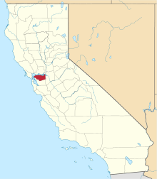
 Eastport Location in California | |
| Coordinates: 37°50′23″N 122°10′50″W / 37.83972°N 122.18056°WCoordinates: 37°50′23″N 122°10′50″W / 37.83972°N 122.18056°W[1] | |
| Country | United States |
| State | California |
| County | Contra Costa County |
| Elevation[1] | 840 ft (256 m) |
| GNIS ID[1][2] | 1658467 |
| FIPS code[1][2] | 06-21005 |
Eastport is a small unincorporated community in the Berkeley Hills, in southern Contra Costa County, California.[1]
Geography
It is located 2.5 miles (4.0 km) south of Orinda,[3] at an elevation of 840 feet (256 m).[1] It lies along Pinehurst Road between Oakland and Canyon, which is the closest settlement.
The ZIP Code is 94516. The community is inside area code 510.
History
Eastport is located at what was the eastern portal of the Sacramento Northern Railroad Berkeley Hills Tunnel (abandoned 1957), hence the name.
References
- 1 2 3 4 5 6 "Eastport (Contra Costa County, California)". Geographic Names Information System. United States Geological Survey. Retrieved May 10, 2014.
- 1 2 "FIPS55 Data: California". FIPS55 Data. United States Geological Survey. February 23, 2006. Archived from the original on June 18, 2006. Retrieved May 10, 2014. External link in
|work=(help) - ↑ Durham, David L. (1998). California's Geographic Names: A Gazetteer of Historic and Modern Names of the State. Clovis, Calif.: Word Dancer Press. p. 628. ISBN 1-884995-14-4.
| Bodies of water |
|  |
|---|---|---|
| Counties | ||
| Major cities | ||
| Cities and towns 100k–250k | ||
| Cities and towns 50k–99k | ||
| Cities and towns 25k-50k | ||
| Cities and towns 10k–25k |
| |
| Sub-regions | ||
This article is issued from Wikipedia - version of the 3/28/2016. The text is available under the Creative Commons Attribution/Share Alike but additional terms may apply for the media files.