Crockett, California
| Crockett | |
|---|---|
| Census-designated place | |
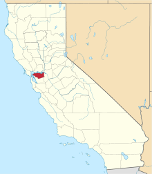
 Location in Contra Costa County and the state of California | |
 Crockett Location in the United States | |
| Coordinates: 38°03′09″N 122°12′47″W / 38.05250°N 122.21306°WCoordinates: 38°03′09″N 122°12′47″W / 38.05250°N 122.21306°W | |
| Country |
|
| State |
|
| County | Contra Costa |
| Government | |
| • State Senate | Bill Dodd (D)[1] |
| • State Assembly | Tim Grayson (D)[2] |
| • U. S. Congress | Mike Thompson (D)[3] |
| Area[4] | |
| • Total | 1.060 sq mi (2.746 km2) |
| • Land | 1.060 sq mi (2.746 km2) |
| • Water | 0 sq mi (0 km2) 0% |
| Elevation[5] | 128 ft (39 m) |
| Population (2010) | |
| • Total | 3,094 |
| • Density | 2,900/sq mi (1,100/km2) |
| Time zone | PST (UTC-8) |
| • Summer (DST) | PDT (UTC-7) |
| ZIP code | 94525 |
| Area code(s) | 510 |
| FIPS code | 06-17274 |
| GNIS feature IDs | 277495, 2407683 |
Crockett (formerly, Crockettville)[6] is a census-designated place (CDP) in Contra Costa County, California, United States. The population was 3,094 at the 2010 census. It is located 5 miles (8 km) west of Martinez and 5 miles (8 km) north of Richmond.[6]
Geography
According to the United States Census Bureau, the CDP has a total area of 1.1 square miles (2.8 km2), all of it land.
Crockett is located where the Carquinez Strait meets San Pablo Bay. The Carquinez Bridge, part of Interstate 80, links Crockett with the city of Vallejo to the north across the strait. To the east of Crockett along the strait are Port Costa and the city of Martinez. South of Crockett are the town of Rodeo and the city of Hercules. Farther southwest on I-80 are the cities of Richmond, Berkeley and Oakland; in the opposite direction, northeast, is the capital of California, Sacramento.
Climate
This region experiences warm (but not hot) and dry summers, with no average monthly temperatures above 71.6 °F. According to the Köppen Climate Classification system, Crockett has a warm-summer Mediterranean climate, abbreviated "Csb" on climate maps.[7]
History
Crockett is located on the Mexican land grant Rancho El Pinole made to Ygnacio Martinez, and is named after Joseph B. Crockett, a judge on the California Supreme Court.[6] The town started when Thomas Edwards Sr. bought 1,800 acres of land from Judge Crockett in 1866. Edwards built his home in 1867 and when other settlers arrived, he started the first general store in Crockett. Edwards' home still stands and is known as "The Old Homestead", a California Historical Landmark.[8] In 1906 an agricultural cooperative of Hawaiian sugar cane growers built a sugar factory in Crockett, eventually turning it into a company town for the C&H Sugar company.[6]
Crocketville post office was established in 1883, and the name was changed to Crockett later that year.[6]
Arts and Culture
The Bailey Art Museum
The Bailey Art Museum features the work of internationally acclaimed sculptor Clayton Bailey, a resident of nearby Port Costa.[9]
The 3200 square foot space brings together works from across the artist's five decades plus career featuring examples of Funk art, Nut art, ceramics, and metal sculpture (including robots and space guns), as well as pseudo-scientific curiosities by the artist's alter-ego Dr. Gladstone. The collection also includes watercolor drawings by Betty Bailey and a gift shop.[10]
Demographics
2010
The 2010 United States Census[11] reported that Crockett had a population of 3,094. The population density was 2,918.7 people per square mile (1,126.9/km²). The racial makeup of Crockett was 2,468 (79.8%) White, 146 (4.7%) African American, 31 (1.0%) Native American, 108 (3.5%) Asian, 24 (0.8%) Pacific Islander, 123 (4.0%) from other races, and 194 (6.3%) from two or more races. Hispanic or Latino of any race were 490 persons (15.8%).
The Census reported that 100% of the population lived in households.
There were 1,446 households, out of which 306 (21.2%) had children under the age of 18 living in them, 554 (38.3%) were opposite-sex married couples living together, 166 (11.5%) had a female householder with no husband present, 77 (5.3%) had a male householder with no wife present. There were 133 (9.2%) unmarried opposite-sex partnerships, and 22 (1.5%) same-sex married couples or partnerships. 482 households (33.3%) were made up of individuals and 158 (10.9%) had someone living alone who was 65 years of age or older. The average household size was 2.14. There were 797 families (55.1% of all households); the average family size was 2.69.
The population was spread out with 461 people (14.9%) under the age of 18, 214 people (6.9%) aged 18 to 24, 825 people (26.7%) aged 25 to 44, 1,131 people (36.6%) aged 45 to 64, and 463 people (15.0%) who were 65 years of age or older. The median age was 45.7 years. For every 100 females there were 95.9 males. For every 100 females age 18 and over, there were 95.6 males.
There were 1,649 housing units at an average density of 1,555.5 per square mile (600.6/km²), of which 808 (55.9%) were owner-occupied, and 638 (44.1%) were occupied by renters. The homeowner vacancy rate was 1.3%; the rental vacancy rate was 10.1%. 1,808 people (58.4% of the population) lived in owner-occupied housing units and 1,286 people (41.6%) lived in rental housing units.
2000
As of the census[12] of 2000, there were 3,194 people, 1,491 households, and 848 families residing in the CDP. The population density was 634.7 people per square mile (245.2/km²). There were 1,590 housing units at an average density of 315.9 per square mile (122.0/km²). The racial makeup of the CDP was 85.10% White, 3.13% Black or African American, 0.94% Native American, 2.60% Asian, 4.26% from other races, and 3.98% from two or more races. 11.62% of the population were Hispanic or Latino of any race.
There were 1,491 households out of which 21.9% had children under the age of 18 living with them, 40.1% were married couples living together, 11.3% had a female householder with no husband present, and 43.1% were non-families. 34.6% of all households were made up of individuals and 11.1% had someone living alone who was 65 years of age or older. The average household size was 2.14 and the average family size was 2.75.
In the CDP the population was spread out with 18.5% under the age of 18, 5.9% from 18 to 24, 30.6% from 25 to 44, 30.1% from 45 to 64, and 15.0% who were 65 years of age or older. The median age was 42 years. For every 100 females there were 96.2 males. For every 100 females age 18 and over, there were 93.7 males.
The median income for a household in the CDP was $48,574, and the median income for a family was $66,174. Males had a median income of $46,311 versus $31,204 for females. The per capita income for the CDP was $27,469. About 4.8% of families and 7.4% of the population were below the poverty line, including 12.1% of those under age 18 and 9.2% of those age 65 or over.
Economy
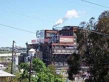
Crockett is home to the corporate headquarters of C&H Sugar, a subsidiary of American Sugar Refining.[13][14]
Education
Crockett is part of the John Swett Unified School District and is home to both Carquinez Middle School and John Swett High School.
The Crockett Library of the Contra Costa County Library is located in Crockett.[14][15]
Recreation
Crockett is bordered to the south and the east by two regional parks operated by the East Bay Regional Park District.
Crockett Hills Regional Park lies south of Crockett. The 1,939 acre park ranges in elevation from 150-800 feet, offering views of San Pablo Bay, the Delta, Mount Tamalpais, and Mount Diablo. Trails include a 4.5-mile segment of the Bay Area Ridge Trail. Crockett Hills is an excellent mountain biking park. [16][17]
Carquinez Strait Regional Shoreline comprises 1,415 acres of bluffs and shoreline along Carquinez Scenic Drive between the town of Crockett and the hillsides overlooking Martinez. [18]
The topography of Crockett Ranch Regional Park and the adjoining Carquinez Regional Shoreline consists of open, rolling grasslands, wooded ravines, eucalyptus-shaded meadows, and river shoreline. Multi-purpose trails provide access to canyon views and ridgetop vistas.
References
- ↑ "Senators". State of California. Retrieved March 29, 2013.
- ↑ "Members Assembly". State of California. Retrieved March 29, 2013.
- ↑ "California's 5th Congressional District - Representatives & District Map". Civic Impulse, LLC. Retrieved March 9, 2013.
- ↑ "2010 Census U.S. Gazetteer Files – Places – California". United States Census Bureau.
- ↑ "Crockett". Geographic Names Information System. United States Geological Survey.
- 1 2 3 4 5 Durham, David L. (1998). California's Geographic Names: A Gazetteer of Historic and Modern Names of the State. Clovis, Calif.: Word Dancer Press. p. 621. ISBN 1-884995-14-4.
- ↑ Climate Summary for Crockett, California
- ↑ Kyle, Douglas E. (1990). Historic Spots in California (4th ed.). Stanford University Press. p. 64.
- ↑ Linhares, Diana L. Daniels ; with essays by Philip E.; Frank, Patrick (2011). Clayton Bailey's world of wonders. Sacramento, CA: Crocker Art Museum. pp. 1, 7–8. ISBN 978-1-8840-3822-8.
- ↑ Hamlin, Jesse (4 April 2013). "Bay Area arts news". The San Francisco Chronicle. Retrieved 20 March 2014.
- ↑ "2010 Census Interactive Population Search: CA - Crockett CDP". U.S. Census Bureau. Retrieved July 12, 2014.
- ↑ "American FactFinder". United States Census Bureau. Archived from the original on September 11, 2013. Retrieved 2008-01-31.
- ↑ "Contact Us." C&H Sugar. Retrieved on April 1, 2010.
- 1 2 "Crockett CDP, California." U.S. Census Bureau. Retrieved on April 1, 2010.
- ↑ "Crockett Library." Contra Costa County Library. Retrieved on April 1, 2010.
- ↑ http://www.ebparks.org/parks/crockett_hills
- ↑ http://www.mtbproject.com/trail/7001971
- ↑ http://www.ebparks.org/parks/carquinez
External links
| Bodies of water |
|  |
|---|---|---|
| Counties | ||
| Major cities | ||
| Cities and towns 100k–250k | ||
| Cities and towns 50k–99k | ||
| Cities and towns 25k-50k | ||
| Cities and towns 10k–25k |
| |
| Sub-regions | ||
 |
Vallejo | | ||
| Selby Tormey |
|
Port Costa | ||
| ||||
| | ||||
| Rodeo | Martinez |