Bethel Park, Pennsylvania
| Bethel Park, Pennsylvania | |
|---|---|
| Borough | |
|
Bethel Presbyterian Church, the community's namesake | |
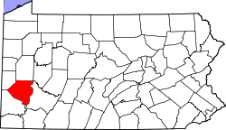
 Location in Allegheny County and the state of Pennsylvania | |
| Country | United States |
| State | Pennsylvania |
| County | Allegheny |
| Founded (as Bethel Township) | 1886 |
| Incorporated | 1949 (borough) |
| Government | |
| • Type | Council |
| • Mayor | Jack Allen |
| Area | |
| • Total | 11.7 sq mi (30.3 km2) |
| Elevation | 1,197 ft (365 m) |
| Population (2010) | |
| • Total | 32,313 |
| • Density | 2,869.8/sq mi (1,108.0/km2) |
| Time zone | Eastern (EST) (UTC-5) |
| • Summer (DST) | EDT (UTC-4) |
| ZIP code | 15102 |
| Area code(s) | 412 |
| Website | Bethel Park |
_2.jpg)
Bethel Park, referring to itself as the Municipality of Bethel Park,[1] is a borough with home rule status[2] in Allegheny County, Pennsylvania, United States, and is part of the Pittsburgh Metro Area, approximately 7 miles (13 km) southwest of Pittsburgh. The population was 32,313 at the 2010 census.
Geography
Bethel Park is located at 40°19′38″N 80°2′15″W / 40.32722°N 80.03750°W (40.327102, -80.037491).[3]
According to the United States Census Bureau, the borough had a total area of 11.7 square miles (30 km2), all of it land. Its average elevation is 1,197 feet (365 m) above sea level.[4] Bethel Park lies at the margin between the Pittsburgh Low Plateau and Waynesburg Hills Sections of the Allegheny Plateau physiographic province.[5] The area is characterized as a maturely dissected region where the ephemeral minor tributaries converge into the tributaries of principal streams.
The highest point in Bethel Park is Rocky Ridge, in the southwestern portion of the borough, 1,370 feet (420 m), and the lowest point is at the intersection of the Piney Fork and Alsip Run creeks, 980 feet (300 m), in the southeast corner.
Geology
The exposed rocks in Bethel Park are mostly composed of sandstone, limestone, shale, and a few coal layers (Redstone, Waynesburg, Washington, etc.). The ages of the exposed rocks bracket the late Pennsylvanian epoch (Gzhelian age; approximately 303 million years ago) near the lowest elevations, and early Permian period (Asselian age; approximately 297 million years ago) near the highest parts of the southern part of Bethel Park (e.g. Rocky Ridge). These sedimentary rocks were deposited as the sea level rose and fell along an ancient coastline (with the region alternating between delta, shallow lake, and shallow sea), and finally being uplifted with the formation of the Appalachian Mountains.
Bethel Park is underlain by the Pennsylvania-age Monongahela Formation. The Monongahela Formation consists of the Uniontown member and the underlying Pittsburgh member, and the base is the Pittsburgh coal seam. Much of southern Allegheny County is undermined, and the PADEP indicates that all of Bethel Park was undermined.[6]
A portion of the area is underlain by the Pittsburgh Terminal No. 8 Mine (Cortis and others, 1975), which was commonly known as the "H" Mine and the Coverdale Mine. The mine opened around 1920.[7] The historic operations of the Coverdale Mine are apparent on a Bridgeville 7.5-minute topographic map. A “Mine Dump” is shown adjacent to the Montour Railroad tracks and South Park Road. Coal was mined through vertical shafts accessing inclined slopes following the dip of the Pittsburgh coal seam. Mine voids in the inclined slope resulted from the practice of room and pillar mining during the early 20th century. The Coverdale Mine is closed and largely unflooded.[8]
Government
The borough's home rule status provides Bethel Park with greater powers of governance than the default form of borough government. It is divided into nine wards of approximately equal population, each electing one member of the Bethel Park Municipal Council, and all together electing the mayor at large. Both the mayor and the councilmen serve four-year terms. Each councilman is required to reside in the ward that he represents.[9]
Surrounding communities
- Baldwin Borough
- Castle Shannon
- Mt. Lebanon
- Peters Township (Washington County)
- South Park
- Upper St. Clair
- Whitehall
History

The area that is now Bethel Park was originally settled around 1800 and was first established as Bethel Township, in 1886. Bethel Park was incorporated as a borough on March 17, 1949,[10] and became a home rule municipality in 1978. The name was most likely named after a meeting house.[11]
The first armored car robbery in the U.S. occurred on March 11, 1927 when a Brinks truck, heading towards the Coverdale Mine about a mile away was attacked.[12][13] Paul Jaworski and his 'Flatheads" gang destroyed the road with dynamite to steal a mining payroll.[14]
Education
St. Thomas More School, part of the Roman Catholic Diocese of Pittsburgh, serving students Pre-School through 8th grade, is located in Bethel Park.
Demographics
| Historical population | |||
|---|---|---|---|
| Census | Pop. | %± | |
| 1950 | 11,324 | — | |
| 1960 | 23,650 | 108.8% | |
| 1970 | 34,758 | 47.0% | |
| 1980 | 34,755 | 0.0% | |
| 1990 | 33,823 | −2.7% | |
| 2000 | 33,556 | −0.8% | |
| 2010 | 32,313 | −3.7% | |
| Est. 2015 | 32,118 | [15] | −0.6% |
| Sources:[16][17][18][19] | |||
As of the census[18] of 2000, there were 33,556 people, 13,362 households, and 9,540 families residing in the borough. The population density was 2,869.8 people per square mile (1,108.3/km²). There were 13,871 housing units at an average density of 1,186.3 per square mile (458.1/km²). The racial makeup of the borough was 97.10% White, 1.02% African American, 0.03% Native American, 1.11% Asian, 0.03% Pacific Islander, 0.13% from other races, and 0.58% from two or more races. Hispanic or Latino of any race were 0.49% of the population.
There were 13,362 households, out of which 30.3% had children under the age of 18 living with them, 62.0% were married couples living together, 7.2% had a female householder with no husband present, and 28.6% were non-families. 26.1% of all households were made up of individuals, and 12.0% had someone living alone who was 65 years of age or older. The average household size was 2.48 and the average family size was 3.01.
In the borough the population was spread out, with 23.7% under the age of 18, 5.0% from 18 to 24, 26.8% from 25 to 44, 26.5% from 45 to 64, and 18.1% who were 65 years of age or older. The median age was 42 years. For every 100 females there were 91.9 males. For every 100 females age 18 and over, there were 87.7 males.
The median income for a household in the borough was $53,791, and the median income for a family was $64,390. Males had a median income of $47,876 versus $32,351 for females. The per capita income for the borough was $25,867. About 2.5% of families and 3.7% of the population were below the poverty line, including 4.1% of those under age 18 and 3.8% of those age 65 or over.
Points of interest in and around Bethel Park
- South Hills Village
- 11 community parks
- Bethel Park Community Center
- South Park
- South Park Wave Pool
- South Park Hundred Acres Manor
- Blade Runners
Bethel Park was also the location of Pittsburgh's first drive-in theater, South Park Drive-In (August 27, 1940-September 1, 1985). It was located on Route 88, just north of the entrance to South Park. South Park Commons, Jiffy Lube and Arby's now occupy the drive-in site.
Notable people
References
- ↑ "Local Government". Municipality of Bethel Park. Bethel Park. Retrieved 22 August 2015.
- ↑ Bogden, Sharon, ed. (2013). "The Pennsylvania Manual" (PDF). Commonwealth of Pennsylvania. pp. 6–5, 6–6. Retrieved 22 August 2015.
- ↑ "US Gazetteer files: 2010, 2000, and 1990". United States Census Bureau. 2011-02-12. Retrieved 2011-04-23.
- ↑ "US Board on Geographic Names". United States Geological Survey. 2007-10-25. Retrieved 2008-01-31.
- ↑ Sevon, 2000. http://www.dcnr.state.pa.us/topogeo/map13/map13.aspx
- ↑ Pennsylvania Department of Environmental Protection, Mine Subsidence Section (2005-11-15). "Municipality of Bethel Park, Allegheny County" (PDF).
- ↑ Washlaski, R.A., R.P. Washlaski and P.E. Starry, Jr. (2007). ""Coal Miners Memorial: "H" Mine, (Pittsburgh Terminal No. 8 Mine) (Coverdale Mine), Coverdale, Bethel Park, Allegheny County, PA"".
- ↑ Donovan, J.J., B R Leavitt and E Werner (2003). "Long-Term Changes in Water Chemistry as a Result of Mine Flooding in Closed Mines of the Pittsburgh Coal Basin, USA." (PDF). Proceedings of 6th International Conference for Acid Rock Drainage, Cairns, Qld., Australia, July 12–18, 2003. pp. 869–875.
- ↑ Bethel Park web page "Archived copy". Archived from the original on 2008-05-09. Retrieved 2008-05-06.
- ↑ "Allegheny County - 2nd Class" (PDF). Retrieved 2007-08-25.
- ↑ Ackerman, Jan (May 10, 1984). "Town names carry bit of history". Pittsburgh Post-Gazette. p. 6. Retrieved 31 October 2015.
- ↑ "Archived copy". Archived from the original on 2008-07-15. Retrieved 2009-01-10.
- ↑ "Bandits Dynamite Armored Pay Car and Take $104,250". The New York Times (March 12). March 12, 1927. Retrieved 2009-01-10.
- ↑ Sebak, Rick. "Gangster History in Bethel Park !". Archived from the original on 2008-07-15. Retrieved 2009-01-10.
- ↑ "Annual Estimates of the Resident Population for Incorporated Places: April 1, 2010 to July 1, 2015". Retrieved July 2, 2016.
- ↑ "Number of Inhabitants: Pennsylvania" (PDF). 18th Census of the United States. U.S. Census Bureau. Retrieved 22 November 2013.
- ↑ "Pennsylvania: Population and Housing Unit Counts" (PDF). U.S. Census Bureau. Retrieved 22 November 2013.
- 1 2 "American FactFinder". United States Census Bureau. Archived from the original on 2013-09-11. Retrieved 2008-01-31.
- ↑ "Annual Estimates of the Resident Population". U.S. Census Bureau. Retrieved 22 November 2013.
Further reading
- Dodge, C. H., 1985. Coal resources of Allegheny County, Pennsylvania—Part 1, Coal crop lines, mined-out areas, and structure contours. Pennsylvania Bureau of Topographic and Geologic Survey, Harrisburg, PA. Mineral Resources Report M 89, 68 p. (loose-leaf, 8½" x 11"), 64 maps, scale approx. 1:62,500.
- PADEP, 1999. The Effects of Subsidence Resulting from Underground Bituminous Coal Mining on Surface Structures and Features and Water Resources. Prepared under Authorization of Section 18a of the Bituminous Mine Subsidence and Land Conservation Act. March 1999.
External links
| Wikivoyage has a travel guide for Bethel Park. |
| Counties |  Map of the Pittsburgh Tri-State with green counties in the metropolitan area and yellow counties in the combined area. | |
|---|---|---|
| Major cities | ||
| Cities and towns 15k-50k (in 2010) | ||
| Airports | ||
| Topics | ||
| ||