York County, Pennsylvania
| York County, Pennsylvania | ||||||
|---|---|---|---|---|---|---|
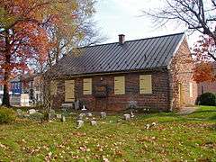
Clockwise from top left: A farm in York County, Golden Plough Tavern, York Friends Meeting House, and welcome sign. | ||||||
| ||||||
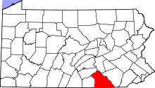 Location in the U.S. state of Pennsylvania | ||||||
 Pennsylvania's location in the U.S. | ||||||
| Founded | August 19, 1749 | |||||
| Seat | York | |||||
| Largest city | York | |||||
| Area | ||||||
| • Total | 911 sq mi (2,359 km2) | |||||
| • Land | 904 sq mi (2,341 km2) | |||||
| • Water | 6.5 sq mi (17 km2), 0.7% | |||||
| Population (est.) | ||||||
| • (2015) | 442,867 | |||||
| • Density | 490/sq mi (189/km²) | |||||
| Congressional district | 4th | |||||
| Time zone | Eastern: UTC-5/-4 | |||||
| Website |
yorkcountypa | |||||


York County is a county in the U.S. state of Pennsylvania. As of the 2010 census, the population was 434,972.[1] Its county seat is York.[2] The county was created on August 19, 1749, from part of Lancaster County and named either for the Duke of York, an early patron of the Penn family, or for the city and shire of York in England.
York County comprises the York-Hanover, PA Metropolitan Statistical Area, which is also included in the Harrisburg-York-Lebanon, PA Combined Statistical Area. It is in the Susquehanna Valley, a large fertile agricultural region in South Central Pennsylvania.
Based on the Articles of Confederation having been adopted in York by the Second Continental Congress on November 15, 1777, the local government and business community began referring to York in the 1960s as the first capital of the United States of America. The designation has been debated by historians ever since.[3] Congress considered York, and the borough of Wrightsville, on the eastern side of York County along the Susquehanna River, as a permanent capital of the United States before Washington, D.C., was selected.[4]
Geography
According to the U.S. Census Bureau, the county has a total area of 911 square miles (2,360 km2), of which 904 square miles (2,340 km2) is land and 6.5 square miles (17 km2) (0.7%) is water.[5] The county is bound to its eastern border by the Susquehanna River. Its southern border is the Mason–Dixon line, which separates Pennsylvania and Maryland.
Adjacent counties
- Cumberland County (north)
- Dauphin County (northeast)
- Lancaster County (east)
- Harford County, Maryland (southeast)
- Baltimore County, Maryland (south)
- Carroll County, Maryland (southwest)
- Adams County (west)
Major Highways
Demographics
| Historical population | |||
|---|---|---|---|
| Census | Pop. | %± | |
| 1790 | 37,535 | — | |
| 1800 | 25,643 | −31.7% | |
| 1810 | 31,958 | 24.6% | |
| 1820 | 38,759 | 21.3% | |
| 1830 | 42,859 | 10.6% | |
| 1840 | 47,010 | 9.7% | |
| 1850 | 57,450 | 22.2% | |
| 1860 | 68,200 | 18.7% | |
| 1870 | 76,134 | 11.6% | |
| 1880 | 87,841 | 15.4% | |
| 1890 | 99,489 | 13.3% | |
| 1900 | 116,413 | 17.0% | |
| 1910 | 136,405 | 17.2% | |
| 1920 | 144,521 | 5.9% | |
| 1930 | 167,135 | 15.6% | |
| 1940 | 178,022 | 6.5% | |
| 1950 | 202,737 | 13.9% | |
| 1960 | 238,336 | 17.6% | |
| 1970 | 272,603 | 14.4% | |
| 1980 | 312,963 | 14.8% | |
| 1990 | 339,574 | 8.5% | |
| 2000 | 381,751 | 12.4% | |
| 2010 | 434,972 | 13.9% | |
| Est. 2015 | 442,867 | [6] | 1.8% |
| U.S. Decennial Census[7] 1790-1960[8] 1900-1990[9] 1990-2000[10] 2010-2013[1] | |||

As of the census[11] of 2000, there were 381,751 people, 148,219 households, and 105,531 families residing in the county. The population density was 422 people per square mile (163/km²). There were 156,720 housing units at an average density of 173 per square mile (67/km²). The racial makeup of the county was 92.76% White, 3.69% African American, 0.18% Native American, 0.86% Asian, 0.03% Pacific Islander, 1.39% from other races, and 1.10% from two or more races. Hispanic or Latino of any race were 2.96% of the population. 42.0% were of German, 12.6% American, 7.7% Irish, 6.4% English and 5.1% Italian ancestry according to Census 2000. 94.8% spoke English and 2.9% Spanish as their first language.
There were 148,219 households out of which 32.50% had children under the age of 18 living with them, 58.30% were married couples living together, 9.00% had a female householder with no husband present, and 28.80% were non-families. 23.30% of all households were made up of individuals and 9.20% had someone living alone who was 65 years of age or older. The average household size was 2.52 and the average family size was 2.98.
In the county, the population was spread out with 24.60% under the age of 18, 7.50% from 18 to 24, 30.30% from 25 to 44, 24.00% from 45 to 64, and 13.50% who were 65 years of age or older. The median age was 38 years. For every 100 females there were 96.70 males. For every 100 females age 18 and over, there were 93.80 males.
As of 2006, the York-Hanover Metropolitan Statistical Area was the fastest-growing metro area in the Northeast region, and was ranked among the fastest-growing in the nation, according to the "2006 Population Estimates for Metropolitan and Micropolitan Statistical Areas" (U.S. Census Bureau). The estimates listed York-Hanover as the 95th fastest-growing metro area in the nation, increasing 9.1 percent between 2000 and 2006.
York County is home to Martin's Potato Chips in Thomasville, Utz Quality Foods, Inc. in Hanover, Snyder's of Hanover in Hanover, Hanover Foods in Hanover, Gibble's Potato Chips in York, Wolfgang Candy in York, The Bon-Ton in York, Dentsply in York, and a major manufacturing branch of Harley-Davidson Motor Company.
Dialect
The Central Pennsylvania accent and the Susquehanna dialect are the two most commonly heard speech patterns in the county, however there are numerous Mennonites and other persons of Pennsylvania Dutch descent that inhabit the county, who tend to speak with dialects similar to Pennsylvania Dutch English.
There is an increasingly large Hispanic population in and around the city of York, many of whom speak Spanish as their first language.
Metropolitan Statistical Area
The United States Office of Management and Budget has designated York County as the York-Hanover, PA Metropolitan Statistical Area.[12] The United States Census Bureau ranked the York-Hanover, PA Metropolitan Statistical Area as the 9th most populous in the state of Pennsylvania, and 115th most populous metropolitan statistical area in the United States as of July 1, 2012.[13]
The Office of Management and Budget has further designated the York-Hanover Metropolitan Statistical Area as a component of the more extensive Harrisburg-York-Lebanon, PA Combined Statistical Area,[12] the 43rd most populous combined statistical area and the 49th most populous primary statistical area of the United States as of July 1, 2012.[13][14] The CSA ranks 5th in the state of Pennsylvania.
Politics and government
As of November 2008, there are 299,414 registered voters in York County.[15]
- Republican: 143,261 (47.85%)
- Democratic: 112,207 (37.48%)
- Other Parties: 43,946 (14.68%)
County commissioners
- Susan Byrnes, Chairman, Republican
- Christopher B. Reilly, Vice-chairman, Republican
- Doug Hoke, Democrat
Other county offices
- Clerk of Courts, Don O'Shell, Republican
- Controller, Robb Green, Republican
- Coroner, Barry Bloss, Republican
- District Attorney, Thomas Kearney, Republican
- Prothonotary, Pamela S. Lee, Republican
- Recorder of Deeds, Randy Reisinger, Republican
- Register of Wills, Bradley C. Jacobs, Republican
- Sheriff, Richard P. Keuerleber III, Republican
- Treasurer, Barbara Bair, Republican
State House of Representatives
| District | Representative[16] | Party |
|---|---|---|
| 47 | Keith J. Gillespie | Republican |
| 92 | Mike Regan | Republican |
| 93 | Kristin Phillips Hill | Republican |
| 94 | Stanley E. Saylor | Republican |
| 95 | Kevin J. Schreiber | Democratic |
| 169 | Kate Klunk | Republican |
| 193 | Will Tallman | Republican |
| 196 | Seth Grove | Republican |
United States House of Representatives
| District | Representative | Party |
|---|---|---|
| 4 | Scott Perry | Republican |
Education

Public school districts
- Central York School District
- Dallastown Area School District
- Dover Area School District
- Eastern York School District
- Hanover Public School District
- Northeastern York School District
- Northern York County School District
- Red Lion Area School District
- South Eastern School District
- South Western School District
- Southern York County School District
- Spring Grove Area School District
- West Shore School District
- West York Area School District
- York City School District
- York Suburban School District
Vocational school
Public charter schools
- Helen Thackston Charter School (6–12) – York [17]
- Crispus Attucks Youthbuild Charter School (K–6) – York
- Lincoln Charter School (K–5) – York
- New Hope Academy Charter School (K–6) – York
- York Academy Regional Charter School
- York Adams Academy (formerly York County High School)
Independent schools
- York Country Day School (PreK–12)
- York Catholic High School (7–12)
- St. Joseph School (PreK–6)
Intermediate Unit
Lincoln Intermediate Unit (IU#12) region includes: Adams County, Franklin County and York County. The agency offers school districts, home schooled students and private schools many services including: special education services, combined purchasing, and instructional technology services. It runs Summer Academy which offers both art and academic strands designed to meet the individual needs of gifted, talented and high achieving students. Additional services include: Curriculum Mapping, Professional Development for school employees, Adult Education, Nonpublic School Services, Business Services, Migrant & ESL (English as a Second Language), Instructional Services, Management Services, and Technology Services. It also provides a GED program to adults who want to earn a high school diploma and literacy programs. The Lincoln Intermediate Unit is governed by a 13-member Board of Directors, each a member of a local school board from the 25 school districts. Board members are elected by school directors of all 25 school districts for three-year terms that begin the first day of July.[18] There are 29 intermediate units in Pennsylvania. They are funded by school districts, state and federal program specific funding and grants. IUs do not have the power to tax.
Colleges and universities
- Pennsylvania State University, Penn State York campus
- Harrisburg Area Community College – York Campus
- The Art Institute of York
- York College of Pennsylvania
- Consolidated School of Business in York
- York Technical Institute/York
- Yorktowne Business Institute
Adult education
- Baltimore School of Massage
- Consolidated School of Business in York
- DCS School of Driving, LLC
- Empire Beauty School
- Five Star Driver Training School, LLC
- George B Shue Driver Training School
- Krupinski Driving School
- Lurz Driver Education and Training Consultants Inc.
- Motorcycle Technology Center
- York Technical Institute/York
- York Time Institute
- Yorktowne Business Institute
Communities
Under Pennsylvania law, there are four types of incorporated municipalities: cities, boroughs, townships, and, in at most two cases, towns. The following cities, boroughs and townships are in York County:
City
- York (county seat)
Boroughs
- Cross Roads
- Dallastown
- Delta
- Dillsburg
- Dover
- East Prospect
- Fawn Grove
- Felton
- Franklintown
- Glen Rock
- Goldsboro
- Hallam
- Hanover
- Jacobus
- Jefferson
- Lewisberry
- Loganville
- Manchester
- Mount Wolf
- New Freedom
- New Salem
- North York
- Railroad
- Red Lion
- Seven Valleys
- Shrewsbury
- Spring Grove
- Stewartstown
- Wellsville
- West York
- Windsor
- Winterstown
- Wrightsville
- Yoe
- York Haven
- Yorkana
Townships
- Carroll
- Chanceford
- Codorus
- Conewago
- Dover
- East Hopewell
- East Manchester
- Fairview
- Fawn
- Franklin
- Heidelberg
- Hellam
- Hopewell
- Jackson
- Lower Chanceford
- Lower Windsor
- Manchester
- Manheim
- Monaghan
- Newberry
- North Codorus
- North Hopewell
- Paradise
- Peach Bottom
- Penn
- Shrewsbury
- Spring Garden
- Springettsbury
- Springfield
- Warrington
- Washington
- West Manchester
- West Manheim
- Windsor
- York
Census-designated places
Census-designated places are geographical areas designated by the U.S. Census Bureau for the purposes of compiling demographic data. They are not actual jurisdictions under Pennsylvania law. Other unincorporated communities, such as villages, may be listed here as well.
Unincorporated communities
- Accomac
- Admire
- Airville
- Ambau
- Bandanna
- Bermudian
- Big Mountain
- Blackrock
- Brogue
- Bryansville
- Cly
- Craley
- Davidsburg
- Detters Mill
- Fayfield
- Fireside Terrace
- Foustown
- Fuhrmans Mill
- Gatchellville
- Glades
- Glenville
- Gnatstown
- Hametown
- Hanover Junction
- Hopewell Center
- Kralltown
- Leaders Heights
- Mackey Ford
- Mount Royal
- New Bridgeville
- New Park
- Nauvoo
- Ore Valley
- Porters Sideling
- Siddonsburg
- Spring Forge
- Stoverstown
- Strinestown
- Sunnyburn
- Tolna
- Thomasville
- Valley Forge
- Violet Hill
- Woodbine
Population ranking
The population ranking of the following table is based on the 2010 census of York County.[19]
† county seat
| Rank | City/Town/etc. | Municipal type | Population (2010 Census)
|
|---|---|---|---|
| 1 | † York | City | 43,718 |
| 2 | Hanover | Borough | 15,289 |
| 3 | Weigelstown | CDP | 12,875 |
| 4 | Shiloh | CDP | 11,218 |
| 5 | East York | CDP | 8,777 |
| 6 | Parkville | CDP | 6,706 |
| 7 | Red Lion | Borough | 6,373 |
| 8 | Spry | CDP | 4,891 |
| 9 | West York | Borough | 4,617 |
| 10 | New Freedom | Borough | 4,464 |
| 11 | Dallastown | Borough | 4,049 |
| 12 | Shrewsbury | Borough | 3,823 |
| 13 | Grantley | CDP | 3,628 |
| 14 | Valley Green | CDP | 3,429 |
| 15 | Valley View | CDP | 2,817 |
| 16 | Manchester | Borough | 2,763 |
| 17 | Hallam | Borough | 2,673 |
| 18 | Emigsville | CDP | 2,672 |
| 19 | Dillsburg | Borough | 2,563 |
| 20 | Stonybrook | CDP | 2,384 |
| 21 | Wrightsville | Borough | 2,310 |
| 22 | Susquehanna Trails | CDP | 2,264 |
| 23 | Spring Grove | Borough | 2,167 |
| 24 | Stewartstown | Borough | 2,089 |
| 25 | Glen Rock | Borough | 2,025 |
| 26 | Dover | Borough | 2,007 |
| 27 | Pennville | CDP | 1,947 |
| 28 | North York | Borough | 1,914 |
| 29 | Yorklyn | CDP | 1,912 |
| 30 | Tyler Run | CDP | 1,901 |
| 31 | Jacobus | Borough | 1,841 |
| 32 | Queens Gate | CDP | 1,464 |
| 33 | Mount Wolf | Borough | 1,393 |
| 34 | Windsor | Borough | 1,319 |
| 35 | Loganville | Borough | 1,240 |
| 36 | Yoe | Borough | 1,018 |
| 37 | Goldsboro | Borough | 952 |
| 38 | East Prospect | Borough | 905 |
| 39 | New Market | CDP | 816 |
| 40 | Jefferson | Borough | 733 |
| 41 | Delta | Borough | 728 |
| 42 | York Haven | Borough | 709 |
| 43 | Winterstown | Borough | 632 |
| 44 | New Salem | CDP | 579 |
| 45 | Seven Valleys | Borough | 517 |
| 46 | Cross Roads | Borough | 512 |
| 47 | Felton | Borough | 506 |
| 48 | Franklintown | Borough | 489 |
| 49 | Fawn Grove | Borough | 452 |
| 50 | Lewisberry | Borough | 362 |
| 51 | Railroad | Borough | 278 |
| 52 | Wellsville | Borough | 242 |
| 53 | Yorkana | Borough | 229 |
Notable residents
- John Andrews, born in York County was a United States Navy sailor awarded the Medal of Honor for actions during the Korean Expedition in 1872
- Halestorm, rock band hailing from the town of Red Lion, located in Southern York County
- Bob Hoffman, founder of York Barbell, U.S. weightlifter named "Father of World Weightlifting" by the International Weightlifting Federation
- Brian Keene, best-selling novelist
- James Kelly, member of the United States House of Representatives from 1805–1809
- Jeff Koons, American artist and sculptor
- John Kuhn, NFL football player
- Live, popular rock band of the 1990s
- Craig Sheffer, actor
- James Alonzo Stahle, member of the U.S. House of Representatives from 1895–1897
- Tom Wolf, 47th governor of Pennsylvania
See also
- Cresap's War
- Lee's Diner
- National Register of Historic Places listings in York County, Pennsylvania
- Rabbit Transit
- Rehmeyer's Hollow – location of the 1928 Hex Hollow murder
References
- 1 2 "State & County QuickFacts". United States Census Bureau. Retrieved November 22, 2013.
- ↑ "Find a County". National Association of Counties. Retrieved July 2, 2016.
- ↑ McClure, Jim (December 9, 2007). "York: 'The first capital of the United States?'". York Town Square. York Daily Record/Sunday News. Retrieved 2009-05-17.
- ↑ "1776-1789". York Daily Record/Sunday News. September 14, 2006. Retrieved 2009-05-16.
- ↑ "2010 Census Gazetteer Files". United States Census Bureau. August 22, 2012. Retrieved March 11, 2015.
- ↑ "County Totals Dataset: Population, Population Change and Estimated Components of Population Change: April 1, 2010 to July 1, 2015". Retrieved July 2, 2016.
- ↑ "U.S. Decennial Census". United States Census Bureau. Retrieved March 11, 2015.
- ↑ "Historical Census Browser". University of Virginia Library. Retrieved March 11, 2015.
- ↑ Forstall, Richard L., ed. (March 24, 1995). "Population of Counties by Decennial Census: 1900 to 1990". United States Census Bureau. Retrieved March 11, 2015.
- ↑ "Census 2000 PHC-T-4. Ranking Tables for Counties: 1990 and 2000" (PDF). United States Census Bureau. April 2, 2001. Retrieved March 11, 2015.
- ↑ "American FactFinder". United States Census Bureau. Archived from the original on September 11, 2013. Retrieved 2011-05-14.
- 1 2 "OMB Bulletin No. 13-01: Revised Delineations of Metropolitan Statistical Areas, Micropolitan Statistical Areas, and Combined Statistical Areas, and Guidance on Uses of the Delineations of These Areas" (PDF). United States Office of Management and Budget. February 28, 2013. Retrieved March 20, 2013.
- 1 2 "Table 1. Annual Estimates of the Population of Metropolitan and Micropolitan Statistical Areas: April 1, 2010 to July 1, 2012" (CSV). 2012 Population Estimates. United States Census Bureau, Population Division. March 2013. Retrieved March 20, 2013.
- ↑ "Table 2. Annual Estimates of the Population of Combined Statistical Areas: April 1, 2010 to July 1, 2012" (CSV). 2012 Population Estimates. United States Census Bureau, Population Division. March 2013. Retrieved March 20, 2013.
- ↑ Running for Office Archived November 26, 2008, at the Wayback Machine.. Dos.state.pa.us. Retrieved on 2013-07-23.
- ↑ "Members of the House". Retrieved July 13, 2013.
- ↑ Pennsylvania Operating Charter Schools 2009-10, Pennsylvania Department of Education Report September 2009
- ↑ "Lincoln Intermediate Unit 12". iu12.org. Archived from the original on May 5, 2010. Retrieved April 24, 2010.
- ↑ "Archived copy". Archived from the original on December 21, 2013. Retrieved February 10, 2013.
Further reading
- Gibson, John, ed. A Biographical History of York County, Pennsylvania (Genealogical Publishing Com, 1886)
- Marcello, Ronald E. Small Town America in World War II: War Stories from Wrightsville, Pennsylvania (University of North Texas Press, 2014) 452 pp.
- Prowell, George Reeser. History of York County, Pennsylvania. Vol. 1. (JH Beers, 1907) online
External links
- York County official website
- Official Travel and Tourism site
- York County Heritage Trust
- York County history from the York Daily Record/Sunday News
- York County USGenWeb Project: good resource for History and Genealogy in York County
- York Town Square history blog
| Wikimedia Commons has media related to York County, Pennsylvania. |
Coordinates: 39°55′N 76°44′W / 39.92°N 76.73°W