Carbondale, Pennsylvania
| City of Carbondale | |
|---|---|
| City | |
|
| |
| Nickname(s): The Pioneer City | |
 City of Carbondale  City of Carbondale Location of Carbondale in Pennsylvania | |
| Coordinates: 41°34′N 75°30′W / 41.567°N 75.500°WCoordinates: 41°34′N 75°30′W / 41.567°N 75.500°W | |
| Country | United States |
| State | Pennsylvania |
| County | Lackawanna |
| Established | 1824 |
| Government | |
| • Mayor | Justin M. Taylor |
| Area | |
| • Total | 3.2 sq mi (8 km2) |
| • Land | 3.2 sq mi (8 km2) |
| • Water | 0.0 sq mi (0 km2) |
| Elevation | 1,076 ft (328 m) |
| Population (2010) | |
| • Total | 8,891 |
| • Density | 2,800/sq mi (1,100/km2) |
| Time zone | EST (UTC-5) |
| • Summer (DST) | EDT (UTC-4) |
| ZIP Code | 18407 |
| Area code(s) | 570 Exchanges: 281, 282 |
| Website |
carbondale-pa |
Carbondale is a city in Lackawanna County, Pennsylvania, United States.[1] Carbondale is located approximately 15 miles due northeast of the city of Scranton in Northeastern Pennsylvania. The population was 8,891 at the 2010 census.
The land area that became Carbondale was developed by William and Maurice Wurts, the founders of the Delaware and Hudson Canal Company, during the rise of the anthracite coal mining industry[1] in the early 19th century. Carbondale was the site of the first deep vein anthracite coal mine[2] in the United States. It was also a major terminal of the Delaware and Hudson Railroad.
Like many other cities and towns in the region, Carbondale has struggled with the demise of the once-prominent coal mining industry that had once made the region a haven for immigrants seeking work so many decades ago. Immigrants from Wales, England, Scotland, Ireland, and from throughout continental Europe came to Carbondale in the course of the nineteenth and early-twentieth centuries to work in the anthracite and railroading industries.
Geography
According to the United States Census Bureau, Carbondale has a total area of 3.2 square miles (8.3 km2), all of it land.
Schools
For the 2011-2012 school year, there are two schools located within the City of Carbondale.
- Carbondale Area Elementary (Grades K-6)
- Carbondale Area Jr./Sr. High (Grades 7-12)
The demographic and economic decline beginning in the 1950s with the end of the coal mining industry has left its mark on education. At one time, the City of Carbondale had one public high school, ten public elementary schools, one private Catholic high school, and two private Catholic elementary schools which served a city of just over 23,000 citizens. Over the decades, changes to education, the dramatic population decline down to 8,800 in the 2010 Census, and the disappearance of religious orders have reduced the number of schools to the two mentioned above. Sacred Heart Elementary, formed as a result of the merger between the parochial Mt. Carmel and St. Rose Elementary Schools for the 1998-1999 school year, closed at the end of the 2010-2011 school year and integrated into LaSalle Academy Catholic School in Dickson City. From a peak enrollment in the 1960s of nearly 650 in a K-12 system served in three schools, the school's enrollment has declined to 186.
Demographics
| Historical population | |||
|---|---|---|---|
| Census | Pop. | %± | |
| 1840 | 2,398 | — | |
| 1850 | 4,945 | 106.2% | |
| 1860 | 5,090 | 2.9% | |
| 1870 | 6,393 | 25.6% | |
| 1880 | 7,714 | 20.7% | |
| 1890 | 10,833 | 40.4% | |
| 1900 | 13,536 | 25.0% | |
| 1910 | 17,040 | 25.9% | |
| 1920 | 18,640 | 9.4% | |
| 1930 | 20,061 | 7.6% | |
| 1940 | 19,371 | −3.4% | |
| 1950 | 16,296 | −15.9% | |
| 1960 | 13,595 | −16.6% | |
| 1970 | 12,478 | −8.2% | |
| 1980 | 11,255 | −9.8% | |
| 1990 | 10,664 | −5.3% | |
| 2000 | 9,804 | −8.1% | |
| 2010 | 8,891 | −9.3% | |
| Est. 2015 | 8,566 | [3] | −3.7% |
| [4][5][6] | |||
As of the census[7] of 2010, there were 8,891 people, 3,734 households, and 2,234 families residing in the city. The population density was 2,778.4 people per square mile (1,072.7/km²). There were 4,144 housing units at an average density of 1,295 per square mile (505.9/km²). The racial makeup of the city was 96.2% White, 1% African American, 0.2% Native American, 0.4% Asian, 0.7% from other races, and 1.5% from two or more races. Hispanic or Latino of any race were 3.1% of the population.
There were 3,734 households, out of which 26.5% had children under the age of 18 living with them, 37% were married couples living together, 17.7% had a female householder with no husband present, and 40.2% were non-families. 35.1% of all households were made up of individuals, and 17% had someone living alone who was 65 years of age or older. The average household size was 2.32 and the average family size was 2.98.
In the city the population was spread out, with 23.1% under the age of 18, 57.3% from 18 to 64, and 19.6% who were 65 years of age or older. The median age was 41 years.
The median income for a household in the city was $27,574, and the median income for a family was $35,351. Males had a median income of $30,362 versus $21,922 for females. The per capita income for the city was $14,914. About 9.2% of families and 14.8% of the population were below the poverty line, including 23.6% of those under age 18 and 11.0% of those age 65 or over.
History
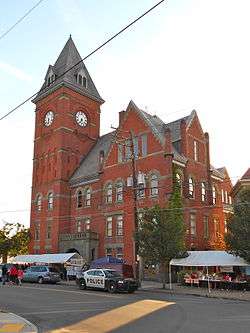
Today, the Carbondale Historical Society and Museum records and maintains that history. The Carbondale City Hall and Courthouse was added to the National Register of Historic Places in 1983.[8]
The Carbondale mine fire began in Carbondale in 1946.[9]
Notable "firsts"
- 1829: the Delaware and Hudson Gravity Railroad from Carbondale to Honesdale began operations on October 9, 1829. This was the first commercially successful railroad to operate in America.
- 1833: the first Saint Patrick's Day parade in what is now Lackawanna County is held in Carbondale, as stated in the Scranton Times-Tribune: “It comes as no surprise that the Irish people of Carbondale would want to celebrate the patron saint of their homeland. [. . .] The Feb. 28, 1833, issue of the Northern Pennsylvanian, the first newspaper published in Carbondale, contained a notice to “Hibernians” of a public meeting to be held [. . .] ‘for the purpose of taking measures to celebrate St. Patrick’s Day.’ [. . .] The Carbondale parade is the first one mentioned in any history of the region that is now Lackawanna County.”[10]
- 1850: the first eisteddfod (a Welsh musical and literary festival) in America was held in Carbondale on Christmas Day, 1850. Among the literarians and musicians who attended were Daniel Davies, Rev. John Moses, Thomas Eynon, Rev. Thomas J. Phillips, and Edward Jones. These were the pioneer eisteddofdwyr of America.
- 1851: Carbondale was incorporated as a city in Luzerne County on March 15, 1851,[11] making it the oldest city (the "Pioneer" city) in what later became Lackawanna County, and the fourth oldest city in the Commonwealth of Pennsylvania
- 1853: the first lodge in America of the ancient Welsh fraternal order of Ivorites was opened in Carbondale in the fall of 1853; the first public Ivorite celebration in America took place in Carbondale in August 1855, when a procession and other public exercises took place, under the direction of Thomas Voyle, Esquire, chief marshal, and Edward Roberts, Esquire.
Notable people
- Joseph Bambera, current Bishop of the Diocese of Scranton
- William J. Goebel, Democratic politician and 34th Governor of Kentucky serving for 3 days in 1900 before his death. He was the only sitting Governor to have been assassinated.
- Robert Wood Johnson I, an American entrepreneur and industrialist who founded the company Johnson & Johnson
- General Jerome F. O'Malley, U.S. Air Force 4-star general
- Terence V. Powderly, a well-known national figure as leader of the Knights of Labor from 1879 to 1893. Twice elected Mayor of Scranton, PA.
- Terry Pegula, Owner of the Buffalo Bills NFL team, Buffalo Sabres NHL team and Rochester Americans AHL team. Also a natural gas businessman.
- Andy Seigle, Professional basketball player for the Philippine Basketball Association, though born in Scranton, is a Carbondale native and the all-time leading scorer at Carbondale Area High School. He played for the University of New Orleans.
- Danny Seigle, Professional basketball player for the San Miguel Beermen of the Philippine Basketball Association. A standout at Wagner College, Danny led the Carbondale Area High School Chargers to 108-5 record in 4 years and a Pennsylvania Interscholastic Athletic Association Class AA Championship in 1993.
- James Archbald, born 1793, Little Cumbrae island, Ayrshire Coast, Scotland, first mayor of Carbondale
- Joseph R. Sarnoski, Congressional Medal of Honor recipient (World War II)
- Ed Wade, born 1956, Major League Baseball executive who served as Vice President and General Manager of the Philadelphia Phillies, 1998-2005 and the Houston Astros, 2008-2011. Credited with putting together the Phillies' core nucleus that led to the team's World Series Championship in 2008.[12]
- Tom Witts, born 1948, elected Mayor of Snellville, GA a suburb of Atlanta in 2015.after serving 6 years on the Snellville City Council.[13]
- Patrick De Lacey, born 1835, won a Medal of Honor during the American Civil War Battle of the Wilderness, by running ahead of the line under fire, shooting a Confederate color bearer, and capturing the flag.
- Stephen J. McConnell, born 1982, novelist, poet, essayist, journalist at The Scranton Times-Tribune newspaper from 2010-2013.[14]
- George D. Stoddard, born in 1897, president of the University of Illinois and the University of the State of New York. Chancellor of New York University and Long Island University.
Transportation
Highway
U.S. Business Route 6 runs down Main Street, Carbondale, as the main highway through the city. Recently completed after years of highly visible construction, the four-lane Robert P. Casey Memorial Highway U.S. Route 6 runs from Interstate 81 near Scranton north past Carbondale with interchanges outside, but close to, the city limits.
Rail
As the city responsible for the importation of America's first steam locomotive, the Stourbridge Lion in 1829, Carbondale was once a main terminus of the Delaware and Hudson Railway. It was also served by the Erie Railroad and the New York, Ontario and Western Railway.
Today Carbondale is served by the Pennsylvania Northeast Regional Rail Authority and its designated-operator Delaware-Lackawanna Railroad on a single remaining D&H mainline track running to Scranton.
The Delaware and Hudson Canal Gravity Railroad Shops have been demolished, but were once listed on the National Register of Historic Places.[8]
Bus
Carbondale is served by Greyhound and COLTS.
Local transportation
Carbondale is served by the #52 and #82 lines, run by COLTS bus.
In popular culture
- Carbondale holds an annual festival every summer called Pioneer Days, in honor of Carbondale's nickname, The Pioneer City. The festival features local bands, arts and crafts, carnival games, festival food, and a fireworks display.
- Carbondale was mentioned in "The Injury", an episode of NBC's television series The Office. "I got your pudding cups at a gas station in Carbondale", says the character Ryan Howard (played by actor B.J. Novak). It was also mentioned in the episode "Niagara", when Dwight Schrute, played by Rainn Wilson, mentions that Pam's best friend Isabel is "a dental hygienist from Carbondale and makes love like one." In the episode "Goodbye, Michael" Michael is initially unable to say goodbye to Pam because she is supposedly away pricing shredders in Carbondale.
- Carbondale was mentioned in "Chapter 9", an episode of Netflix's television series House of Cards (U.S. TV series). "We were supposed to leave for Carbondale 10 minutes ago."
- Annual Saint David’s Day Dinner, March 1: hosted by the Historical Society to commemorate the Welsh roots of the City of Carbondale and to celebrate the Welsh heritage of a great many residents of the Lackawanna and Wyoming Valleys in Pennsylvania.
- Annual Crystal Band Christmas Concert takes place on the first Sunday in December, hosted by the Historical Society and the Berean Baptist Church. The Crystal Band, founded in the Petersburg section of Scranton in 1887, is an all-volunteer concert band that is made up of residents from throughout northeastern Pennsylvania.
References
- 1 2
 Chisholm, Hugh, ed. (1911). "Carbondale". Encyclopædia Britannica (11th ed.). Cambridge University Press.
 - ↑ Tablet Marking The Site of The First Underground Coal Mine in Carbondale
- ↑ "Annual Estimates of the Resident Population for Incorporated Places: April 1, 2010 to July 1, 2015". Retrieved July 2, 2016.
- ↑ "1940 Census - Census of Population and Housing - U.S. Census Bureau". Census.gov. Retrieved 2012-09-03.
- ↑ "1960 Census of Population and Housing". Census.gov. Retrieved 2012-09-03.
- ↑ "1990 Census of Population and Housing Unit Counts United States" (PDF). Retrieved 2012-09-03.
- ↑ "American FactFinder". United States Census Bureau. Archived from the original on 2013-09-11. Retrieved 2011-05-14.
- 1 2 National Park Service (2010-07-09). "National Register Information System". National Register of Historic Places. National Park Service.
- ↑ Ann G. Kim; Thomas R. Justin; John F. Miller, Mine Fire Diagnostics Applied to the Carbondale, PA Mine Fire Site (PDF), retrieved June 1, 2014
- ↑ The Sunday Times, 6 March 2011, "Scranton's Green Party," Page P3, Scranton
- ↑ Hollister, Horace (1885). History of the Lackawanna Valley. Lippincott. p. 488.
- ↑ National news media
- ↑ Gwinnett Daily Post
- ↑ http://thetimes-tribune.com/news/wayne-county-inmate-accused-of-murder-only-remembers-the-first-10-of-92-stab-wounds-1.1332372
External links
| Wikisource has the text of the 1911 Encyclopædia Britannica article Carbondale. |
- The Carbondale Historical Society and D&H Transportation Museum
- https://www.facebook.com/pages/Carbondale-Historical-Society-Musem-Incorporated/152276618138160?ref=ts&fref=ts
Municipalities and communities of Lackawanna County, Pennsylvania, United States | ||
|---|---|---|
| Cities | 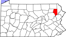 | |
| Boroughs | ||
| Townships | ||
| CDPs | ||
| Unincorporated communities |
| |