Brooke County, West Virginia
| Brooke County, West Virginia | |
|---|---|
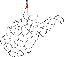 Location in the U.S. state of West Virginia | |
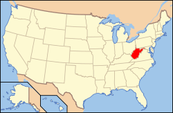 West Virginia's location in the U.S. | |
| Founded | November 30, 1797 |
| Named for | Robert Brooke |
| Seat | Wellsburg |
| Largest city | Follansbee |
| Area | |
| • Total | 93 sq mi (241 km2) |
| • Land | 89 sq mi (231 km2) |
| • Water | 3.4 sq mi (9 km2), 3.6% |
| Population (est.) | |
| • (2015) | 23,350 |
| • Density | 264/sq mi (102/km²) |
| Congressional district | 1st |
| Time zone | Eastern: UTC-5/-4 |
| Website |
www |
Brooke County is a county in the Northern Panhandle of the U.S. state of West Virginia. As of the 2010 census, the population was 24,069.[1] Its county seat is Wellsburg.[2] The county was created in 1797 from part of Ohio County[3] and named in honor of Robert Brooke, Governor of Virginia from 1794 to 1796.[4]
Brooke County is part of the Weirton-Steubenville, WV-OH Metropolitan Statistical Area, which is also included in the Pittsburgh-New Castle-Weirton, PA-WV-OH Combined Statistical Area.[5]
History
Brooke County was formed on November 30, 1796, from parts of Ohio County.
Geography
According to the U.S. Census Bureau, the county has a total area of 93 square miles (240 km2), of which 89 square miles (230 km2) is land and 3.4 square miles (8.8 km2) (3.6%) is water.[6] It is the second-smallest county in West Virginia by area. The highest point of elevation in Brooke County is approximately 1372 ft. and located about 1.5 miles south of Franklin.
Major highways
 U.S. Highway 22
 West Virginia Route 2
 West Virginia Route 27
 West Virginia Route 67
 West Virginia Route 88
Adjacent counties
- Hancock County (north)
- Washington County, Pennsylvania (east)
- Ohio County (south)
- Jefferson County, Ohio (west)
National protected area
Demographics
| Historical population | |||
|---|---|---|---|
| Census | Pop. | %± | |
| 1800 | 4,706 | — | |
| 1810 | 5,843 | 24.2% | |
| 1820 | 6,631 | 13.5% | |
| 1830 | 7,041 | 6.2% | |
| 1840 | 7,948 | 12.9% | |
| 1850 | 5,054 | −36.4% | |
| 1860 | 5,494 | 8.7% | |
| 1870 | 5,464 | −0.5% | |
| 1880 | 6,013 | 10.0% | |
| 1890 | 6,660 | 10.8% | |
| 1900 | 7,219 | 8.4% | |
| 1910 | 11,098 | 53.7% | |
| 1920 | 16,527 | 48.9% | |
| 1930 | 24,663 | 49.2% | |
| 1940 | 25,513 | 3.4% | |
| 1950 | 26,904 | 5.5% | |
| 1960 | 28,940 | 7.6% | |
| 1970 | 29,685 | 2.6% | |
| 1980 | 31,117 | 4.8% | |
| 1990 | 26,992 | −13.3% | |
| 2000 | 25,447 | −5.7% | |
| 2010 | 24,069 | −5.4% | |
| Est. 2015 | 23,350 | [7] | −3.0% |
| U.S. Decennial Census[8] 1790–1960[9] 1900–1990[10] 1990–2000[11] 2010–2015[1] | |||
2000 census
As of the census[12] of 2000, there were 25,447 people, 10,396 households, and 7,152 families residing in the county. The population density was 286 people per square mile (111/km²). There were 11,150 housing units at an average density of 126 per square mile (48/km²). The racial makeup of the county was 97.90% White, 0.85% Black or African American, 0.10% Native American, 0.34% Asian, 0.04% Pacific Islander, 0.09% from other races, and 0.69% from two or more races. 0.39% of the population were Hispanic or Latino of any race.
There were 10,396 households out of which 26.90% had children under the age of 18 living with them, 55.30% were married couples living together, 9.90% had a female householder with no husband present, and 31.20% were non-families. 27.90% of all households were made up of individuals and 14.40% had someone living alone who was 65 years of age or older. The average household size was 2.36 and the average family size was 2.88.
In the county, the population was spread out with 20.40% under the age of 18, 9.40% from 18 to 24, 25.80% from 25 to 44, 26.00% from 45 to 64, and 18.30% who were 65 years of age or older. The median age was 41 years. For every 100 females there were 91.80 males. For every 100 females age 18 and over, there were 89.90 males.
The median income for a household in the county was $32,981, and the median income for a family was $39,948. Males had a median income of $34,397 versus $19,711 for females. The per capita income for the county was $17,131. About 9.50% of families and 11.70% of the population were below the poverty line, including 16.40% of those under age 18 and 9.10% of those age 65 or over.
2010 census
As of the 2010 United States Census, there were 24,069 people, 10,020 households, and 6,636 families residing in the county.[13] The population density was 269.8 inhabitants per square mile (104.2/km2). There were 10,967 housing units at an average density of 122.9 per square mile (47.5/km2).[14] The racial makeup of the county was 97.0% white, 1.2% black or African American, 0.4% Asian, 0.1% American Indian, 0.2% from other races, and 1.1% from two or more races. Those of Hispanic or Latino origin made up 0.7% of the population.[13] In terms of ancestry, 21.5% were German, 17.5% were Irish, 16.4% were Italian, 11.5% were English, 7.2% were American, 5.9% were Scotch-Irish, and 5.7% were Polish.[15]
Of the 10,020 households, 25.8% had children under the age of 18 living with them, 50.7% were married couples living together, 10.7% had a female householder with no husband present, 33.8% were non-families, and 29.2% of all households were made up of individuals. The average household size was 2.32 and the average family size was 2.83. The median age was 44.8 years.[13]
The median income for a household in the county was $39,475 and the median income for a family was $52,528. Males had a median income of $39,065 versus $29,824 for females. The per capita income for the county was $22,377. About 7.9% of families and 11.0% of the population were below the poverty line, including 16.5% of those under age 18 and 7.8% of those age 65 or over.[16]
Law and Government
Brooke County is governed by a three-member County Commission who each serve in rotating 6-year terms. The terms are designed such that one seat is up for election in even years. The County Commission annually chooses its own President. The Brooke County Commissioners in 2008 are President Bernard Kazienko, Marty Bartz, and Norma Tarr.
Brooke County is part of the First Judicial Circuit of West Virginia, which also includes Hancock and Ohio counties. In West Virginia, Circuit Judges are elected in non-partisan elections to eight-year terms. The current judges of the First Judicial Circuit are the Hon. Jason A. Cuomo, the Hon. James Mazzone, the Hon. David J. Sims, and the Hon. Ronald E. Wilson. All four Circuit Court judges were re-elected in November 2016.
Brooke County is part of the First Family Court Circuit of West Virginia which also includes Hancock and Ohio Counties. In West Virginia, Family Court Judges were first elected to six-year terms beginning in 2002 and were elected to eight-year terms beginning in 2008. The current judges of the First Family Court Circuit are the Hon. Joyce Chernenko and the Hon. William Sinclair who were both elected to eight-year terms in November 2008.
Magistrates are elected in partisan elections serving four-year terms. Vacancies occurring in unexpired terms can be filled by a respective Circuit Court Judge. Unlike Circuit Court judges or Family Court judges, magistrates are not required to be attorneys. Brooke County currently has two magistrates: Michael H. Allman and Deborah Lunsford.
| Year | Republican | Democrat |
|---|---|---|
| 2016 | 68.32% 6,574 | 26.49% 2,549 |
| 2012 | 54.25% 5,060 | 42.94% 4,005 |
| 2008 | 50.33% 4,961 | 47.85% 4,717 |
| 2004 | 48.17% 5,189 | 50.99% 5,493 |
| 2000 | 44.60% 4,195 | 49.74% 4,678 |
Education
Brooke County is the home of Bethany College which is the oldest private college in the state.
The sole high school in the county is Brooke High School.
Communities
Cities
- Follansbee
- Weirton (part)
- Wellsburg (county seat)
Town
Villages
McKinleyville, West Virginia
Census-designated places
Unincorporated communities
- Arnold
- Coketown
- Colliers
- East Steubenville
- Fowlerston
- Franklin Community
- Rockdale
- Short Creek
McKinleyville, West Virginia
Miscellaneous topics
Brooke County has paid Emergency Medical Services. Brooke County EMS provides both advanced life support (ALS) and basic life support (BLS) to the majority of Brooke County 24/7/365 with Station 1 located in Wellsburg and Station 2 located in Follansbee.
See also
- Castleman Run Lake Wildlife Management Area
- Cross Creek Wildlife Management Area
- National Register of Historic Places listings in Brooke County, West Virginia
References
- 1 2 "State & County QuickFacts". United States Census Bureau. Retrieved January 9, 2014.
- ↑ "Find a County". National Association of Counties. Archived from the original on 2011-05-31. Retrieved 2011-06-07.
- ↑ "West Virginia: Individual County Chronologies". West Virginia Atlas of Historical County Boundaries. The Newberry Library. 2003. Retrieved August 10, 2015.
- ↑ "Archived copy". Archived from the original on 2012-10-22. Retrieved 2013-01-29.
- ↑ http://www.whitehouse.gov/sites/default/files/omb/bulletins/2013/b13-01.pdf
- ↑ "2010 Census Gazetteer Files". United States Census Bureau. August 22, 2012. Retrieved July 23, 2015.
- ↑ "County Totals Dataset: Population, Population Change and Estimated Components of Population Change: April 1, 2010 to July 1, 2015". Retrieved July 2, 2016.
- ↑ "U.S. Decennial Census". United States Census Bureau. Archived from the original on May 11, 2015. Retrieved January 9, 2014.
- ↑ "Historical Census Browser". University of Virginia Library. Retrieved January 9, 2014.
- ↑ "Population of Counties by Decennial Census: 1900 to 1990". United States Census Bureau. Retrieved January 9, 2014.
- ↑ "Census 2000 PHC-T-4. Ranking Tables for Counties: 1990 and 2000" (PDF). United States Census Bureau. Retrieved January 9, 2014.
- ↑ "American FactFinder". United States Census Bureau. Archived from the original on 2013-09-11. Retrieved 2011-05-14.
- 1 2 3 "DP-1 Profile of General Population and Housing Characteristics: 2010 Demographic Profile Data". United States Census Bureau. Retrieved 2016-04-03.
- ↑ "Population, Housing Units, Area, and Density: 2010 - County". United States Census Bureau. Retrieved 2016-04-03.
- ↑ "DP02 SELECTED SOCIAL CHARACTERISTICS IN THE UNITED STATES – 2006-2010 American Community Survey 5-Year Estimates". United States Census Bureau. Retrieved 2016-04-03.
- ↑ "DP03 SELECTED ECONOMIC CHARACTERISTICS – 2006-2010 American Community Survey 5-Year Estimates". United States Census Bureau. Retrieved 2016-04-03.
- ↑ "Dave Leip's Atlas of U.S. Presidential Elections". Retrieved 2016-11-18.
External links
- Official Brooke County Website
- Brooke County Schools
- Brooke County Public Library
- Brooke County Genealogy, Inc.
- WVGenWeb Brooke County
- Brooke County Economic Development Homepage
- Top of WV CVB, the Convention & Visitors Bureau for Brooke and Hancock Counties
 |
Hancock County | | ||
| Jefferson County, Ohio | |
Washington County, Pennsylvania | ||
| ||||
| | ||||
| Ohio County |
Municipalities and communities of Brooke County, West Virginia, United States | ||
|---|---|---|
| Cities | | |
| Town | ||
| Villages | ||
| CDP | ||
| Unincorporated communities | ||
| Footnotes | ‡This populated place also has portions in an adjacent county or counties | |
Coordinates: 40°16′N 80°35′W / 40.27°N 80.58°W