White Township, Indiana County, Pennsylvania
| White Township | |
|---|---|
| Township | |
|
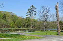
Pond along Pennsylvania Route 110 | |
| Etymology: Thomas White | |
 White Township Pennsylvania | |
| Coordinates: 40°36′0″N 79°8′0″W / 40.60000°N 79.13333°WCoordinates: 40°36′0″N 79°8′0″W / 40.60000°N 79.13333°W | |
| Country | United States |
| State | Pennsylvania |
| County | Indiana |
| Settled | 1772 |
| Area | |
| • Total | 42.9 sq mi (111 km2) |
| • Land | 42.6 sq mi (110 km2) |
| • Water | 0.3 sq mi (0.8 km2) |
| Elevation | 1,289 ft (393 m) |
| Population (2010) | |
| • Total | 15,821 |
| • Density | 370/sq mi (140/km2) |
| Time zone | EST (UTC-5) |
| • Summer (DST) | EDT (UTC-4) |
| ZIP code | 15701 |
| Area code(s) | 724 |
| School District | Indiana Area School District |
White Township is a township in Indiana County, Pennsylvania, United States. The population was 15,821 at the 2010 census.
Geography
White Township entirely surrounds, but does not include, the Borough of Indiana. However, the township does include the community of Chevy Chase Heights which is a census-designated place according to the US Census. The township also includes the communities of Ben Avon and Fulton Run.
According to the United States Census Bureau, the township has a total area of 42.9 square miles (111.0 km²), of which, 42.6 square miles (110.3 km²) of it is land and 0.3 square miles (0.8 km²) of it (0.70%) is water.
History
The first non-Indian settlers within the current-day boundaries of the township were Fergus Moorhead and his family, who arrived in 1772 and built a grist mill in 1774. In 1781, Moorhead and family constructed a small fort where Philadelphia Street intersects Heritage Run Road today.
White Township, named for Judge Thomas White, was officially formed as a municipality in 1843, from portions of Center, Washington, Green, and Armstrong Townships. On March 15, 1844, the first White Township municipal election was held, in which James Hood and William Ewing were elected supervisors, in addition to other township offices.
Demographics
As of the census[1] of 2000, there were 14,034 people, 6,025 households, and 3,741 families residing in the township. The population density was 329.6 people per square mile (127.3/km²). There were 6,553 housing units at an average density of 153.9/sq mi (59.4/km²). The racial makeup of the township was 94.17% White, 2.48% African American, 0.11% Native American, 2.14% Asian, 0.25% from other races, and 0.84% from two or more races. Hispanic or Latino of any race were 0.69% of the population.
There were 6,025 households, out of which 25.4% had children under the age of 18 living with them, 51.5% were married couples living together, 8.5% had a female householder with no husband present, and 37.9% were non-families. 32.6% of all households were made up of individuals, and 13.2% had someone living alone who was 65 years of age or older. The average household size was 2.23 and the average family size was 2.84.
In the township the population was spread out, with 20.0% under the age of 18, 9.7% from 18 to 24, 24.1% from 25 to 44, 26.4% from 45 to 64, and 19.8% who were 65 years of age or older. The median age was 43 years. For every 100 females there were 88.4 males. For every 100 females age 18 and over, there were 83.9 males.
The median income for a household in the township was $34,469, and the median income for a family was $49,235. Males had a median income of $40,165 versus $22,143 for females. The per capita income for the township was $21,432. About 8.1% of families and 12.1% of the population were below the poverty line, including 13.0% of those under age 18 and 7.6% of those age 65 or over.
References
- ↑ "American FactFinder". United States Census Bureau. Retrieved 2008-01-31.
External links
Municipalities and communities of Indiana County, Pennsylvania, United States | ||
|---|---|---|
| Boroughs | 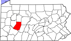 | |
| Townships | ||
| CDPs | ||
| Unincorporated communities | ||
| Counties |  Map of the Pittsburgh Tri-State with green counties in the metropolitan area and yellow counties in the combined area. | |
|---|---|---|
| Major cities | ||
| Cities and towns 15k-50k (in 2010) | ||
| Airports | ||
| Topics | ||
| ||