Curtisville, Pennsylvania
| Curtisville, Pennsylvania | |
|---|---|
| Census-designated place | |
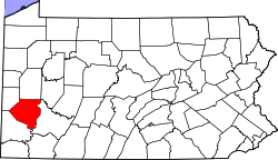
 Location in Allegheny County and state of Pennsylvania | |
| Coordinates: 40°38′36″N 79°50′43″W / 40.64333°N 79.84528°WCoordinates: 40°38′36″N 79°50′43″W / 40.64333°N 79.84528°W | |
| Country | United States |
| State | Pennsylvania |
| County | Allegheny |
| Township | West Deer |
| Area | |
| • Total | 1.4 sq mi (4 km2) |
| • Land | 1.4 sq mi (4 km2) |
| Population (2010) | |
| • Total | 1,064 |
| • Density | 760/sq mi (290/km2) |
| Time zone | Eastern (EST) (UTC-5) |
| • Summer (DST) | EDT (UTC-4) |
Curtisville is a census-designated place (CDP) in Allegheny County, Pennsylvania, United States. The population was 1,064 at the 2010 census.[1]
Geography
Curtisville is located at 40°38′36″N 79°50′43″W / 40.64333°N 79.84528°W (40.643248, -79.845371).[2]
According to the United States Census Bureau, the CDP has a total area of 1.4 square miles (3.6 km2), all of it land. Curtisville is within West Deer Township.
Demographics
As of the census[3] of 2000, there were 1,173 people, 498 households, and 330 families residing in the CDP. The population density was 822.5 people per square mile (316.7/km²). There were 528 housing units at an average density of 370.2/sq mi (142.6/km²). The racial makeup of the CDP was 98.81% White, 0.09% African American, 0.09% Asian, 0.26% from other races, and 0.77% from two or more races. Hispanic or Latino of any race were 1.11% of the population.
There were 498 households, out of which 29.1% had children under the age of 18 living with them, 48.6% were married couples living together, 11.8% had a female householder with no husband present, and 33.7% were non-families. 29.7% of all households were made up of individuals, and 13.9% had someone living alone who was 65 years of age or older. The average household size was 2.36 and the average family size was 2.89.
In the CDP the population was spread out, with 23.0% under the age of 18, 6.6% from 18 to 24, 32.7% from 25 to 44, 22.1% from 45 to 64, and 15.6% who were 65 years of age or older. The median age was 39 years. For every 100 females there were 93.2 males. For every 100 females age 18 and over, there were 88.5 males.
The median income for a household in the CDP was $31,304, and the median income for a family was $36,900. Males had a median income of $38,125 versus $23,710 for females. The per capita income for the CDP was $14,143. About 15.4% of families and 18.7% of the population were below the poverty line, including 24.3% of those under age 18 and 5.6% of those age 65 or over.
History
Curtisville was really three towns: Curtisville #1, Curtisville #2, and Curtisville #3 (now Bairdford), named after the mines that were in each area. For more information on Curtisville go to http://freepages.history.rootsweb.ancestry.com/~westdeertownship/West_Deer_1836-1986-final8.htm#_Toc82621316.
References
- ↑ "Race, Hispanic or Latino, Age, and Housing Occupancy: 2010 Census Redistricting Data (Public Law 94-171) Summary File (QT-PL), Curtisville CDP, Pennsylvania". U.S. Census Bureau, American FactFinder 2. Archived from the original on September 11, 2013. Retrieved September 30, 2011.
- ↑ "US Gazetteer files: 2010, 2000, and 1990". United States Census Bureau. 2011-02-12. Retrieved 2011-04-23.
- ↑ "American FactFinder". United States Census Bureau. Archived from the original on 2013-09-11. Retrieved 2008-01-31.
| Counties |  Map of the Pittsburgh Tri-State with green counties in the metropolitan area and yellow counties in the combined area. | |
|---|---|---|
| Major cities | ||
| Cities and towns 15k-50k (in 2010) | ||
| Airports | ||
| Topics | ||
| ||